Download
1 / 43
430 likes | 653 Views
UNIT 2 Georgia Geography and the Prehistoric Period. UNIT 2 ESSENTIAL QUESTION: How can I describe Georgia with regard to physical features and location?. UNIT 2 GEOGRAPHY of GEORGIA. LOCATION GEOGRAPHIC REGIONS PHYSICAL FEATURES.

E N D
UNIT 2 Georgia Geographyand thePrehistoric Period UNIT 2 ESSENTIAL QUESTION: • How can I describe Georgia with regard to physical features and location?
UNIT 2 GEOGRAPHY of GEORGIA • LOCATION • GEOGRAPHIC REGIONS • PHYSICAL FEATURES
SS8G1aLocate Georgia in relation to region, nation, continent, and hemispheres. Concept: LOCATION
The student will understand that location affects a society’s economy, culture, and development.Why are different places in the world very different from one another?How would you describe the location of Georgia to someone who lives in Saudi Arabia? Canada? California? LOCATION
LOCATION OF GEORGIA Essential Question #1: • Where in the world is Georgia?
Where in the World is Georgia? • Which hemispheres? • Which continent? • Which nation? • Which region?
SS8G1bDescribe the five geographic regions of Georgia; include the Blue Ridge Mountains, Valley and Ridge, Appalachian Plateau, Piedmont, and Coastal Plain. Concept: LOCATION
GEOGRAPHIC REGIONSOF GEORGIA Essential Question #2: • Where are the five regions of Georgia, and how are they similar and different?
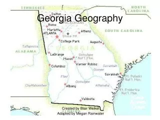
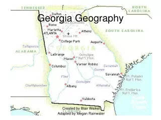
What are the five geographic regions of Georgia? - Appalachian Plateau - Valley and Ridge - Blue Ridge Mountains - Piedmont - Coastal Plains
APPALACHIAN PLATEAU Descriptions: • Georgia’s smallest region located in the northwest corner of the state • Part of the Appalachian Mountains
APPALACHIAN PLATEAU Descriptions: • Site of Lookout Mountain and Cloudland Canyon • Contains Georgia’s only coal deposits
VALLEY and RIDGE Description: • Located in northwest region of the state between Appalachian Plateau and Blue Ridge Mountains • Site of Chickamauga Valley and some Civil War battles
VALLEY and RIDGE Description: • Valleys are fertile for farming • Lots of hardwood and evergreen forests
BLUE RIDGE MOUNTAINS Description: • Located in northeast corner of Georgia • Also part of the Appalachian Mountains • Site of Brasstown Bald – GA’s largest peak at 4,784 feet
BLUE RIDGE MOUNTAINS Description: • Marble mineral resource makes Georgia famous • Corn & apples grown • A lot of precipitation due to high elevation – source of Savannah & Chattahoochee Rivers • 1st Gold rush in America
PIEDMONT Description: • 2nd largest region making up 1/3 of the land • Most populated region of Georgia • Rolling hills & farmland • Cotton production
PIEDMONT Description: • Site of Stone Mountain and Atlanta • Granite and kaolin mineral resources • Bordered to the south by the Fall Line
COASTAL PLAINS Description: • Once the bottom of the ocean floor – sandy soil in south, fertile soil in north • Flat landscape / navigable rivers • Saltwater wetlands along coast • Makes up 60% of the state
COASTAL PLAINS Description: • Site of Okefenokee Swamp & Barrier Islands • Bordered by the Fall Line to the north • Crops include peanuts, onions, & tobacco • Sparsely populated
Look at the map key. Which color represents the high elevation of mountains? Which part of the state is highest in elevation? What direction do many of the rivers flow?
SS8G1cLocate and evaluate the importance of key physical features on the development of Georgia; include the Fall Line, Okefenokee Swamp, Appalachian Mountains, Chattahoochee and Savannah Rivers, and barrier islands. Concept: LOCATION
PHYSICAL FEATURESOF GEORGIA Essential Question #3: • Where in the state of Georgia are you able to find the Fall Line, Okefenokee swamp, Appalachian Mountains, Chattahoochee and Savanna Rivers, and the barrier islands?
Appalachian Mtns What are some of the physical features of Georgia? Fall Line Savannah River Chattahoochee River Okefenokee Swamp Barrier Islands
What and here is the FALL LINE? • Natural boundary that separates the Piedmont and Coastal Plains regions
What and where is the FALL LINE? • Zone several miles wide marking prehistoric ocean shoreline • Augusta, Macon, & Columbus were built along Fall Line
What and where is the OKEFENOKEE SWAMP? • Georgia’s largest freshwater wetland
What and where is the OKEFENOKEE SWAMP? • Rich ecosystem with over 1,100 species of plants and animals • Okefenokee comes from the Seminoles meaning, "Land of Trembling Earth"
What and where are the APPALACHIAN MOUNTAINS? • Located in the northern three regions of Georgia (Appalachian Plateau, Ridge & Valley, and Blue Ridge Mountains) • Are the oldest mountains in North America
What and where are the APPALACHIAN MOUNTAINS? • Receives the most precipitation in the state due to higher elevations • Starting point of many of Georgia’s rivers • Site of famous Appalachian Trail
What and where is the CHATTAHOOCHEE RIVER? • Forms a boundary line between Georgia and Alabama • Starts in the Blue Ridge region and flows into the Gulf of Mexico
What and where is the CHATTAHOOCHEE RIVER? • Water is used for farming, business, and drinking supply
What and where is the SAVANNAH RIVER? • Forms a boundary between Georgia and South Carolina • Starts in the Appalachian Mtns and flows into the Atlantic Ocean
What and where is the SAVANNAH RIVER? • Generates hydroelectric power • Navigable for shipping
What and where are the BARRIER ISLANDS? • Site of Jekyll, Cumberland, Tybee, St. Simons, and many other islands • Freshwater rivers meet the salt water of the ocean at estuaries
What and where are the BARRIER ISLANDS? • Saltwater wetlands along coast are vital to the food chain • Provide protection from storms & waves • Site of Atlantic Intracoastal Waterway
THE END http://images.google.com/imgres?imgurl=http://georgiaregions.googlepages.com/map.jpg/map-full.jpg&imgrefurl=http://georgiaregions.googlepages.com/&usg=__r83H-LU8cyrVgiKoMHHi_u6cFWw=&h=600&w=400&sz=23&hl=en&start=30&um=1&tbnid=KXay7-a_vk7CaM:&tbnh=135&tbnw=90&prev=/images%3Fq%3Dpiedmont%2Bgeorgia%2Bmap%26ndsp%3D18%26hl%3Den%26sa%3DN%26start%3D18%26um%3D1