Download
1 / 28
280 likes | 343 Views
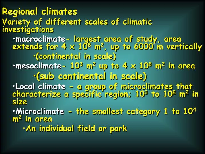
Regional climates Variety of different scales of climatic investigations macroclimate - largest area of study, area extends for 4 x 10 8 m 2 , up to 6000 m vertically (continental in scale) mesoclimate - 10 3 m 2 up to 4 x 10 8 m 2 in area (sub continental in scale)

E N D
Regional climates • Variety of different scales of climatic investigations • macroclimate- largest area of study, area extends for 4 x 10⁸ m2, up to 6000 m vertically • (continental in scale) • mesoclimate- 103 m2 up to 4 x 10⁸ m2 in area • (sub continental in scale) • Local climate - a group of microclimates that characterize a specific region; 103 to 108 m2 in size • Microclimate - the smallest category 1 to 104 m2 in area • An individual field or park
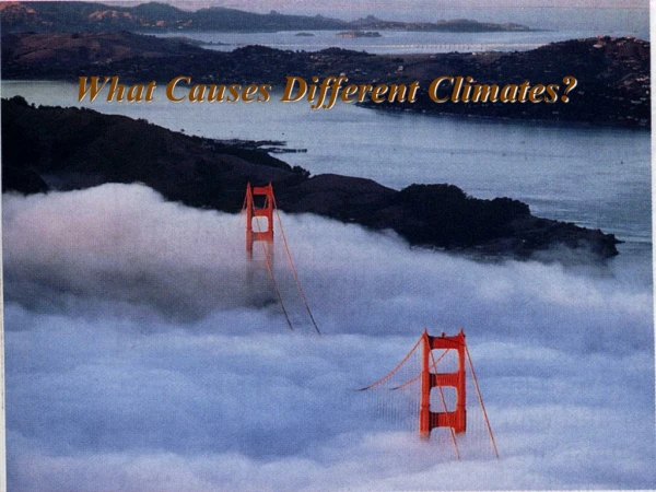
Climate classification: What, Why and How? What:Organize regions with similar climates Why:Understand what causes the climate to be what it is and when to worry about departures How:Look at moisture, temperature, evaporation, transpiration, vegetation, altitude, latitude, etc. and decide on some value that sets the boundary (threshold)- commonly related to plants
Köppen climate classification scheme • Uses Monthly mean temps, monthly mean precipitation, and annual mean temps to establish major climatic zones • designated with capital letters • Widely used but frequently criticized • no agreement between plants and climate • variability in the factors that set boundary • = climate classification changes constantly
Köppen Climate table Key characteristic for sub categorization Class Class name Subcategory Subcategory name No dry season A Tropical humid Af Tropical wet Short dry season; heavy monsoonal rains in other months Am Tropical monsoonal Winter dry season Aw Tropical savanna Low-latitude desert B Dry BWh Subtropical desert Low-latitude dry BSh Subtropical steppe Mid-latitude desert BWk Mid-latitude desert Mid-latitude dry BSk Mid-latitude steppe Mild with dry, hot summer C Mild Mid-Latitude Csa Mediterranean Mild with dry, warm summer Csb Mediterranean Mild with no dry season, hot summer Cfa Humid subtropical Mild with dry winter, hot summer Cwa Humid subtropical Mild with no dry season, warm summer Cfb Marine west coast Mild with no dry season, cool summer Cfc Marine west coast
Humid with severe Severe Mid-Latitude Humid continental winter, no dry season, hot summer D Dfa Humid with severe winter, no dry Humid continental season, warm summer Dfb Humid with severe, Humid continental dry winter, hot summer Dwa Humid with severe, Humid continental dry winter, warm summer Dwb Severe winter, no dry season, cool summer Dfc Subarctic Severe, very cold winter, no dry season, cool summer Dfd Subarctic Severe, dry winter, cool summer Dwc Subarctic Severe, very cold and dry winter, cool summer Dwd Subarctic Polar tundra, no true summer E Polar ET Tundra Perennial ice EF Ice Cap H Highland
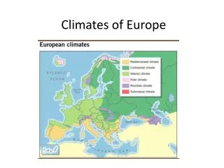
Climate zones of the world Divided into alphabetic categories A, B, C, D, E, H zones
KÖPPEN Climate classification Tropical climates designated with a capital “A” Based in part on vegetation zones that are sensitive to moisture and temperature
Tropical (A) Climates - All tropical climates are warm the subdivisions are based on differences in rain Tropical Rainforest (Af) Climates located 0-15° N/S Lat. Diurnal temperature range is greater than the difference between the warmest and coolest months (annual range). Every month has precipitation and no month is deficient in rainfall. This high amount of rainfall keeps the soil moisture at capacity. EVT occurs at potential rate
Am- Tropical monsoonal climate Diurnal temperature range is greater than the difference between the warmest and coolest months (annual range). seasonal precipitation surplus and deficit Distinctive dry and wet season related to wind reversal Aw- Tropical savanna climate Diurnal temperature range is greater than the difference between the warmest and coolest months (annual range). precipitation deficit much of the year Distinctive dry and wet season
B climates - semi-arid to arid Several sub categories
All B-climates have less than 30” of annual precipitation BW climates are arid (less than 10”) and can be divided further based on latitude (temperature) BWh- low latitude hot and dry BWk- mid latitude cool and dry BWh is a function of Hadley cell circulation; occur between 18 and 32° N-S Latitude
BS climates are semi-arid (more than 10” but less than 30” of rain) and can be divided further based on latitude (temps) BSh- low latitude hot and dry BSk- mid latitude cool and dry A gradational change from A climates on either side of the B climates
C climates- Mesothermal temperate Warm summers (<10°C); Mild Winters (between -3 to 18°C) Annual moisture distribution determines subcategories
C-subcategories Cf = moisture evenly distributed throughout the year Cw = 10x the amount of moisture in the summer as compared to the driest winter month Cs = 3x as much moisture in the winter as compared to the driest summer month; at least 1 month with less than 3 cm of precipitation
Csa= called Mediterranean climate • western edge of mid-latitude continents • Cfa= called a Humid subtropical climate • Southeastern edge of mid latitude continents • Cfb= called Marine west coast • Western edge of continents at higher latitudes
D climates- Severe Mid-latitude All have severe winters; short summers that range form hot in the south to cool to the north
E climates - Polar No true summer Cold all year long
Trewartha climate classification scheme- a modified version of the Köppen system. Attempts to redefine the broad climatic groups in such a way as to be closer to vegetational zoning. Group A- this is the tropical climate group, defined as places which do not receive annual winter frosts (in maritime regions this corresponds closely to the Köppen boundary). Climates with no more than 2 dry months are classified Ar , while others are classified Aw . There is no specific monsoon climate identifier. Group B- this is identical to the Köppen scheme. Group C- in the Trewartha scheme this category includes subtropical climates only (8 or more months above 10 °C). The identifiers are the same as the first two letters of the Köppen identifier - the Mediterranean climate is denoted Cs and the humid subtropical climate, Cf or Cw .
Trewartha Climate scheme (Continued) Group D- this group represents temperate climates. Continental climates are represented as Dca (Köppen Dfa, Dwa, Dsa ) and Dcb (Köppen Dfb ,Dwb ,Dsb ). Maritime temperate climates (Köppen Cfb ,Cwb ,Csb ,Cfc ) are denoted Do in the Trewartha classification. The dividing point between maritime and continental climates is 0 °C in the coldest month, rather than the usual Köppen value of -3 °C. Group E- this group is undivided and contains the continental subarctic climates (Köppen Dfc ,Dwc ,Dfd ) Group F- this is the polar climate group, split into Ft (Köppen ET ) and Fi (Köppen EF ). Group H- Highland climates - in which altitude is the most important factor determining climate.
Other climate classification schemes • Thornthwaite-based his scheme on moisture effectiveness and temperature efficiency • mathematical relationships easy to identify from available meteorological data • Also uses info on season when rain or snow falls
Genetic classification Identifies the “Why” of climates first and uses that information to establish each climatic zone -which air mass dominates
Air masses and climatic types Wet Dry Warm Cold
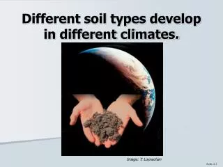
Vegetation • Closely linked to climate • Often used as PROXY data for lack of climate data • 5 distinct veggie zones • Forests = trees; many different types of forests • e.g., hardwood, conifer, rainforest • Deserts = discontinuous veggies; scrub brush; cactus, etc. • Grasslands = grasses • Taiga = cold; climate evergreen conifer forests • Tundra = cold; grasses sedges mosses and lichens