Download
1 / 5
50 likes | 172 Views
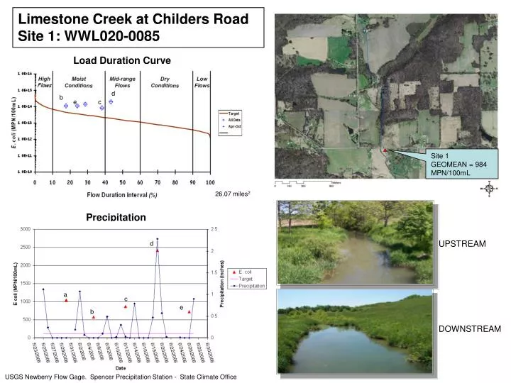
d. b. e. c. d. a. c. e. b. Limestone Creek at Childers Road Site 1: WWL020-0085. Load Duration Curve. a. Site 1 GEOMEAN = 984 MPN/100mL. 26.07 miles 2. Precipitation. UPSTREAM. DOWNSTREAM. USGS Newberry Flow Gage. Spencer Precipitation Station - State Climate Office. c. b.

E N D
d b e c d a c e b Limestone Creek at Childers Road Site 1: WWL020-0085 Load Duration Curve a Site 1 GEOMEAN = 984 MPN/100mL 26.07 miles2 Precipitation UPSTREAM DOWNSTREAM USGS Newberry Flow Gage. Spencer Precipitation Station - State Climate Office
c b e a d d e b c a Mill Creek at Country Club Rd. Site 9: WWL020-0077 Load Duration Curve Site 9 GEOMEAN = 425 MPN/100mL 19.11 miles2 19.11 miles2 Precipitation UPSTREAM DOWNSTREAM USGS Newberry Flow Gage. Spencer Precipitation Station - State Climate Office
e d c b a c d c a b Rattlesnake Creek at Hyden Rd. Site 18: WWL020-0081 Load Duration Curve Site 18 GEOMEAN = 323 MPN/100mL 25.15 miles2 25.15 miles2 Precipitation UPSTREAM DOWNSTREAM USGS Newberry Flow Gage. Spencer Precipitation Station - State Climate Office
e a b d c e a d b c Raccoon Creek at New Hope Rd. Site 26: WWL020-0067 Load Duration Curve Site 26 GEOMEAN = 389 MPN/100mL 26.45 miles2 26.45 miles2 Precipitation UPSTREAM DOWNSTREAM USGS Newberry Flow Gage. Spencer Precipitation Station - State Climate Office
Fish Creek at Splinter Ridge Rd. Site 31: WWL020-0091 Load Duration Curve b e d a c Site 31 GEOMEAN = 519 MPN/100mL 10.31 miles2 Precipitation UPSTREAM d b e c a DOWNSTREAM USGS Newberry Flow Gage. Spencer Precipitation Station - State Climate Office