Download
1 / 16
160 likes | 268 Views
NWS Briefing on Heavy Rainfall & Flooding Potential (Jan 8-9) January 5, 2008. weather.gov/portland. Satellite Imagery. Tues. Wed. Precipitable Water Imagery. Green: 2 plus inches of precipitable water Purple: 1.5 inches of precipitable water. Weather Graphics.

E N D
NWS Briefing on Heavy Rainfall & Flooding Potential (Jan 8-9) January 5, 2008 weather.gov/portland
Satellite Imagery Tues Wed
Precipitable Water Imagery Green: 2 plus inches of precipitable water Purple: 1.5 inches of precipitable water
Weather Graphics • Weather graphics at: - weather.gov/portland/emb.php
Snowpack Snow-WaterContent Coast Range250 – 500%of normal Cascades125 – 300%of normal weather.gov/portland
Snowpack Southwest Washington Pepper Creek SNOTEL Elevation: 2140’ Snow-Water: 15.5” Snow-Depth: 51.6” Sheep Canyon SNOTEL Elevation: 4030’ Snow-Water: 23.3” Snow-Depth: 82.8” Northwest Oregon Saddle Mountain SNOTEL Elevation: 3110’ Snow-Water: 20.2” Snow-Depth: 54.2” S Fork Bull Run SNOTEL Elevation: 2690’ Snow-Water: 14.0” Snow-Depth: 37.8” Seine Creek SNOTELOT Elevation: 2060’ Snow-Water 4.8” Snow-Depth 12.9” Jumpoff Joe SNOTELOT Elevation: 3520’ Snow-Water 10.5” Snow-Depth 34.6”
Quantitative Precipitation Forecast 4 am TUE – 4 am WED 4 am WED – 4 am THU 1 – 3 inches Coast Range & Cascades 4 – 6 inches Coast Range & Cascades
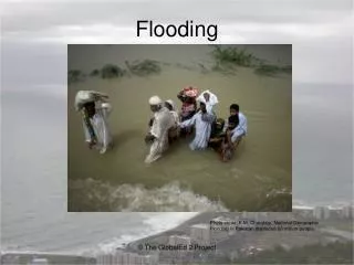
Coast Rivers Coast Rivers (Major Flooding Possible) Willapa, Naselle, and Grays in SW Washington Nehalem, Wilson, and Trask in NW Oregon weather.gov/portland
SW Washington Interior Highest Stages since 1996 possible on the lower Cowlitz River weather.gov/portland
Portland Metro &Willamette Valley Significant Flooding possible on all creeks and smaller rivers, including: Johnson CreekClackamas RiverSandy RiverTualatin RiverMolalla RiverPudding RiverSouth Yamhill RLuckiamute R weather.gov/portland
Mainstem Willamette Between Bankfull and Flood Stageat several locations weather.gov/portland
Summary • Coast/Coast Range/Willapa Hills: • Wind (Tues pm – Thurs am) • 35 mph gusts to 65 mph • Heavy rain (heaviest Tillamook County northward) • Tues night through Thursday midday • Tues night: 0.5 – 1.5 inches • Wed/Thurs: 4 - 8 inches • Freezing Levels: 8,000 – 9,000 feet • Temperature: (Tues-Thurs) • Lows: low to mid 40s • Highs: upper 40s to low 50s
Summary • Valleys/Gorge/Lwr Columbia/Cowlitz County: • Heavy rain (heaviest Marion county northward) • Tues night through Thursday midday • Tues night: 0.25 – 1.0 inches • Wed/Thurs: 2 - 5 inches • Heaviest precipitation southwest WA • Freezing Levels: 8,000 – 9,000 feet • Temperature: (Tues-Thurs) • Lows: low to mid 40s • Highs: upper 40s to near 50
Summary • Foothills/Cascades: • Heavy rain (heaviest Linn county northward) • Tues night through Thursday midday • Tues night: 0.25 – 1.0 inches • Wed/Thurs: 3 - 7 inches • Heaviest rainfall in southwest WA foothills • Freezing Levels: 8,000 – 9,000 feet • Temperature: (Tues-Thurs) • Lows: mid 30s to near 40 • Highs: 40s
Questions? Graphics available at: http://weather.gov/portland/emb.php Presentations slideshow will be emailed to you shortly. weather.gov/portland