Download
1 / 41
410 likes | 518 Views
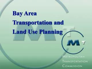
RPS Land Use and Transportation Modeling Results. Presentation to RPS TAC & MPO TAC Brian Gregor Transportation Planning Analysis Unit May 17, 2006. Presentation Outline Modeling background Description of land use model (LUSDR) Land use results Transportation results. Modeling Background.

E N D
RPS Land Use and Transportation Modeling Results Presentation to RPS TAC & MPO TAC Brian Gregor Transportation Planning Analysis Unit May 17, 2006
Presentation Outline • Modeling background • Description of land use model (LUSDR) • Land use results • Transportation results
Urban reserves are future sources of land for inclusion into urban growth boundaries. They affect future transportation demand. Land Use and Transportation Planning Highway location affects land development patterns. Urban development goes in urban growth boundaries. Legend County Urban Growth Area County lands are predominantly resource zoning and very low density development. Poss. Urban Reserve Highway Poss. Highway
Approaches to Land Use and Transportation Modeling • Most common practice is to make aspirational-concensus land use forecasts. These are fixed for all transportation modeling. • With integrated land use and transport models, land use allocations vary with transportation, but almost all just produce one land use pattern. • The LUSDR model is also sensitive to transportation policies but recognizes that land many develop in many ways.
Why Evaluate Alternative Land Use Patterns? • The overall number of trips may not change much, but the patterns of trip origins and destinations will. • Roadway traffic can be very different depending on the land use assumptions. • Assessment of many plausible land use patterns help identify potential problems. D O O D O O D D
A 25 15 Number of Scenarios 5 0 0 2000 4000 6000 8000 Traffic Volume B 35 25 Number of Scenarios 15 5 0 0 2000 4000 6000 8000 Traffic Volume Modeling Multiple Scenarios to Assess Risks A B
Jackson County Regional Problem Solving (RPS) Study • Goal of RPS: To achieve regional consensus on where urban reserves should be designated to accommodate a doubling of population. • Modeling Objectives • Develop a moderately large set of plausible future land use patterns. • Model the effects of the different land use patterns on the transportation system. • Identify key features of land use patterns affecting transportation performance.
Land Use Scenario DevelopeR • Creates variation through stochastic microsimulation. • Stochastic means that there is a random component to the model but average behavior is replicated. • Microsimulation means that individual household, business and development decisions are modeled.
Might be located here in another simulation Shopping center might be located here in one simulation Stochastic Microsimulation = all of these places meet requirements
Generate Households HhSize Worker AgeOfHead Income Ownrent Bldgtype Hh1 h2 w2 a1 i4 rent SFD Hh2 h2 w1 a4 i2 rent SFD Hh3 h2 w3 a1 i2 rent A5P Hh4 h3 w2 a2 i3 own SFD Hh5 h1 w2 a2 i1 own SFD Hh6 h4 w4 a2 i5 own SFD Hh7 h2 w3 a1 i3 rent SFD Hh8 h2 w1 a2 i5 own SFD Hh9 h2 w3 a3 i1 rent SFD Hh10 h2 w1 a3 i5 own SFD Hh11 h2 w1 a3 i4 rent SFA Hh12 h3 w2 a4 i4 rent A24 Hh13 h4 w3 a2 i4 rent MH Hh14 h2 w2 a2 i2 own SFD
Comparisons of Observed and Simulated Household Building Types
Assign to Developments HhSize Worker AgeOfHead Income Ownrent Bldgtype DevId Hh1 h1 w1 a1 i5 own SFDH SFDH-161 Hh2 h1 w1 a1 i3 own MHpark MHpark-1 Hh3 h1 w1 a1 i4 rent SFDM SFDM-126 Hh4 h1 w1 a1 i1 rent SFDM SFDM-207 Hh5 h1 w1 a1 i2 rent SFDM SFDM-758 Hh6 h1 w1 a1 i2 rent SFDM SFDM-660
Generate Employment Establishments and Put in Developments Id DevType LocType NumEmp UnitArea TotArea UnitPrice Period ACC-3 ACC EmpGrp6 3 6256.882 22524.775 9.133772 p4 ACC-1 ACC EmpGrp6 98 6256.882 735809.323 9.133772 p1 ACC-12 ACC EmpGrp6 1 6256.882 7508.258 9.133772 p2 ACC-14 ACC EmpGrp6 2 6256.882 15016.517 9.133772 p4 ACC-8 ACC EmpGrp6 2 6256.882 15016.517 9.133772 p3 ACC-4 ACC EmpGrp6 6 6256.882 45049.550 9.133772 p1
Locate Developments • For each development • Identify set of candiate TAZs • Choose TAZ based on preference probabilities (considering slope, distance to interchange, traffic exposure, accessibility) • For each TAZ • Balance supply and demand based on plan compatibility and willingness to pay • Repeat as necessary until all developments are sited
Preference Probability Example 1: Construction & Manufacturing
Preference Probability Example 1: Retail and similar Retail Preference Probabilities
5 How to Interpret the Shapes ofBox Percentile Plots 39000 center line shows the median value fifty percent of the values are between the top and bottom horizontal lines 38000 Employment top and bottom show the range of values 37000 the width indicates the relative frequency of the value 36000
VMT by Functional Class and Scenario 1 2 3 4 5 30 1 1638000 964000 1027000 1025000 239000 62000 2 1646000 978000 1024000 998000 243000 62000 3 1612000 972000 1042000 1002000 252000 61000 4 1646000 961000 1025000 1035000 233000 63000 5 1668000 952000 1022000 1004000 244000 64000 6 1639000 955000 1032000 1016000 252000 61000 7 1648000 958000 1034000 1023000 252000 63000 8 1634000 948000 1054000 1031000 257000 61000 9 1631000 950000 1021000 1011000 246000 62000 10 1628000 974000 1045000 1020000 255000 61000 11 1639000 969000 1024000 1027000 239000 61000 12 1650000 938000 1053000 1021000 243000 62000 13 1620000 968000 1034000 996000 250000 62000 14 1635000 965000 1034000 1019000 234000 61000 15 1633000 969000 1033000 1021000 248000 63000
ADT by Location and Scenario 1 2 3 4 5 6 7 8 1 43800 8000 12300 55400 36300 47900 12300 23100 2 40800 7200 13500 56000 34400 47800 11100 23700 3 43600 7800 13100 54800 36600 46800 11100 23600 4 41300 7800 13400 56500 36600 48300 11700 23200 5 43300 7900 13100 57000 35200 49100 11600 22900 6 44000 7700 10200 53700 38100 47600 10800 23400 7 43500 8600 15600 58600 39400 46500 11100 23900 8 44000 7700 11100 54600 42100 48000 10400 24100 9 44500 8300 11700 55100 34900 48500 11000 23100 10 43600 8200 12300 54500 40800 48600 11300 23400 11 41400 7600 11800 54000 42300 47900 10500 23500 12 44400 7200 10200 54300 41500 49700 11200 22900 13 46800 7500 17200 58600 35700 47300 11400 23900 14 43300 7800 12200 55100 37700 49700 12000 23300 15 45000 8500 13100 55900 36400 47800 11300 23600
ADT by Location and Scenario 1 2 3 4 5 6 7 8 9 10 1 12.5 5.1 3.2 6.9 11.9 13.3 8.1 13.9 8.0 5.0 2 11.6 4.6 3.6 7.0 11.3 13.3 7.3 14.2 7.9 5.4 3 12.4 5.0 3.5 6.9 12.0 13.0 7.3 14.2 8.0 5.1 4 11.8 5.0 3.5 7.1 12.0 13.4 7.7 13.9 8.0 5.6 5 12.3 5.1 3.4 7.1 11.5 13.6 7.6 13.8 8.1 5.0 6 12.5 4.9 2.7 6.7 12.5 13.2 7.1 14.0 7.8 5.1 7 12.4 5.5 4.1 7.3 12.9 12.9 7.3 14.3 8.1 5.6 8 12.5 4.9 2.9 6.8 13.8 13.3 6.8 14.5 7.8 5.1 9 12.7 5.3 3.1 6.9 11.4 13.5 7.2 13.9 7.9 5.3 10 12.4 5.2 3.2 6.8 13.4 13.5 7.4 14.0 8.0 5.6 11 11.8 4.9 3.1 6.8 13.8 13.3 6.9 14.1 7.9 6.0 12 12.6 4.6 2.7 6.8 13.6 13.8 7.4 13.8 8.0 5.1 13 13.3 4.8 4.5 7.3 11.7 13.1 7.5 14.3 7.9 5.1 14 12.3 5.0 3.2 6.9 12.4 13.8 7.8 14.0 7.9 5.3 15 12.8 5.4 3.4 7.0 11.9 13.3 7.4 14.1 7.9 5.6
Next Steps • Complete analysis of transportation performance measures. • Show measures of transportation results as well as variation in measures. • Identify transportation problems. • Analyze relationship between transportation problems and land use patterns. • Write up results. • Develop presentation of results.