Download
1 / 57
580 likes | 695 Views
Ch 3 Ocean Circulation. Surface Circulation. Driven by the wind Strongest currents are on the surface Driven by heat energy from the sun. The Coriolis Effect.

E N D
Surface Circulation • Driven by the wind • Strongest currents are on the surface • Driven by heat energy from the sun
The Coriolis Effect • The tendency of objects moving large distances on the earth’s surface to bend to the right in the Northern Hemisphere and to the left in the Southern Hemisphere • Due to the Earth being round and rotating • Anything that moves over its surface tends to turn a little rather than moving in a straight line • Influences surface currents and wind
Coriolis Effect • Video • http://www.youtube.com/watch?v=aeY9tY9vKgs • 6:10
Wind patterns • Wind is driven by heat energy from the sun • More energy is absorbed around equator • Air at equator is less dense and rises • Air from adjacent areas gets sucked in to replace rising equatorial air • This creates wind that is bent by the Coriolis effect: “trade winds” . Steadiest winds on Earth
Surface currents • Winds push sea surface creating currents • Currents move at a 45 degree angle from the wind due to Coriolis effect • Top layer of water pushes the layer below which will move slightly to the right and slightly slower • Called Ekman Spiral
Ekman layer- upper part of the water column that is affected by the wind • Ekman layer moves at 90 degrees from the wind direction- Ekman transport • Page 50 “ the coriolis effect causes surface currents to move at 45 degrees from the wind that drives them. Lower water layers move at progressively greater angles from the wind in a pattern called an Ekman spiral. This produces Ekman transport, in which the upper part of the water column moves perpendicular to the wind direction, to the right in the Northern Hemisphere and the left in the Southern Hemisphere”
Ekman Transport • If the ocean current is regarded as layered, then each deeper layer moves more slowly than the overlying layer
Caption under figure 3.18 page 51 • The major wind patterns on earth are created by the rising of sun warmed air and the sinking of cold air. The trade winds lie between about 30 degrees north and south latitude and are the steadiest of all winds. The westerlies are found from about 30 to 60 degrees, and above 60 degrees lie the most variable winds, the polar westerlies. The transition zones or boundaries between these major wind belts have very light and changeable winds.
Equatorial currents- major ocean currents that move parallel to the equator • Gyres- A large, nearly circular system of wind driven surface currents that center around latitude 30 degrees in both hemispheres • Gyres moderate climate by bringing warm water north and cold water south
What are gyres? 2:22 • http://www.youtube.com/watch?v=h6i16CrI8ss
High heat capacity and gyres • The warm currents on the western side of the gyres carry vast amounts of solar heat from the Equator to higher latitudes • Cold currents flow in the opposite direction on the eastern sides • Ocean currents act as a thermostat, warming the poles, cooling the tropics, and regulating the climate of our planet
The “EAC” • The East Australian Current (EAC) is a complex and highly energetic western boundary system in the south-western Pacific off eastern Australia. The EAC forms part of the western boundary of the South Pacific Gyre and the linking element between the Pacific and Indian Ocean gyres • The EAC has an important role in removing heat from the tropics and releasing it to the mid-latitude atmosphere
“It’s the EAC, dude”….. • It can reach speeds of up to 7 knots in some of the shallower waters along the Australian continental shelf, but is generally measured at 2 or 3 knots.
Clip from “Finding Nemo” • http://www.youtube.com/watch?v=JpV7NIJTxD0 • http://www.youtube.com/watch?v=Yupi9qYB7yM
http://www.tasfish.com/index.php?option=com_content&view=article&id=431:the-east-australian-current-&catid=72:issue-48-feb-2004&Itemid=122http://www.tasfish.com/index.php?option=com_content&view=article&id=431:the-east-australian-current-&catid=72:issue-48-feb-2004&Itemid=122
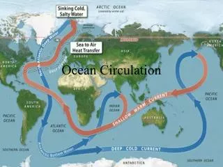
Thermohaline Circulation and the Great Ocean Conveyor • Densest water sinks • Therefore, the ocean is usually layered or STRATIFIED with the densest water on the bottom and the least dense on the surface • Deep water is cold and dense • Surface water is relatively warm and light
3 layers of the ocean • Surface layer- usually 100-200 m deep • Mixed by wind, waves, and currents • “mixed layer” • Thermoclines-a zone in the water column that shows a sudden change in temperature with depth. The main thermocline is the zone where the temp change marks the transition between the warm surface water and the cold deep water
Intermediate layer • Below the surface layer • 1,000-1,500 m • The main thermocline is the zone where the temp change marks the transition between the warm surface water and the cold deep water • The main thermocline breaks down only occasionally. There are permanent and seasonal thermoclines
Deep and bottom layers • Uniformly cold • less than 4 degrees C (39 degrees F)
Review video 9:42 • http://www.youtube.com/watch?v=IbY1_YYWLEA • http://www.youtube.com/watch?v=1PWjOMrPkrI
Stability and Overturn • Stable water column- warmer water floats on top of denser water below unless wind or wave energy stirs it • Stability depends on density difference • Unstable water column- surface water sinks causing downwelling and displaces and mixes with deeper water
Downwelling • If intense, a large volume may leave the surface without mixing much • Changes salinity • Because circulation is driven by changes in density, which in turn is determined by temperature and salinity, downwelling circulation is known as THERMOHALINE circulation
Downwelling • http://www.youtube.com/watch?v=SHTDzLlUU6M
The great ocean conveyor • Global, thermohaline circulation • Transports heat and salt • Mixes the oceans on a timescale of about 4,000years • Constantly replenishes the oxygen supply in the depths • http://oceanservice.noaa.gov/facts/conveyor.html
NASA: The Great Ocean Conveyor Video • http://www.youtube.com/watch?v=3niR_-Kv4SM • http://www.youtube.com/watch?v=SdgUyLTUYkg
NOAA tides and water • http://oceanservice.noaa.gov/education/tutorial_tides/lessons/tides_tutorial.pdf • Site for question sheet
Waves page 55-56 • Define: • Crest • Trough • Height • Wavelength • Period • Fetch • Seas • Swells • surf
Fetch • Fetch- the span of open water over which the wind blows • It is important in determining the size of waves • Wind starts the wave which eventually settles out into a swell as it gets farther from the source of wind
When waves reach shallow water, they get higher and shorter (closer together). They become unstable and break- expending their energy on the shoreline • In shallower water the influence of the bottom causes the particle motion to flatten out into a back and forth movement known as surge
Water particles do not move along with a wave but instead move in circles. When under the crest they move up and forward with the wave then they are pulled back down. • As wave after wave passes, the water and anything floating in or on it moves in circles
Digital Wave Maker- Nat’l geographic • http://education.nationalgeographic.com/education/multimedia/interactive/wave-simulator/?ar_a=1
Tallest wave ever recorded • http://geology.com/records/biggest-tsunami.shtml
Waves • http://www.youtube.com/watch?v=0X7d9hMVJWQ&feature=related • http://www.youtube.com/watch?v=7nS_aR8XX_U
Tides page 57 • The moon does not rotate around the earth. Both the moon and earth rotate around their common center of mass • What causes tides? • The gravitational pull of the moon and sun an by the rotation of earth, moon, and sun • Read page 57 “why are there tides” • EXPECT THIS TO BE AN ESSAY QUESTION
Centrifugal force produced by the earth’s motion causes water to bulge outward, away from the moon • On the side of the earth closest to the moon, the gravitational pull overcomes the centrifugal force and pulls the water into a bulge toward the moon
http://www.youtube.com/watch?v=l37ofe9haMU • http://www.youtube.com/watch?v=aN2RM5wa1ek
How does a grunion (Leuresthestenuis) use the tide? http://video.nationalgeographic.com/video/news/animals-news/us-grunion-spawning-vin/
“Grunion Run” calendar • http://www.dfg.ca.gov/marine/grunionschedule.asp
High tidepage 60 • Occurs when the point is under a bulge • Any point will have 2 high tides and 2 low tides per day • 2 “buldges” one for moon’s gravitational pull and one for centrifugal force (An apparent force that acts outward on a body moving around a center, arising from the body's inertia) • Full tidal cycle takes 24 hours and 50 minutes • WHY??? • Because the moon moves while the earth is rotating
http://education.nationalgeographic.com/education/photo/earth-s-tides-final/?ar_a=1http://education.nationalgeographic.com/education/photo/earth-s-tides-final/?ar_a=1