Download
1 / 35
360 likes | 526 Views
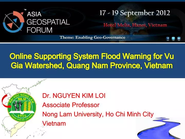
Online Supporting System Flood Warning for Vu Gia Watershed, Quang Nam Province, Vietnam. Dr. NGUYEN KIM LOI Associate Professor Nong Lam University, Ho Chi Minh City Vietnam. Content. Vu Gia watershed p roblem s. Study area description. Climate Trend in Quang Nam province.

E N D
Online Supporting System Flood Warning for Vu Gia Watershed, Quang Nam Province, Vietnam Dr. NGUYEN KIM LOI Associate Professor Nong Lam University, Ho Chi Minh City Vietnam
Temperature trend in Quang Nam province Source: SEA-START Center, RCCC-NLU, Dragon Inst.
Rainfall trend in Quang Nam province Source: SEA-START Center, RCCC-NLU, Dragon Inst.
Objectives Determine vulnerability flood area and peak flooding in Vu Gia watershed Build the online website support information about hydrometeorology at real-time Support farmer in vulnerability flood area by SMS message
Data Collection Nguyen Kim Loi 9 9/27/2014
Model Philosophy Readily available input – Physically based Computer efficient Comprehensive – Process Interactions Simulate Management
Precipitation Evaporation and transpiration Run off to streams Generated stream flow Infiltration Return flows Losses to deep groundwater SWAT Data required to set-up SWAT Model Spatial Data • Digital Elevation Data • Land use /Land cover map • Soil classification map Reservoir Data Crop Data • Reservoir characteristics • Release data • Crop calendar
Precipitation Evaporation and transpiration Run off to streams Generated stream flow Infiltration Return flows Losses to deep groundwater Data required to set-up SWAT Model Time Series Data Weather Data • Maximum / Minimum Temperature • Solar radiation • Wind speed • Relative humidity • Rainfall • Evaporation (including the locations of stations) Hydrological Data • River flow for calibrating the model
SWAT model Input Data Processing and Display DEM SWAT Databases Watershed Delineation Parameterization Hydrography HRU Definition Run Editing Calibration SWAT Model Land Use Validation Soils Weather Stations Output Weather
Methodology • Designing the real-time meteorology & hydrology data collector Temperature sensor Meteorologycollector The collector center Humidity sensor PW GSM/3G SMS Rainfall sensor • Functions: • 1. Collect temperature, rainfall, humidity • 2. Transmit data to server by GSM/3G • 3. Automatically data processing
Methodology • Designing the real-time meteorology & hydrology data collector Hydrologycollector The collector center PW GSM/3G SMS Water discharge sensor • Functions: • 1. Collecting water discharge, water level data • 2. Transmit data to server by GSM/3G • 3. Automatically data processing Water level sensor
Methodology • Updating data in real-time on website
GSM Internet Reporting and transmitting the result Processing Unit (collect and process raw data) SWAT & HEC-RAS Internet Software receive data from remote stations Processing Unit (transmit data via GSM/ 3G) Diagram of Information Processing Data sensors The software displays processing results: The package will deliver results from SWAT to handle user data such as websites, SMS and online communication on the server as well as via the cellular network Sensors directly connected to the Processing Unit • SWAT Model • Analysis of online data • Combining the data collected • Display information as map • For the final result is flooded areas (time, water level) • Export data via the information system outside • Software to collect and synthesize data center: • Receive data transmitted from the station • Data analysis by time period • Transfer data to a database of specialized software • Processing unit to support transmitting using GSM/3G: • Software to collect data • - Transiting data to the center • - Receive remote commands to allow the system changing working modes in different situations Processing unit - Raw data collection - Process, transmit to the center in case the system has noticeable changes - Processing unit receive command remotely to allow the system to be controlled via internet / GSM
Expectation • A flood warning system via internet and SMS message • Real-time meteorology & hydrology data can be used in future researches • Database, analyses and reports • Digital map of the area • Devices • Online geo-database • Website given online information • Solutions
Contribution of the Project • The real-time support for flood warning system helps to minimize losses (human life and possessions) in flash flood in the watershed. • The Research Team hopes that this project is the starting point for building an Early Flood Warming System. • GSM has covered almost all areas in Vietnam. Our system has been given possibility to integrate the system to any remote areas of the country. • The website allows update information. The users are provided web interface to see current rainfall, water lever at the watershed origin… The online changes of flood information are recorded and showed on the website. The information is valuable for residents. The data is even more valuable for officers / decision makers in the real cases.
Contribution of the Project • Data of several years is valuable input to generate flood warning function for each research location. • The system will calibrate, update parameters based on calculating information and real data. The system will alter parameters so that the warning as close to the physical case as possible. • The research result can be transfer to sever provinces/ cities. • The project is a corporation of several different faculties/ majors (GIS, Information Technology, Mechanical Engineering, Natural Resource & Environment, Hydrology and Fishery.
The Social Efficiency • Once the research is approve, the data processing system provide residents with valuable to reduce their loss in flash flood every years • The system give valuable information for decision makers in macro operations • The system give valuable information for hydroelectricity factories in the watershed • The system increase mindsets of deforestation since the rainfall, water level .. information are updated regularly on the website
Possibility to apply in real cases • 100% of the project is performed by Vietnamese researchers. • We can transfer the idea with very low price, flexibility and extendability.
Primary results • Automatic Weather Stations
Primary results • Updating weather data in real-time on website http://gislab.hcmuaf.edu.vn/vugia/
CONCLUSIONS • This research is just the first step apply SWAT and HEC-RAS model in Vu Gia watershed. The SWAT model performed well in simulating the general trend of surface runoff at watershed over time for secondly, hourly, daily, monthly time intervals. This paper provides an insight of how the HEC-RAS model can be a useful tool for providing important information about river flow fluctuations affected by extreme rainfall events. Future studies are needed to evaluate with more detail each land management practice. Work is still in progress to improve SWAT and HEC-RAS data bases to Vu Gia watershed, Quang Nam province, Vietnam - tropical conditions.
ACKNOWLEDGEMENTS The authors acknowledge the MOST (Ministry of Science and Technology) funded “Online Supporting System Flood Warning for Vu Gia Watershed, Quang Nam Province, Vietnam ” project for funding this research. Nguyen Kim Loi