Download
1 / 44
510 likes | 736 Views
River environments. Miss parson – Allerton Grange School. Aims and objectives. To recap and refresh the memory regarding the hydrological cycle To be able to recognise and label key features of a drainage basin To understand that a drainage basin works as a system

E N D
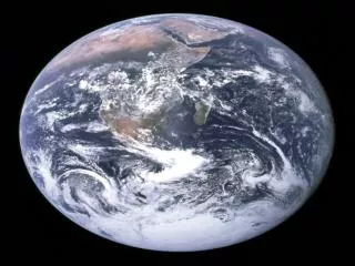
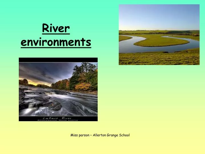
River environments Miss parson – Allerton Grange School
Aims and objectives • To recap and refresh the memory regarding the hydrological cycle • To be able to recognise and label key features of a drainage basin • To understand that a drainage basin works as a system • To understand the processes at work in a river that create the different environments • To be able to identify upland river environments • To be able to identify lowland river environments
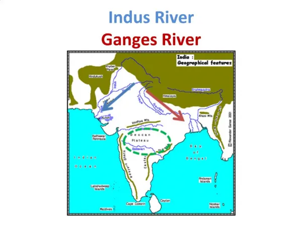
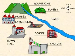
Drainage Basins A river basin is an area of land drained by a river and its tributaries. River basins have typical features, these include: Tributaries - smaller rivers flowing into the main channel. A Watershed - an area of highland surrounding the river basin. A confluence - where a river joins another river. Source - The start of a river. Mouth - Where a river meets the sea or an ocean.
Drainage basin working as a system A drainage basin works as a system, it is part of the hydrological cycle (water cycle) but it is an open system (water can be lost from it). Inputs Flows Stores Flows Stores Flows Flows outputs
Drainage basin system Transpiration Soil moisture storage
Drainage basin system • INPUTS Water enters the system as precipitation • OUTPUTS Water is lost from the system, goes out to sea via a river or through evapotranspiration • STORES Place where water is held on the surface, soil or underground • TRANSFERS/FLOWS Water moves through the system, for example infiltration, surface run-off
River processes EROSION TRANSPORTATION DEPOSITION • Let's first make sure that we understand what the process oferosion is all about.Erosion is the process whereby a river wears the land down through the moving ortransportingof smaller rock particles and debris across that land. • If the land over which the river flows is steep and the river channel holds a lot more water, the river will flow faster, if the river is flowing faster it will be able to transport more material and therefore erode its bed and banks more quickly. • The river also deposits material on the land. In other words, the river lays debris down, changing how the land surface looks. • When the land becomes flat the river will start to flow more slowly, it loses most of the energy it had - it is no longer able to carry the load of material - and will therefore deposit it.
Erosion These erosion processes obviously take a long time to shape the land and they are difficult to observe. But the land will wear down more quickly if the rocks around the river channel are softer and have more cracks. Processes of erosion Hydraulic action Corrasion Corrosion Attrition
Hydraulic action When the sheer force of the water in the river dislodges particles for the rivers bed and banks
Corrasion When smaller material carried in suspension rubs (like sandpaper) against the banks of the river.
Corrosion When acids in the water dissolves the rocks (such as limestone).
Attrition Boulders and other material are transported along the bed of the river, these collide and break in to smaller pieces.
Task 1 : Drainage basins and processesof river erosion Write a definition for each of the 4 processes of erosion. Underneath draw a series of diagrams to show how the process works. Make you diagrams clear, simple and ensure they are labelled. Hydraulic action Corrasion Corrosion Attrition
Transportation When a river carries material this is called the load. The river transports its load by a possible 4 processes Processes of transportation Traction Saltation Suspension Solution
Traction Traction: The largest rocks in the river are rolled along the bottom of the river by the force of the water. This primarily occurs in the upper reaches of the river.
Saltation Saltation: Smaller rocks are bounced along the riverbed in a leap frog motion. This occurs in the upper and middle sections of the river in general.
Suspension Suspension: The water carries smaller particles of material. This process occurs throughout the course of the river, but increases the closer you are to the mouth of the river.
Solution Solution: Material is dissolved within the water and carried along by it. Primarily this occurs in the middle and lower reaches of the river.
Task 2 : Processesof river transportation Write a definition for each of the 4 processes of transportation . Underneath draw a series of diagrams to show how the process works. Make you diagrams clear, simple and ensure they are labelled. Traction Saltation Suspension Solution
Upper course : Waterfalls Rapids ‘V’shaped valleys Interlocking spurs River profile Middle course : Meanders Floodplains Levees Lower course : Meanders Deltas Floodplains Levees
Erosion, transportation and deposition changes along the Rivers profile
Task 3 : Processes change as we move down its course Using the framework on your worksheet summarise in your own words how the processes of erosion and transportation vary from the upper course of the river to the lower course.
Upper course : Waterfalls Rapids ‘V’shaped valleys Interlocking spurs Landforms in the upper course Steep, fast flowing river, little water, lots of erosion
River landforms in the upper course V-shaped valleys and Interlocking spurs
V-shaped valleys and Interlocking spurs • The slope of the river is steep as it flows through the mountains. • The result is a fast flowing river. • If you think about the previous lesson on river processes, you should realise that this energetic river is now going to be doing a lot of erosion. • As the river is flowing so fast, it erodes downwards into the bed. • The valley will now deepen, becoming steep and V-shaped.
River landforms in the upper course Waterfalls and rapids
Formation of waterfalls Water flows over hard rock. When it reaches the soft rock, the water starts to erode or wear away the soft rock. Over thousands of years, the soft rock is eroded and the river begins to cut down vertically into the rock. This makes a cliff over which the water can topple. Over time, the cliff becomes steeper and deeper and a waterfall is formed. At the bottom of the waterfall a plunge pool is created. Some of the water splashes onto the cliff behind causing undercutting. Eventually the rock about will become unstable, collapsing and causing the waterfall to retreat.
Formation of rapids Rapids form in a similar way to waterfalls. The river bed drops down steeply, but not as a cliff, otherwise a waterfall would form. Rapids can often be found above waterfalls where the river bed is starting to drop. Rapids form a layer of hard rock on the river bed.
Task 4 :Upper course, waterfalls and rapids Now use your own words to describe the processes involved in the development of a waterfall and rapids, use the box to create a diagram with labels to help explain. Key words : Plunge pool, hydraulic action, undercutting, corrasion, retreat, hard and soft rock, collapse, attrition.
River landforms in the lower course Lower course : Meanders Deltas Floodplains Levees Gentle gradient, lateral erosion
River landforms in the lower course Meanders and oxbow lakes
Imagine a meandering river it is constantly changing shape. As the water approaches the bend it is thrown to the outside. The water is faster flowing and there is greater erosion here. The channel is deepened and a small river cliff may form. However on the inside of the bend it’s a different story. The velocity slows down and deposition occurs as the water can no longer carry its load. A point bar maybe created. Formation of meanders
Formation of oxbow lakes If the meander continues to erode an oxbow lake will form. This happens when the neck of the meander erodes so close the water breaks through, it takes the shortest route, no longer going around the bend. The river deposits material at the sides cutting of the bend
River landforms in the lower course Floodplains and levees
Floodplain Flood Plain – The Flood Plain is the area of alluvial deposits found beside the river in its lower course (often used for agriculture). As meanders move slowly down the course of the river they erode away the valley to create a wide valley floor, and they deposit layers of alluvial material on the slip off slopes.
Levee’s Levee’s – Levees are naturally formed banks along the sides of a river channel in its lower course, as it flows through the flood plain. They are formed by the river depositing material when it floods. During a flood the river deposits its heaviest, coarsest material closest to its normal course. The finer material is deposited across the valley floor, creating fertile farmland.
Deltas Deltas – Deltas occur where a river that carries a large amount of sediment meets a lake or the sea. This meeting causes the river to lose energy and drop the sediment it is carrying. An example is the Nile Delta in Egypt.
River landforms change from source to mouth Complete a summary table to show how the features change from source to mouth
Task 5 : Now use your own words to describe the processes involved in the development of meanders, oxbow lakes, floodplains, levees and deltas , create diagrams with labels to help explain. Hint : There are many erosion and transportation processes involved here so use relevant ones, look back over your work. Think about flow of the water and where deposition is occurring.
Summary • The hydrological cycle is a closed system, key terms include evapotranspiration, condensation, precipitation, surface run-off, groundwater and stores (this is a closed system). • A drainage basin also works as a system, it has inputs-flows-stores and outputs (it is an open system). • The key features of a drainage basin are the source, tributaries, confluences, watershed and mouth. • There are 4 main processes of erosion ( hydraulic action, corrasion, corrosion, attrition ). • There are 4 main processes of transportation (traction, saltation, suspension, solution).
Summary • Upland river environments include V-shaped valleys, interlocking spurs, waterfalls and rapids. • Lowland river environments include meanders, oxbow lakes, floodplains, levees and deltas. • All these features are created by fluvial processes of erosion, transportation of material and deposition. • Other factors that effect river landforms are the geology of the area (type of rock), discharge levels and human influence.
Re do diagram slide 37, 33,4,6,25 and 26 (same diagram) http://www.flickr.com/photos/dgeezer/378697598/ - picture slide 1 http://www.flickr.com/photos/thinkingtipi/1878632/ - slide 3 http://www.flickr.com/photos/55287128@N00/235175615/ - slide 7 http://www.flickr.com/photos/raggioblu/2123810860/ - slide 7 http://www.flickr.com/photos/swvirginiadeity/2369932276/ - slide 7 http://www.flickr.com/photos/daveward/52100167/ - slide 7 http://www.flickr.com/photos/matilde/307512122/ - slide 10 http://www.flickr.com/photos/chrysti/2253372678/ - slide 11 http://www.flickr.com/photos/84265607@N00/2735205592/ - slide 12 http://www.flickr.com/photos/omnia/388456312/ - slide 13 http://www.flickr.com/photos/omnia/117888350/ - slide 16 http://www.flickr.com/photos/bocavermelha/488435693/ - slide 17 http://www.flickr.com/photos/aevar/2822832530/ - slide 18 http://www.flickr.com/photos/magicbean/194767216/ - slide 19 http://www.flickr.com/photos/matthewphx/218891253/ - slide 25 http://www.flickr.com/photos/loose_grip_99/460394085/ -slide 26 http://www.flickr.com/photos/dirgon/446839052/ - slide 27 http://www.flickr.com/photos/dario_471/210986563/ - slide 27 http://www.flickr.com/photos/bjurman/2603656263/ - slide 28 http://www.flickr.com/photos/topper1/2986283732/ - slide 29 and 1 http://www.flickr.com/photos/20973954@N07/2884142843/ - slide 32 http://www.flickr.com/photos/tomfurst/1276756155/ - slide 32 http://www.flickr.com/photos/kentmercurio/2801840408/ - slide 32 http://www.flickr.com/photos/28016468@N06/2611526671/ - slide 34 http://www.flickr.com/photos/peteredin/2783891782/ - slide 35 http://www.flickr.com/photos/junesbugs/265317624/ - slide 35 http://www.flickr.com/photos/slake/1269447822/ - slide 36 http://www.flickr.com/photos/earball/1438576484/ - slide 38 http://www.flickr.com/photos/donriddle/2911619020/ - slide 39