Download
1 / 35
350 likes | 509 Views
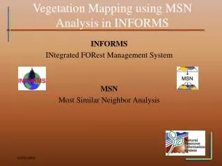
NEPA Analysis using INFORMS. INFORMS INtegrated FORest Management System Resource Management Tools and Geospatial Conference 2005. Overview. Use MSN to create a current wall to wall vegetation layer utilizing NRIS FSVeg, DEM and Landsat data.

E N D
NEPA Analysis using INFORMS INFORMS INtegrated FORest Management System Resource Management Tools and Geospatial Conference 2005
Overview • Use MSN to create a current wall to wall vegetation layer utilizing NRIS FSVeg, DEM and Landsat data. • Utilize the Forest Vegetation Simulator (FVS) to grow stand data to current and future year conditions. • Create alternatives and model vegetation treatments (i.e. thinning) for NEPA analysis and impacts evaluation.
Definitions NRIS INFORMS A project-level landscape analysis framework. NRIS FSVeg Forest Service Field-Sampled Vegetation database. Forest Vegetation Simulator (FVS) An individual-tree, distance-independent growth and yield model. Most Similar Neighbor (MSN) A powerful application used to impute available ground-based inventory data to non-inventoried units. Stand Visualization System (SVS) Visualize time-step data on a stand by stand basis. Fire Area Simulator (FARSITE) A fire spread simulator.
Data Requirements • FSVeg stand exam data • Local stand coverage (which relates to the data in the FSVeg database) • FVS Fire and Fuels Extension Variant File • Most Similar Neighbor analysis (optional) • Required for FARSITE analysis. • There are additional data requirements for Most Similar Neighbor analysis.
Process Overview • Running MSN and Creating the No Action Alternative • Alternative Building • Evaluating Alternative Impacts • INFORMS Prescription Definition • Summary
1. MSN and Creating the No Action Alternative
What is MSN? • The Most Similar Neighbor (MSN) application is a powerful tool used to impute available ground-based inventory data to non-inventoried units. • The MSN method uses available data from the ground-based sample units and globally available data measured on all sample units to guide the imputation. • Examples of global information known about all sample units include topographic data and satellite imagery. • Landscape of vegetation data is available for analysis based on imputations from the MSN process.
MSN Forest Vegetation Quality Gray = Reference (sampled) stands Green = OK Quality (Imputed) Red = Poor Quality (Imputed) Yellow = Non-Veg (rocks, lake, etc.) Brown = Non-Forest (grass, shrubs, etc.) A report is also created summarizing the key elements of the MSN run.
Base FVS Vegetation Layer The results from FVS and MSN are used to generate current and future vegetation layers for each decade in the simulation. Each layer contains information such as basal area, stand height, qmd, canopy cover and more.
Vegetation Layer The results from FVS and MSN are used to generate current and future vegetation layers for each decade in the simulation. Fuel Model – Same Year With MSN Without MSN
Creating No Action Alternatives Basal Area No Action Plus Disturbance No Action
Fire Intensity Maps 2005 2045
FRCC - Seral Class 2045 2005
Alternative Building in INFORMS • Vegetative future conditions are created by defining alternatives and applying vegetative treatment prescriptions. • There are three methods for applying prescriptions to a stand or a portion of a stand. A tool is available to split a stand. • If MSN analysis is used, prescriptions can be applied to imputed stands (stands which do not have a stand exam in FSVeg). • Treatments are applied through FVS keyword files. This changes future condition vegetative values.
Prescription Assignment:GIS overlay • Create a GIS Area Prescription Set layer (essentially a layer with codes inferring where a prescription should be assigned) • Create a GIS Area Prescription Set Definition • Overlay the prescription set layer with the stands coverage
Prescription Assignment:GIS overlay – Set Layer Prescriptions for each set polygon: UNIT-A: - PP_HIGH &- PILE_BURN UNIT-B: - THRESHOLD UNIT-C: - MC_HIGH
Evaluating Impacts for Alternatives • The results of the prescription treatments from FVS are used to generate current and future vegetation data for each decade in the simulation. • The ‘treated’ alternative layers contain treated and untreated stands for the complete analysis area. • This allows for comparison of effects between the no action and treatment alternatives at different time steps.
Examples – Alternative Evaluation • Current year comparison: • Burn Model • FARSITE • Fire Regime Condition Class (FRCC) • Vegetation Structural Stage (VSS) (Region Specific) • Future year comparison: • Burn Model • Fire Regime Condition Class (FRCC)
Basal Area Before and After Treatment – Same Year Burn Simulation Treatment No Treatment
Risk Map Before and After Treatment – Same Year No Action Alternative A
No Action Alternative A • No Action – 457ha burned After Treatment – 391ha burned FARSITE Before and After Treatment – Same Year
Burn Model No Action Treatment 2045 2005
INFORMS Prescriptions • Prescriptions, as used in INFORMS, are a collection of FVS keyword files which can be assigned to stands. • INFORMS uses FVS to modify the vegetative landscape to represent alternative future conditions. • Sources of FVS keyword files: • Many regions are creating standard keyword files • Forest Health is creating keyword files for modeling pest impacts • Local FVS users can create their own keyword files
Fuels Analysis Process FSVeg Data Sampled Vegetation and Fuels Data FVS/FFE Most Similar Neighbor (MSN) DEM & Landsat Wall-to-Wall Current Vegetation and Fuels Data Legend: Yellow = Inputs Blue = Outputs Green = Models Treatment Alternative FVS/FFE Wall-to-Wall Future Years Vegetation and Fuels Data (No Action and Alternative) Fire Area Simulator (FARSITE) Stand Visualization System (SVS)
Summary • INFORMS and MSN currently provide a methodology for vegetative treatments and fuels analysis. • INFORMS provides the ability to produce multiple alternatives for various treatment scenarios. • MSN provides the ability to do landscape-level fuels analysis (i.e. fire spread). • MSN accuracy assessments are currently being developed (2005) to provide ID teams with more defensible results.
Cooperators • Rocky Mountain Research Station (Nick Crookston & Al Stage) • Forest Pest Management (Carol Randall & Jim Stone) • Region 3 Fire & Fuels (David Martinez) • Los Alamos National Laboratory • Texas A&M (USDA Risk Management Agency) • Mescalero Apache Reservation
For More Information • Eric Twombly – Project Leader • Lynne Bridgford – GIS Developer • Jonathan Marston – Oracle Developer Web: fsweb.nris.fs.fed.us/products/INFORMS