Download
1 / 24
260 likes | 481 Views
ArcCatalog and Geodatabases. Francisco Olivera, Ph.D., P.E. Srikanth Koka Department of Civil Engineering Texas A&M University. ArcCatalog. ArcCatalog is one of the three components of the ArcGIS software. The other two are ArcMap and ArcToolbox.

E N D
ArcCatalog and Geodatabases Francisco Olivera, Ph.D., P.E. Srikanth Koka Department of Civil Engineering Texas A&M University
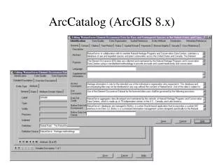
ArcCatalog • ArcCatalog is one of the three components of the ArcGIS software. The other two are ArcMap and ArcToolbox. • ArcCataloghas advanced capabilities for accessing, managing and previewing data.
Main menu Standard toolbar View Type Catalog Tree Display Preview Type View Types • There are three different types of views for data display: • Contents • Preview • Metadata
Folder Connection • To access the data in a folder or geodatabase, a connection has to be established. • To establish the connection, click on the Connect to Folder button. • In the Connect to Folder wizard, navigate to the folder or geodatabase that contains the data and click OK.
Preview Table Preview Geography Preview
Metadata • The metadata view in ArcCatalog can be used for viewing information about the data. • Metadata can be created, edited, imported or exported using the Metadata toolbar.
Geodatabase • A geodatabase is a relational database that contains spatial and non-spatial objects.
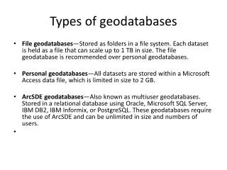
Types of Geodatabases • Personal Geodatabases: • Have .mdb extension. • Can be viewed by multiple users but edited by only one user at a time. • Have a maximum size of 2 Gigabytes. • Do not store raster data. • Multi-user Geodatabases: • Require ArcSDE and a DBMS ( Data Base Management Systems). • Can be read and edited by multiple users at the same time. • Can store raster data.
Personal Geodatabases • Importable Data Types: • Coverages • Shapefiles • CAD drawings • INFO tables • DBF tables • Can be opened with ArcCatalog and MSAccess.
Geodatabase Elements Workspace Geodatabase Feature Dataset Feature Class Geometric Network Relationship Class Table
Feature Class • A feature class is a collection of geographic objects in tabular format that have the same behavior and the same attributes. All feature classes have a field named “Shape.” • A feature class can be stored at the geodatabase root or in a feature dataset. • New feature classes can be created using ArcCatalog. To do this, right click on a geodatabase or feature dataset, and point to New/Feature Class.
Annotation Line Point Polygon Feature Class Types
Tables • A table (or object class) is a collection of non-spatial objects in tabular format that have the same behavior and the same attributes. All object classes have a field called “ObjectID,” sometimes also called FID or OID. • Tables can be stored at the root level of geodatabases but not inside feature datasets. • Table format supported: INFO, dBase and others.
Attribute Domain • Attribute domains are used to constrain the values allowed in any particular attribute of a table or feature class. • There are two different types of domains • Range Domains • Define a range of acceptable values for an attribute • Coded Value Domains • Define a set of acceptable values for an attribute
Domain Properties • Field Type: Text, short integer, long integer, double, date, etc. • Domain Type: Coded values, range • Split policy: Duplicate, default or geometric ratio • Merge policy: Default, sum, weighted average
Subtype • Subtypes are subsets of feature classes and tables. • Objects in a class can be differentiated based on attribute values attached to the features. • Example: A feature class that represents roads can have two types of roads - US Highway and Interstate. Each type forms a class subtype.
Feature Dataset • A Feature Dataset is a collection of feature classes that have the same spatial reference. • Feature datasets can also store relationship classes and geometric networks, but not tables. • New feature datasets can be created using ArcCatalog. To do this, right click on a geodatabase, then point to New/Feature Dataset.
Feature Dataset Properties • The Feature Dataset Properties wizard can be used for viewing or defining a feature dataset’s spatial reference properties.
Relationships • A Relationship is an association or link between two objects in a database. • A relationship can exist between spatial objects (features of feature classes), non-spatial objects (records of tables), or between spatial and non-spatial objects.
Relationships Relationship between non-spatial objects State Name and code State Population
Spatial data Relationships Relationship between spatial and non-spatial objects Non-spatial data
Spatial data Spatial data Relationships Relationship between two spatial objects
Relationship Class Relationship Class • A relationship class is an association between two object classes (i.e., feature classes or tables). • Relationships can be one-to-one, one-to-many or many-to-many. • Can be created and edited using ArcInfo or ArcEditor only, but can be accessed with ArcView. • Can be inside or outside feature datasets.
References • Mac Donald, “Building a Geodatabase”, Environmental Systems Research Institute (ESRI), Redlands, Calif • http://www.ce.utexas.edu/prof/maidment/giswr2003/visual/lecture22003.ppt • http://mark.gisc.kennesaw.edu/4405/Geodatabase.pdf • http://visc.sis.pitt.edu/resources/tutorials/GIS/Geodatabases.pdf • http://www.gis.state.ar.us/Downloads/GIS/presentations/Geodatabase%20101.pdf