Download
1 / 19
190 likes | 377 Views
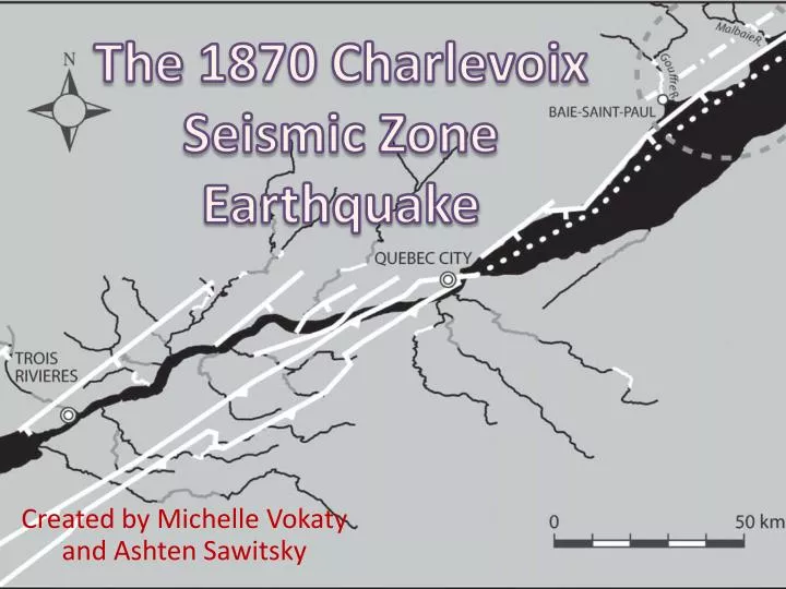
The 1870 Charlevoix Seismic Zone Earthquake . Created by Michelle Vokaty and Ashten Sawitsky. Overview . Tectonic setting Canadian/Quebec/CSZ Earthquakes Charlevoix Seismic zone and location Geology Sediment control Mercalli Scale Relationship of Magnitudes

E N D
The 1870 Charlevoix Seismic Zone Earthquake Created by Michelle Vokaty and Ashten Sawitsky
Overview • Tectonic setting • Canadian/Quebec/CSZ Earthquakes • Charlevoix Seismic zone and location • Geology • Sediment control • MercalliScale • Relationship of Magnitudes • Historic, type, causes and effects of CSZ Earthquakes
Charlevoix Seismic Zone (CSZ) • 100 km from downstream Quebec City • Most seismically active region in Eastern Canada, defined by over 2000 local earthquakes between 1978 and 1997 • Detectors record over 200 quakes a year • Dominated by earthquakes along and in between the Iapetanfaults (or otherwise known as the St.LawrencePaleo-rift faults) • Most activity occurs along the St. Lawrence valley
Historic Causes of CZS Quakes • Four major events that are the cause for these earthquakes • Grenvilliancollision (110-900 Ma) • Rifting due to opening of the Iapetus Ocean (700Ma) • Then the reactivation of these faults when Iapetus stared closing during Taconian Orogeny (450 Ma) • Finally, the Devonian Meteor impact (350 Ma) • One controversial theory: Conditions such as high pore fluid pressure and/or low coefficient of friction must exist that do not exceed the maximum crustal stress differences
Location of 1870EQ in Seismic Zone • Quebec city is rated 6th for earthquake risk and 1st or 2nd for damage • Strong earthquakes with epicenter distances between 0-80km
Geology of Zone • Four main geological assemblages • The Precambrian shield of Grenvillian age with charnockite-mangeriteassembleges, metasediments, anorthositeintrusives and local gabbro dykes within the fault zones • OrdivicianSt. Lawrence platform- predominantly limestones • Appalachian nappes- Cambrian sedimentary rocks (sandstones, mudstones) which is thrust over the previous two • Quaternary deposits- usually glacial till and marine clays and valleys filled with multi-interglacial sedimentary sequences
Sediment controls • Sand, clay, unconsolidated manmade sediment • Thickness of 5-30m • Thick deposits • Long period • More shaking • Most damage • Rivers affect the area 1950 • Spring and Fall
Modified mercalli scale • 12 increasing levels of intensity • Imperceptible shaking to catastrophic destruction • Arbitrary ranking based on observed effects • Effects experience at the place • Higher numbers=structural damage, lower number=felt by ppl
Types of Earthquakes • High quality records used to study focal mechanisms, earthquake clusters and crustal velocities • Earthquakes occur within the Precambrian lithology’s • Upper to mid-crustal thrust strike-slip events • No conclusive reasons/pattern for earthquakes
Earthquakes in history • 1663 • M7, epicenter in CSZ, landslides • 1791 • M6, Felt in Quebec City • 1860 • M6, epicenter in CSZ • 1870 • M6.5, felt in Quebec City • 1925 • M6.2, epicenter in CSZ, damage in Lower Town • 1988 • M5.9, MMI = V-VII
Factors of earthquakes • Earthquake source (magnitude, focal depth, epicenter distance • Characteristics of inhabited area (distribution of inhabited areas, characteristic of building stock, thickness and properties of underlying material • Most damage in deep unconsolidated sediment (lower part of town) • Natural deposits and manmade fills are thickest • Saint-Roch and Champlain wards effected • Short epicenter distance=more damage
1870 Geological/Economic Effects • Caused geysers of water and sand • Possibly relates to a sand volcano in Gouffre River Valley • Only 1989 M 6.3 caused surface faulting, • some say some offshore surface faulting could have occurred, although hard to see/record during that time-recent seismic data report negative results • Few indirect casualties such as heart attacks, but more structural damage • Possible geological effect is liquefaction
Bibliography • John E. Ebel, M. D. (2013). Assessing the Location and Magnitude of the 20 October 1870 Charlevoix, Quebec, Earthquake. Seismological Society of America, 588-594. • Lamontagne, M. (2002). An Overview of Some Significant Eastern Canadian Earthquakes and Their Impacts on the Geological Environment, Buildings and the Public . Natural Hazards , 55067. • Lamontagne, M. (2008). Earthquakes in Eastern Canada: A Threat that can be Mitigated. Natural Resources Canada, 13-23. • Lamontagne, M. (2009). Description and Analysis of the Earthquake Damage in the Quebec City Region between 1608-2008. Natural Resources Canada, 514-524. • Lamontange, M. (1999). Rheological and Geological Constraints on the Earthquake Distribution in the Charlevoix Seismic Zone, Quebec, Canada. Natural Resourses Canada. • Lamontange, M. (2008). Casualties Directly Caused by an Earthquake in Canada: First Contemporaneous Written Accounts from the M 6.5 Charlevoix, Quebec, Earthquake of 20 October 1870. Seismological Society of America, 1602-1606.