Download
1 / 15
150 likes | 256 Views
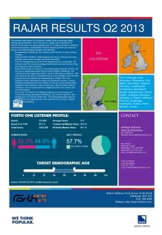
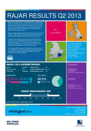
Q2 Description, Results, and Plans. Jian Zhang Hydrometeorology. Q2 System Overview Flowchart. Radar. Quality Control. Satellite. 3-D Radar Mosaic. QPE. QPF* (0-2h). Rain Gauge. Model. Precip Products. Mosaic Products. Sfc Obs & Sounding. Verification. Users. Lightning.

E N D
Q2 Description, Results, and Plans Jian Zhang Hydrometeorology
Q2 System Overview Flowchart Radar Quality Control Satellite 3-D Radar Mosaic QPE QPF* (0-2h) Rain Gauge Model Precip Products Mosaic Products Sfc Obs & Sounding Verification Users Lightning NSSL Laboratory Review February 17-19, 2009
Q2 Components • Reflectivity quality control (QC) (Lakshmanan et al. 2007, JTECH; Gourley et al. 2007, JTECH) • 3-D reflectivity mosaic (Zhang et al. 2005, JTECH; Langston et al. 2007, JTECH; Yang et al. 2009, AAS) • Precipitation classification (Xu et al. 2008, J. Hydromet; Zhang et al. 2008, JTECH) • Stratiform, Convective, Hail, Tropical Rain, and Snow • Adaptive Z (reflectivity) - R (rainfall rate) relationships (Xu et al. 2008, J. Hydromet) • Seamless hybrid scan reflectivity (HSR) mosaic • Local gauge bias correction (in preparation) • Vertical profile of reflectivity (VPR) correction for bright band (Zhang et al. 2008, JTECH) • Non-standard blockage mitigation (Chang et al. 2009, JTECH) • Multi-sensor quantitative precipitation estimation (QPE) uncertainties NSSL Laboratory Review February 17-19, 2009
Automated Reflectivity Quality Control Objective: to remove non-precipitation echoes. Performance: >95% Remaining challenges: nocturnal AP + migrating birds. Future: dual-pol hydrometeor/scatterer classification Before QC After QC Publications: Lakshmanan, V., A. Fritz, T. Smith, K. Hondl, and G. J. Stumpf, 2007: An automated technique to quality control radar reflectivity data. J. Appl. Meteor., 46, 288–305. Gourley, J.J., P. Tabary, and J. Parent-du-Chatelet, 2007: A fuzzy logic algorithm for the separation of precipitating from non-precipitating echoes using polarimetric radar observations. J. Atmo. and Ocean. Tech., 24, 1439-1451. NSSL Laboratory Review February 17-19, 2009
3-D Reflectivity Mosaic Objective: depict high-resolution 3-D storm structure Performance: transferred to operations at NCEP and improved short term precipitation forecast; part of the FAA’s “Weather Cube” Remaining challenges: low vertical resolution Future: Phase Array Radar will provide better vertical resolution Dallas Hail Storm 5/5/95 Publications: Zhang, J., K. Howard, and J.J. Gourley, 2005: Constructing three-dimensional multiple radar reflectivity mosaics: examples of convective storms and stratiform rain echoes. J. Atmos. Ocean. Tech., 22, 30-42. Langston, C., J. Zhang, and K. Howard, 2007: Four-dimensional dynamic radar mosaic. J. Atmos. Ocean. Tech., 24, 776-790. NSSL Laboratory Review February 17-19, 2009
Radar Reflectivity Different drop size distributions => different Z-R relationships. Radar measurement (reflectivity) is not directly related to precipitation at the surface, but rather to the drop size distribution in the clouds. Empirical relationships are usually used to derive precipitation rate (R) from reflectivity (Z). Precipitation Classification Radar QPEPrecipitation Classification Objective: To obtain accurate, high-resolution precipitation estimation. NSSL Laboratory Review February 17-19, 2009
Convective/Stratiform/Hail Need more surface validation data => Severe Hazards Analysis & Verification Experiment (SHAVE) project Radar Reflectivity Precipitation Classification Publications: Zhang, J., C. Langston, and K. Howard, 2008: Bright Band Identification Based On Vertical Profiles of Reflectivity from the WSR-88D. J. Atmos. Ocean. Tech. 25, 1859-1872. NSSL Laboratory Review February 17-19, 2009
a b c d Tropical Rain Identification Typhoon Krosa, 10/6/07 Taiwan Publications: Xu, X., K. Howard, andJ. Zhang, 2008: An automated radar technique for the identification of tropical precipitation. J. Hydrometeorology. 9, 885-902. NSSL Laboratory Review February 17-19, 2009
1043UTC Jan.7, 2009 Rain/Snow Delineation RUC Surface Analysis Environmental data is extremely important for precipitation classification => true both for single and dual-pol radar applications! NSSL Laboratory Review February 17-19, 2009
Adaptive Reflectivity-Rainfall (Z-R) Relationships rain rate convective Reflectivity tropical Taiwan stratiform snow Pcp Type 1- and 3-h acc updated every 5-min 6- to 72-h acc (updated hourly) NSSL Laboratory Review February 17-19, 2009
Q2 Performance:Quality Control and Adaptive Z-R Q2 (research) Stage IV (operational) Stage II (operational) 24-h 12Z 4/25/07 24-h 12Z 4/25/07 24-h 12Z 4/25/07 Radar, satellite, and gauge Human intervention Radar-only, automated Radar & model, automated NSSL Laboratory Review February 17-19, 2009
Q2 Performance:Seamless Mosaic Stage IV Q2 NSSL Laboratory Review February 17-19, 2009
Correction for Non-Uniform Vertical Profiles of Reflectivity “bright band” KCLE 1-h rainfall ending10Z 11/15/08 NSSL Laboratory Review February 17-19, 2009
Future Directions • Fully integration of dual-pol radar QPE techniques • Evaluations (in collaboration with NWS/OHD, National Climate Data Center, University of Oklahoma, and NCAR) • Continued R&D on • Blockage mitigation • Non-uniform vertical profile of reflectivity correction • Local gauge bias correction • Multi-sensor (radar, model, gauge, satellite) blended QPE • Continued collaboration with NOAA/HydroMet Testbed • Integrate gap-filling radars • Refine snow line delineation • Continued collaboration with hydro modeling (Coastal & Inland FLooding Observation and Warning Project -- CI-FLOW) NSSL Laboratory Review February 17-19, 2009
Summary • Q2 is a real-time system that produces national QPE products with high- spatial and temporal resolution. • Q2 is a testbed that facilitates rapid science-to-operations transfer for hydro-meteorological applications. • Q2 has been serving many users in government agencies, universities, and private sector. • Q2 will continue R&D for advanced multi-sensor QPE. Questions? NSSL Laboratory Review February 17-19, 2009