Download
1 / 28
310 likes | 350 Views
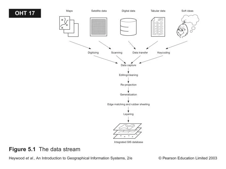
Digitizing. There are three primary methods for digitizing spatial information: Manual Methods include: Tablet Digitizing Heads-up Digitizing An Automated Method includes: Scanning and Vectorization. Manual Digitizing. Ref: Getting Started with GIS, by K. Clarke. How is it done?.

E N D
Digitizing • There are three primary methods for digitizing spatial information: • Manual Methods include: • Tablet Digitizing • Heads-up Digitizing • An Automated Method includes: • Scanning and Vectorization
Manual Digitizing Ref: Getting Started with GIS, by K. Clarke
How is it done? • Although methods vary, the typical steps for digitizing a paper map require the following: • Physical Preparation • Digitizer Set up • Map preparation • Digital Preparation • Map registration • Digital Collection • Feature collection • Feature correction • Save, save, save
Creating New Data (Cont’d) • Manual Digitizing: • Digitizing tables used (tedious process) • Electronic mesh senses cursor position • Paper maps (e.g. Topo Maps) are sources of most GIS themes that we use • Point or stream mode digitizing done • Now-a-days mainly done in 3rd world • Need to record ref. coor. converted to real-world coor. (GIS coverage) • Digitizing polygons need labels (ID) • Careful planning needed before you digitize
Heads up Digitizing • Digitizing and scanning
Scanning Ref: Getting Started with GIS, by K. Clarke
Creating New Data (Cont’d) • Scanning: • Scan a map into binary grid file • Can be converted back to vector thru tracing (i.e. line thinning extracting topo-reconstruction or smoothing) • Software available to clean scanned images • Resolution is an issue (e.g. a line = 5-6 pixels) • Digital maps are as good as the source map
Creating New Data (Cont’d) • On-Screen (head-up) Digitizing: • Relatively easy to do • Good for updating/editing changes • You can add points, lines, polygons • You don’t have to register points as in manual digitizing • Geometric Transformation: • Digitized maps have same coor. As source map • You may have to convert to real-world coor. & projection using control points.
Raster to Vector Conversion • Able Software R2V • AutoDesk Raster Design • ESRI ArcScan
Rubber Sheeting: Spatial database editing software that attempts to correct errors by stretching a map to fit known control points or monuments.
Why Topology Matters • Topology allows automated error detection and elimination • Need to build/clean topology for digitized/scanned maps • Unconnected nodes are snapped • Slivers from digitizing are eliminated • Topology makes map overlay feasible • GIS operations are done w/o accessing the point files
Why do I want Topology? Gaps and slivers Overshoots and undershoots
Non-Topology Ref: Introduction to GIS by K. Chang
Creating New Data • Remotely sensed data • Georef; 1m x 1m resolution; good as a background map for other themes Ref: Getting Started with GIS, by K. Clarke
Creating New Data (Cont’d) • GPS: differential GPS have cm-scale resolution • Measures ranges (distances of receivers by 24 NAVSTAR satellites using radio signals & atomic clocks) • Ref. or base stations can reduce noise • Diff. GPS comes w/ software to download data • Hand-held GPS data can be downloaded too Ref: Getting Started with GIS, by K. Clarke
Creating New Data (Cont’d) • Field Survey Data: • defines parcels by azimuth & distances • Uses Total Station, Stadia, Laser Ranging, and COGO software Ref: Getting Started with GIS, by K. Clarke
Methods of Collecting Data • Existing data, downloads from field • Keyboard • COGO
Creating New Data (Cont’d) • Street Addresses: • Point features, street segment length, even/odd house numbers with side descriptions (e.g. TIGER files) can be geocoded • TEXT Files: lat/long in dec. degrees cane converted to an event theme Ref: Getting Started with GIS, by K. Clarke
What is Conflation? • the process of transferring attributes from a source line layer based on one level of accuracy and precision to a target line layer of a different precision and accuracy.
Format & Exchanging of GIS Data • Can import different data formats or use utility programs (e.g Import 71) to convert data • GIS accept TIF, GIF, JPEG, AutoCAD data formats (needs right extensions) which are not georeferenced • Vector to Raster conversion is easy, opposite is hard • Data exchange by import/export involves errors in attributes & geometry • ESRI New Product called Data Interoperability • Efficient data transfer is important for the future of GIS • OpenGIS® Specifications on • GML Geographic Markup Language • WMS Web Map Service • WFS Web Feature Service