Download
1 / 10
100 likes | 216 Views
Bio-diversity Fragmentation and Conservation Nets A Pilot Project in Edmonton, Alberta Jeff Truscott Niagara College The Earth Observation Systems Lab (EOSL) The University of Alberta Earth and Atmospheric Sciences Dept.

E N D
Bio-diversity Fragmentation and Conservation NetsA Pilot Project in Edmonton, AlbertaJeff Truscott Niagara College The Earth Observation Systems Lab (EOSL)The University of Alberta Earth and Atmospheric Sciences Dept.
What is Bio-diversity?The biological diversity of a system is determined by the level of species richness and genetic variation found within the system.Why is Bio-diversity important?The biological diversity of a system can be used to gauge the overall complexity and health of a system, and therefore it’s ability to provide and maintain essential services to connected systems.In his book Land Mosaics R.T.T. Forman suggests three groupings for the values associated with the maintenance of a variety of lifeforms, or Bio-diversity:1). Food, fibre, and chemical products.2). Ecosystem services of controlling water, recycling, and cleaning the environment.3). Inspirational, Aesthetic, and Existence Values
What is Bio-diversity Fragmentation?-the reduction of native vegetation into disconnected ‘islands’What outcomes result from the Fragmentation process?-remnants may not be large enough to maintain ecological processes such as water and nutrient cycling that existed prior to disturbance-disconnection may isolate patches and prevent effective flow of genetics in and out of a patch, ultimately leading to stagnation and/or loss of species
What are Conservation Nets?Aninterconnected network of functional conservation units; a comprehensive network of patches and corridors of varying biological mediums.-parks-protected areas-green spaces -remnant patches-hedgerows-river valleys -undeveloped land-native vegetationIdeology:A combination of traditional Conservation philosophy with modern Landscape Ecological theory through the application of GIS/RS technology.
Background: Why a Conservation Nets Study for Edmonton?1) The City has recently launched a master transportation plan that includes two ring roads. Vehicle-wildlife collisions are costly if natural wildlife corridors are not designed carefully.2) Cost cutting in city maintenance budgets has resulted in more "naturalization" of green areas. These changes could be used to enhance corridor development.3) Off leash dog areas have recently been designated. Conflicts with wildlife should be considered. 4) Multiple use trails and conservation conflicts are not well studied. Trails should consider sports enthusiasts and conservation.5) City educators have always used the river valley* for teaching; yet, there is surprisingly little documentation of the environment and environmental issues in the city.*North Saskatchewan River valley (Ribbon of Green)
Project Scope:The basic hypothesis being tested is that we can identify which corridors are effective in key species movements and which characteristics of corridors restrict movements of key species.Goals:1) Identify a Conservation Net of nodes and corridors for the RIBBON OF GREEN that incorporate areas of high conservation value and to identify single and multiple corridors that link these nodes,2) Test the effectiveness of these nodes in protecting biodiversity and of these corridors to facilitate biological transfer among nodes,3) Make recommendations that will solve boundary/buffer zone and fragmentation issues using environmentally appropriate methods,4) Train at the community, secondary school, technical and university level, students who will become community-oriented educators, managers and researchers so that they can sustain Conservation Nets5) Maintain communication with local, national and international individuals and groups using high profile activities and methods.
My Involvement:Develop system to identify potential corridors using a pilot study area along the White and Black Mud Creeks, tributaries to the North Saskatchewan river (Ribbon of Green).Steps Involved:1). Using Landsat 7 (1999)satellite imagery, perform an Unsupervised Classification to identify existing areas of Biological value.2). Perform ground truth testing to verify the positive identification of areas distinguished in satellite classification.3). Perform a Supervised Classification of satellite imagery in order to isolate the desired regions.4). Create polygon coverages of isolated regions and perform spatial analysis ie. cost analysis, nearest neighbour, to identify likely corridors used for key species movements.
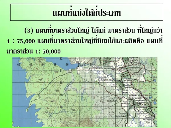
Study Area: White Mud and Black Mud Creeks 1:50,000 NTS Series 1:50,000 and 1:250,000 (1991). 1:250,000
Numeric Benefits of the application:1) Esthetic benefits gained from existing green spaces, protected areas and re-naturalized public parks positively influences residential property values.2). City of Edmonton is poised to become an international leader in sustainable, conservative planning; could increase in drawing Eco-tourist population from nearby Banff and Jasper National Parks.3) Identification and encouragement of wildlife corridors could reduce the frequency and costs of automobile related conflict. 4) Re-naturalization of landscapes reduces costs by eliminating maintenance of heavily manicured public park areas.
Secondary Objectives: (time permitting) 1). Chronological comparison of Vegetation change using digital photographs of study area (1989), provided by City of Edmonton Parks Dept. and Landsat 7 satellite imagery (1999).2). Suitability Assessment of Landsat 7 Resolution capabilities for Vegetation Classification Accuracy3). Determine accuracy enhancement for vegetation classification by resampling Landsat 7 30m by 30m resolution bands to 15m by 15m resolution Panchromatic Band.