Download
1 / 15
150 likes | 268 Views
The Role of Spatial and Temporal Variability of Pan-Arctic River Discharge and Surface Hydrologic Processes on Climate. Dennis P. Lettenmaier Jennifer C. Adam Fengge Su Department of Civil and Environmental Engineering University of Washington

E N D
The Role of Spatial and Temporal Variability of Pan-Arctic River Discharge and Surface Hydrologic Processes on Climate Dennis P. Lettenmaier Jennifer C. Adam Fengge Su Department of Civil and Environmental Engineering University of Washington Eric F. WoodDepartment of Civil EngineeringPrinceton University Freshwater Initiative All-Hands Meeting Woods Hole, MA May, 2004
Central Science Question: • How will the coupled arctic climate system respond to changes in riverine discharge of freshwater, and how do the temporal and spatial variability of freshwater discharge, and changes therein, interact with the dynamics of high latitude climate? • LSM Off-Line Simulation Goals (Task 2): • To estimate the inflow to the Arctic Ocean from all pan-arctic land areas (including the Canadian Archipelago) • To asses the capability of the land surface model to simulate the observed changes in gauged streamflow • To use the model to evaluate the effects of changes in snow cover extent and active layer depth on streamflow variability
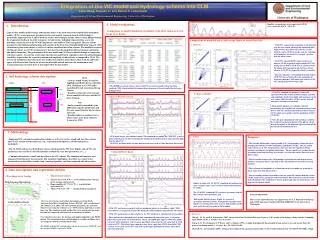
Modeling Framework Pan-Arctic Domain per ArcticRIMS 100 km by 100km EASE runs: 1979-1999, 1950-1995
Routing Model 2810 cells routed to 643 outlets Contributing Area: 25 million km2
Two Eurasian Basins Lena (at Kusur): 2,430,000 km2 RRMSE = 1.8% Bias = 11.3% Yenesei (at Igarka): 2,440,000 km2 RRMSE = 1.6% Bias = 7.9%
Two North American Basins Mackenzie (at Arctic Red River): 1,680,000 km2 RRMSE = 6.4% Bias = 35.6% Yukon (at Pilot Station): 831,000 km2 RRMSE = 5.9% Bias = -4.1% Needs further calibration/ improved forcings
Freshwater Discharge to Arctic Ocean/Hudson Bay Discharge • Varies between 5700 and 7900 km3/year • Comparisons of trends for obs. and sim. streamflow for major basins suggest that simulated trends are not believable: more work is needed for temporally homogenous precip. forcings (see poster) Trend = 19.3 km3/year2 Initialization Problem? Precipitation Trend = 11.2 km3/year2
Snow Cover Extent Comparison NOAA-NESDIS weekly snow charts VIC
Changes in Snow Cover Extent Change in number of snow days per year between the 1950’s and the 1990’s. Question: How do these changes affect streamflow variability? TBD Increasing # of Days Decreasing # of Days
Question 1: Links to and Collaboration with other FWI projects
Question 2: Links to ARCSS and Contributions to ARCSS • The various ARCSS projects provide us with the data needed to validate, evaluate, and improve our modeling system, e.g.: • Climate and Flux Data from Alaska (LAII) • Meteorological and Hydrographic Data, Kuparuk (LAII) • Variations in Circumpolar Frozen Ground Conditions (LAII-FLUX) • Arctic Global Radiation (AGR) Data Set (OAII-SHEBA) • etc… • This work will contribute to the understanding of ARCSS by providing an estimate of riverine freshwater discharge to the Arctic Ocean, a clearer understanding of how this discharge is affected by anthropogenic climate change and by what physical processes, and an improved understanding of how the variability of streamflow and other land surface states and fluxes feed back into the high latitude climate system.
Question 3: Self-Evaluation of Progress • We have 21-year (1979-1999) simulations that can reasonably reproduce observed streamflow for various large and small watersheds throughout the pan-arctic; further work is needed to improve the 46-year (1950-1995) simulations, especially in improving the precipitation forcings by making them more homogeneous in time. Once our simulated streamflow trends and variability match observed, we can begin to explore what physical processes have the greatest effect on streamflow. • We have also tested various other simulated quantities against observed including snow cover extent, snow water equivalent/snow depth, permafrost active layer depth, and radiation fluxes.
Question 4: What is limiting our knowledge of the freshwater system of the Arctic? • Discharge records can be used to determine the variability of streamflow from gauged basins, but what are the physical processes controlling this variability? This question must be answered before we can begin to explore how changes in freshwater discharge to the Arctic Ocean will feed back into climate, especially in a modeling context. It is imperative that the LSM in a coupled climate model system capture the phenomena that control streamflow variability. Therefore, we need to understand what these processes are and in order of importance, i.e. to which processes is streamflow variability most sensitive.