Download
1 / 13
130 likes | 247 Views
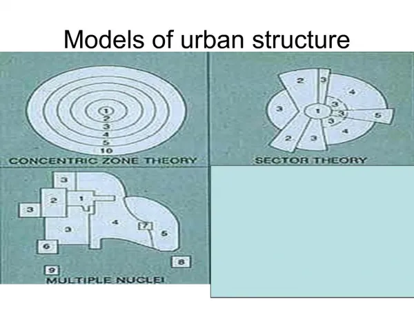
Application of urban models. Are the 3 models adequate enough to explain land use pattern in a city?. No single model alone can do. Each model has its usefulness to explain. Burgess: ecological factors concentric zones Hyott: transport routes sectoral pattern

E N D
Are the 3 models adequate enough to explain land use pattern in a city? • No single model alone can do. • Each model has its usefulness to explain. • Burgess: ecological factors concentric zones • Hyott: transport routes sectoral pattern • H&U: multiple-nuclei suburban centres
3 in 1? • Fused model • Elements of all three models are present • A centre core • Several other business districts (nuclei) around which concentric zones develop • Broken by sectors of radial growth along the main transport arteries that connect the various business districts
What does the city look like in a fused model? • A star-shaped or stellate city • Distinct economic, industrial and social zones • Developed along the axes of growth • E.g. railway lines
Which model can best describe the land use pattern in HK? • Concentric model? • Sector model? • Multiple-nuclei model? • Or a fusion of three?
Central core • CBD in Central District & TST • Separated by harbour
Sectoral development / radial growth of urban area • Along main roads, e.g. Nathan Road, Castle Peak Road, Queen’s Road • Along main railway lines, e.g. Island line northern shore of HK Island
Multiple-nuclei • Regional business district, e.g. Mongkok, Causeway Bay • Outlying business district, e.g. Shatin
Relief • The harbour divides the CBD • The hills on HK Island restrict southward urban growth • The hills in Kowloon restrict northward urban growth • Linear urban development along the limited strip of lowland on HK Island • Land obtained by reclamation / levelling of hills
Transport development • New shopping nucleations developed around or above MTR stations • Telford Gardens in Kowloon Bay • City Plaza at Tai Koo Shing • Festival Walk at Kowloon Tong
Urban dynamics • Suburbanization decentralization of population, commercial, industrial and residential land uses • Factories in Kwun Tong Tai Po Industrial Estates • Shatin / Tuen Mun new town • Tsuen Wan town centre
Government influence • Land use planning • New town planning and development • Urban renewal and redevelopment • Anti-pollution and conservation policy • Recreational land use in urban areas • Green belts
Historical factor • Lack of urban planning in the past • History of urban growth • Urban decay