Download
1 / 1
10 likes | 252 Views
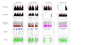
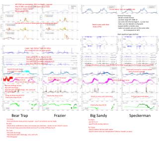
Bear Trap Met. Duncan Peak Met. Big Sandy Met. Fresno Dome Met. General Formating : -decide on date format -use date range WY 2008-12 -use same tick interval (logical – 1,2,3,6 mo) -make sure site labeled on all graphs -expand widths so better view

E N D
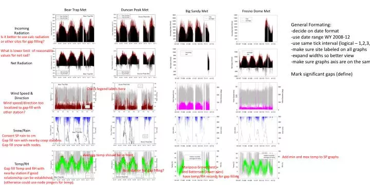
Bear Trap Met Duncan Peak Met Big Sandy Met Fresno Dome Met General Formating: -decide on date format -use date range WY 2008-12 -use same tick interval (logical – 1,2,3,6 mo) -make sure site labeled on all graphs -expand widths so better view -make sure graphs axis are on the same sides (ie wind speed on left) Mark significant gaps (define) Incoming Radiation Is it better to use calc radiation or other sites for gap filling? What is lower limit of reasonable values for net rad? Net Radiation Check legend labels here Wind Speed & Direction Wind speed/direction too localized to gap fill with other station? Snow/Rain Convert SP rain to cm Gap fill rain with nearby coop stations. Gap fill snow with nodes. Average temp should be in front Add min and max temp to SP graphs Temp/RH Mariposa Grove (best) and Batterson (lower elev) have temp/RH records for gap filling Gap fill Temp and RH with nearby station if good relationship can be established (otherwise could use node pingers for temp). Best station for gap filling?