Download
1 / 2
20 likes | 89 Views
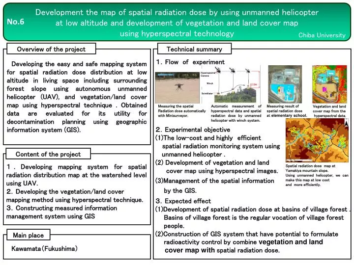
Development the map of spatial radiation dose by using unmanned helicopter at low altitude and development of vegetation and land cover map using hyperspectral technology. No.6. Chiba University. Overview of the project. Technical summary.

E N D
Development the map of spatial radiation dose by using unmanned helicopter at low altitude and development of vegetation and land cover map using hyperspectral technology No.6 Chiba University Overview of the project Technical summary 山木屋地区における山地斜面の空間線量率分布。この測定を無人ヘリで行うことにより、低コスト、簡便に空間線量率マップを作成。 1.Flow of experiment Developing the easy and safe mapping system for spatial radiation dose distribution at low altitude in living space including surrounding forest slope using autonomous unmanned helicopter (UAV), and vegetation/land cover map using hyperspectral technique . Obtained data are evaluated for its utility for decontamination planning using geographic information system (GIS). Hyperspectral Camera Winch Scintillator Measuring the spatial Radiation dose automatically with Minisurveyor. Automatic measurement of hyperspectral data and spatial radiation dose by unmanned helicopter with winch system. Measuring result of spatial radiation dose at elementary school. Vegetation and land cover map from the hyperspectral data. 2.Experimental objective (1)The low-cost and highlyefficient spatial radiation monitoring system using unmanned helicopter . (2) Development of vegetation and land cover map using hyperspectral images. (3)Management of the spatial information by the GIS. Content of the project 1.Developing mapping system for spatial radiation distribution map at the watershed level using UAV. 2.Developing the vegetation/land cover mapping method using hyperspectral technique. 3.Constructing measured information management system using GIS Spatial radiation dose map at Yamakiya mountain slope. Using unmanned helicopter, we can make this map at low cost and more efficiently. 3.Expected effect (1)Development of spatial radiation dose at basins of village forest . Basins of village forest is the regular vocation of village forest people. (2)Construction of GIS system that have potential to formulate radioactivity control by combine vegetation and land cover map with spatial radiation dose. Main place Kawamata(Fukushima)
Results 1.Low-cost, high efficiency radiation monitoring by electric multicopter (Minisurveyor) Below is the results of air dose rate in August and November at Yamakiya Elementary Schoool. Minisurveyor can measure the spatial dose over surplus soil, that is unmeasurable by walking survey. The demonstration experiment of the autonomous (programmed) flying show that Minisurveyor can achieve high efficiency automatic radiation monitoring (see the right figure below) November,2013 August,2013 Altitude:10m Velocity: 2m/sec Results of spatial dose measurement by aoutonomous (programmed) flying Spatial radiation dose rate map at Yamakiya ElementarySchool 2.High-performance, accurate monitoring by YAMAHA/RMAXunmanned engine helicopter The experiment demonstrated that unmanned helicopter can conduct the proximitiy measurement above the tree crown of a forest (immeasurable by walking survey), and estimate the effect of the circumference geogra- phical feature given to a space dose by acquring the data according to altitude in several different topogra- phic features. Spatial dose rate at the north side of the elementary school Measuring result at each alititude over the schoolyard Measuring result at each alititude over the paddy field Spatial dose rate over the forest 3.Development of vegetation and land cover map using hyperspectral images Figures shows different visible-near infrared Spectra in each land coverage and roof materials. Each roof mateirials have different spectral characteristics (left figure) and image classiication can be achieved based on these spectral features. It is necessary to acquire the ground survey (grand truth data) to specify the kind of each classification item. Hyperspectral characteristics of each land cover (left), false color image (middle), image classificatoin result (right). ・We developed the low-cost and highly efficient spatial radiation monitoring system using unmanned helicopter (Minisurveyor, YAMAHA/RMAX) covering the area including not only the field in the low ground region and the place of residence but also forests and waste land where the walking survey is impossible. ・We also developed the hyperspectral (super-multi wavelength) aerial photographing system that can obtain continuous spectrum between the visible and near infrared region anddemonstrated the land cover classification using hyperspectral image. ・We verified ideal wayof managing geographic information system (GIS) for combining the obtained spatial information with various attributes about land.