Download
1 / 1

E N D
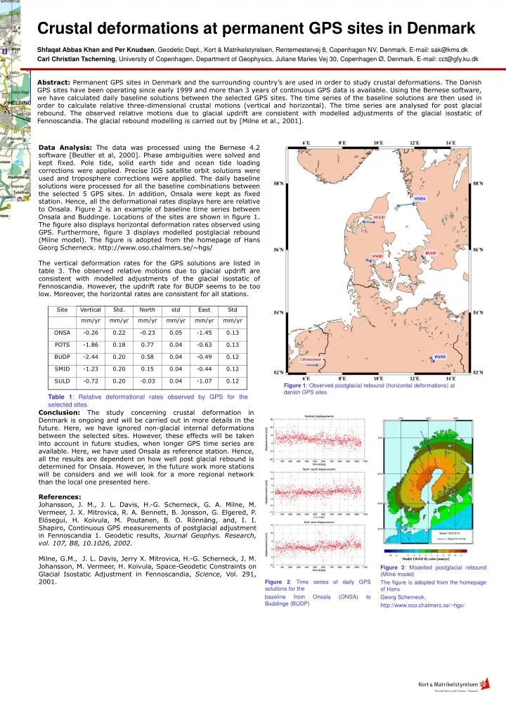
Abstract: Permanent GPS sites in Denmark and the surrounding country’s are used in order to study crustal deformations. The Danish GPS sites have been operating since early 1999 and more than 3 years of continuous GPS data is available. Using the Bernese software, we have calculated daily baseline solutions between the selected GPS sites. The time series of the baseline solutions are then used in order to calculate relative three-dimensional crustal motions (vertical and horizontal). The time series are analysed for post glacial rebound. The observed relative motions due to glacial updrift are consistent with modelled adjustments of the glacial isostatic of Fennoscandia. The glacial rebound modelling is carried out by [Milne et al., 2001]. Crustal deformations at permanent GPS sites in Denmark Data Analysis:The data was processed using the Bernese 4.2 software [Beutler et al, 2000]. Phase ambiguities were solved and kept fixed. Pole tide, solid earth tide and ocean tide loading corrections were applied. Precise IGS satellite orbit solutions were used and troposphere corrections were applied. The daily baseline solutions were processed for all the baseline combinations between the selected 5 GPS sites. In addition, Onsala were kept as fixed station. Hence, all the deformational rates displays here are relative to Onsala. Figure 2 is an example of baseline time series between Onsala and Buddinge. Locations of the sites are shown in figure 1. The figure also displays horizontal deformation rates observed using GPS. Furthermore, figure 3 displays modelled postglacial rebound (Milne model).The figure is adopted from the homepage of Hans Georg Scherneck. http://www.oso.chalmers.se/~hgs/ The vertical deformation rates for the GPS solutions are listed in table 3. The observed relative motions due to glacial updrift are consistent with modelled adjustments of the glacial isostatic of Fennoscandia. However, the updrift rate for BUDP seems to be too low. Moreover, the horizontal rates are consistent for all stations. Shfaqat Abbas Khan and Per Knudsen, Geodetic Dept., Kort & Matrikelstyrelsen, Rentemestervej 8, Copenhagen NV, Denmark. E-mail: sak@kms.dk Carl Christian Tscherning, University of Copenhagen, Department of Geophysics, Juliane Maries Vej 30, Copenhagen Ø,Denmark. E-mail: cct@gfy.ku.dk Figure 1: Observed postglacial rebound (horizontal deformations) at danish GPS sites Table 1: Relative deformational rates observed by GPS for the selected sites. Conclusion: The study concerning crustal deformation in Denmark is ongoing and will be carried out in more details in the future. Here, we have ignored non-glacial internal deformations between the selected sites. However, these effects will be taken into account in future studies, when longer GPS time series are available. Here, we have used Onsala as reference station. Hence, all the results are dependent on how well post glacial rebound is determined for Onsala. However, in the future work more stations will be considers and we will look for a more regional network than the local one presented here. References: Johansson, J. M., J. L. Davis, H.-G. Scherneck, G. A. Milne, M. Vermeer, J. X. Mitrovica, R. A. Bennett, B. Jonsson, G. Elgered, P. Elósegui, H. Koivula, M. Poutanen, B. O. Rönnäng, and, I. I. Shapiro, Continuous GPS measurements of postglacial adjustment in Fennoscandia 1. Geodetic results, Journal Geophys. Research, vol. 107, B8, 10.1026, 2002. Milne, G.M., J. L. Davis, Jerry X. Mitrovica, H.-G. Scherneck, J. M. Johansson, M. Vermeer, H. Koivula, Space-Geodetic Constraints on Glacial Isostatic Adjustment in Fennoscandia, Science, Vol. 291, 2001. Figure 3: Modelled postglacial rebound (Milne model) The figure is adopted from the homepage of Hans Georg Scherneck. http://www.oso.chalmers.se/~hgs/ Figure 2: Time series of daily GPS solutions for the baseline from Onsala (ONSA) to Buddinge (BUDP)