Download
1 / 13
130 likes | 250 Views
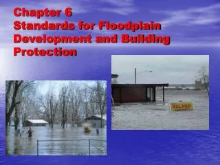
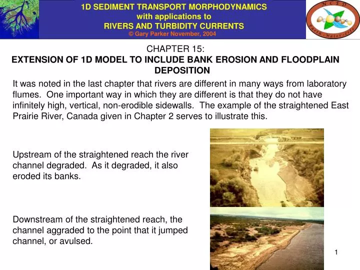
CHAPTER 15: EXTENSION OF 1D MODEL TO INCLUDE BANK EROSION AND FLOODPLAIN DEPOSITION.

E N D
CHAPTER 15: EXTENSION OF 1D MODEL TO INCLUDE BANK EROSION AND FLOODPLAIN DEPOSITION It was noted in the last chapter that rivers are different in many ways from laboratory flumes. One important way in which they are different is that they do not have infinitely high, vertical, non-erodible sidewalls. The example of the straightened East Prairie River, Canada given in Chapter 2 serves to illustrate this. Upstream of the straightened reach the river channel degraded. As it degraded, it also eroded its banks. Downstream of the straightened reach, the channel aggraded to the point that it jumped channel, or avulsed.
DEGRADATION AND BANK EROSION The Little Wekiva River drains a now heavily-urbanized area in the northern suburbs of Orlando, Florida, USA. The stream was straightened, and the floodplain filled in in the period 1940 – 1970. Urbanization of the basin a) reduced infiltration, increasing the severity of floods, and b) cut off most of the supply of sediment to the stream. As a result, the stream degraded severely and produced substantial bank (sidewall) erosion.
COUNTERMEASURES FOR THE LITTLE WEKIVA RIVER NORTH OF ORLANDO, FLORIDA Countermeasures for the problem included both bank protection and grade control (drop) structures. A morphodynamic model of the river considering both bed and bank erosion helped in the design of these countermeasures.
1D EXNER EQUATION OF SEDIMENT CONTINUITY INCLUDING SIDEWALL EROSION If channel degradation is sufficiently severe, the former floodplain surface eventually becomes a terrace, rarely or never flooded by the river. As the river cuts down, it takes out sidewall material on both sides. In a simple 1D model, this rate is equal on both sides. Some parameters are defined below. Bb = channel bottom width, here assumed constant • = bed elevation t = elevation of top of bank (former floodplain) Qt = volume bed material transport rate Ss = sidewall slope (~ constant) p = porosity of the bed and bank deposits Bs = width of sidewall zone on one side Is = volume rate of input per unit length of sediment from sidewalls
1D EXNER EQUATION OF SEDIMENT CONTINUITY INCLUDING SIDEWALL EROSION contd. The width Bs of the sidewall zone on one side is given geometrically from the relation As the bed degrades a distance , the volume of bed sediment removed per unit stream length is (1-p)Bb and the amount of sidewall sediment removed from one side is (1-p)Bs = (1-p)(t-)/Ss The volume rate of supply of material from both sidewalls per unit stream length is thus given as (e.g. Cui et al., in press). Note that Is > 0 for /t < 0 (degradation)
1D EXNER EQUATION OF SEDIMENT CONTINUITY INCLUDING SIDEWALL EROSION contd. The bank material may contain sediment that moves as bed material load and wash load. Let fbb denote the volume fraction of bank material that is coarse enough to move as bed material load. Sediment balance for the control volume takes the form /t(mass of bed sediment) = input rate from upstream – output rate to downstream + input rate from sidewalls This term is positive for a degrading channel or reducing,
1D EXNER EQUATION OF SEDIMENT CONTINUITY INCLUDING SIDEWALL EROSION contd. The Exner equation for sediment conservation for a degrading channel with sidewall erosion thus reduces to the form or recalling that Qt = Bbqt and Bb is assumed to be constant, extra term Thus sidewall erosion suppresses but does not stop channel degradation.
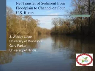
AGGRADATION AND CHANNEL SHIFT The Kosi River flows southward from the Himalaya Mountains to the Ganges River, visible at the bottom of the image. As the Kosi River comes out of the Himalayas, bed slope is greatly reduced, causing sediment to deposit. The channel aggrades, then shifts repeatedly to build up the entire surface of the fan. In the long term, then, the depositional width is the width of the fan, not the width of the river bed. Gradual channel shift is referred to as migration; sudden shift is referred to as avulsion. Kosi River and Fan, India. Satellite image from the web.
CHANNEL SHIFTING ON THE KOSI FAN The map shows channels of the Kosi River from 1731 to 1963. The channel shifts are associated with floods. The fan is densely inhabited, so that migration and avulsion create considerable human hardship. At present the river has been “jacketed” in place with dikes on the western edge of the fan. This is unlikely to be a permanent solution; the river will eventually overwhelm its dikes and begin avulsing again. Channel shift on the Kosi Fan. Adapted from Gole and Chitale (1966).
CAN AVULSION OF A CHANNEL SUBJECTED TO LONG-TERM AGGRADATION BE PREVENTED? The Kusatsu River flows from a mountainous region onto the densely populated plains surrounding Lake Biwa, Japan. The river has not been allowed to avulse for hundreds of years. As a result, the river bed is so high that a tunnel has been excavated underneath it to allow traffic to pass under the river. View from levee looking toward river. View looking behind from same point on levee.
AGGRADATION WITH CHANNEL SHIFT WITHIN A WELL-DEFINED FLOODPLAIN Scroll bars denote channel migration Abandoned channel denotes avulsion The Missouri River has a well-defined floodplain within high valley walls. Since the construction of Garrison Dam in 1956 and the subsequent formation of Lake Sakakawea behind it, base level has been raised on the river. The river bed must aggrade as the delta progrades into Lake Sakakawea. Aggradation gradually fills the entire width of the floodplain through gradual channel migration and sudden channel avulsion. Floodplain width Missouri River at the upstream end of Lake Sakakawea, North Dakota, USA. Image from NASA; https://zulu.ssc.nasa.gov/mrsid/mrsid.pl
EXNER EQUATION FOR AGGRADATION WITH CHANNEL SHIFT Assume that bed material load is transported within a channel of constant width B, but is deposited across the width of the floodplain Bf. The channel sinuosity is defined to be the ratio between average down-channel distance x and average down-valley distance xv between the same points; for meandering rivers is often between 1.5 and 3. In the average over many bends, Thus the reach-averaged, long-term form of the Exner equation becomes (e.g. Parker et al., 1998; Cui et al. 1998). The relation applies for /t > 0. Floodplain deposition suppresses but does not stop channel aggradation.
REFERENCES FOR CHAPTER 15 Cui, Y. and Parker, G, 1998, The arrested gravel front: stable gravel-sand transitions in rivers. Part 2: General numerical solution, Journal of Hydraulic Research, 36(2), 159-182. Cui, Y., Parker, G., Braudrick, C., Dietrich, W. E., and Cluer, B, in press, Dam Removal Express Assessment Models (DREAM). Part 1: Model development and validation, Journal of Hydraulic Research. Gole, C. V. and Chitale, S. V., 1966, Inland delta building activity of the Kosi River, Journal of Hydraulic Engineering, ASCE, 92(2), 111-126. Parker, G. and Cui, Y., 1998, The arrested gravel front: stable gravel-sand transitions in rivers. Part 1: Simplified analytical solution, Journal of Hydraulic Research, 36(1), 75-100.