Download

1 / 29
310 likes | 487 Views
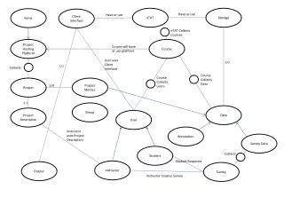
MOHID Course. Lesson 2 How To Create a MOHID Project 19 Março 2013. Content. MOHID Standards Data files, keywords, How to build a timeserie How to build a simulation? Bathymetry Boundary conditions Tide River Inputs Meteorology Initial Conditions Hydrodynamics Properties.

E N D
MOHID Course Lesson 2 How To Create a MOHID Project 19 Março 2013
Content • MOHID Standards • Data files, keywords, How to build a timeserie • How to build a simulation? • Bathymetry • Boundary conditions • Tide • River Inputs • Meteorology • Initial Conditions • Hydrodynamics • Properties
Types of files • ASCII files • Plain text files • Platform independency assured • HDF files • Hierarchical Data Format (http://hdf.ncsa.uiuc.edu/HDF5/) • High volume of data • Platform independent • Others • netcdf files • binary unformatted files t0 t1 t2
ASCII files syntax • Options and values are given by Keywords • Advanced options can be organized in Blocks of information containing a group of keywords • Each line contains only one instruction • Files can have blank lines and keywords don’t have to follow any specific order • All the reading (keywords, keyword values, blocks definition tags) is case sensitive
ASCII files organization - Keywords • Options and values are given by Keywords • A keyword is always defined on the left of a delimiter : • Between the keyword and the delimiter and between the delimiter and the value, blank spaces are allowed • Keep your data files aligned for easy reading
ASCII files organization - Keywords Keywords can define:
Keyword Year Month Day Hour Minute Second START : 2013 03 19 17 0 0 Time and Date format Time and dates in MOHID are set by a keyword with an array of integer numbers Today’s date March 19th, 2008 at 17h00
ASCII files organization - Blocks • Files are organized in Blocks of information • Blocks define advanced options through the combination of groups of keywords • Each block is delimited by a “begin block tag” and an “end block tag” using “<“ and “>” <beginproperty> …. <endproperty> • A block can also be defined inside another block
Space and Time Variation of spatial input Data • Constant • Same value in Space and Time • TimeSerie • Changes with time but all cells have the same value • HDF • Changes in time and Space t0 t1 t2 t0 t1 t2 t0 t1 t2
Construct a timeserie (e.g. Discharge) SERIE_INITIAL_DATA : 2013 3 18 0 0 0 TIME_UNITS : DAYS Days Flow(m3/s) <BeginTimeSerie> 0 1 1 10 2 100 3 10 4 1 <EndTimeSerie>
Under the Hood MOHID Studio Explorer Input Files Output Files
Q t Under the Hood • Input files do not have/solve equations • Input files have equations parameters • Input files have options to run • Input files have the forcing that change with time • Input files have the conditions at the sart Reads Input mu -prey mortality Run Adection/Diffusion and what methods (upwind, central differences) River discharge, Tide, Meteorology Initial Conditions Writes Output Input Files Mohid.exe
Hydrographic zero Bathymetry • Is the 2D depth and bottom boundary • It defines the horizontal grid
Geometry Data File • <begindomain> • ID : 1 • TYPE : SIGMA • LAYERS : 1 • LAYERTHICKNESS : 1.0 • TOLERANCEDEPTH : 0.0500 • DOMAINDEPTH : -99.00 • MININITIALLAYERTHICKNESS : 0.05 • <enddomain> Horizontal Grid Bathymetry Vertical Geometry
Atmosphere Data File Boundary Conditions CONSTANT TIMESERIE • <beginproperty> • NAME : air temperature • UNITS : ºC • DESCRIPTION : Temperature • FILE_IN_TIME : NONE • DEFAULTVALUE : 20. • REMAIN_CONSTANT : 1 • TIME_SERIE : 0 • OUTPUT_HDF : 1 • <endproperty> t0 • <beginproperty> • NAME : air temperature • UNITS : ºC • DESCRIPTION : Temperature • FILE_IN_TIME : TIMESERIE • FILENAME : ..\General Data\Atmosphere\AtmosphereData.dat • DATA_COLUMN : 5 • DEFAULTVALUE : 20. • REMAIN_CONSTANT : 0 • TIME_SERIE : 0 • OUTPUT_HDF : 1 • <endproperty> t1 t2 20 t0 t1 t2
Discharges Data File Boundary Conditions CONSTANT TIMESERIE • <begindischarge> • NAME : Tagus • DESCRIPTION : Enter a short description • I_CELL : 107 • J_CELL : 149 • K_CELL : 1 • DEFAULT_FLOW_VALUE : 20.0 • <enddischarge> • <begindischarge> • NAME : Tagus • DESCRIPTION : Enter a short description • I_CELL : 107 • J_CELL : 149 • K_CELL : 1 • DEFAULT_FLOW_VALUE : 20.0 • DATA_BASE_FILE : ..\General Data\Boundary Conditions\DichargeExample.srd • FLOW_COLUMN : 2 • <enddischarge>
Hydrodynamics Data File • CORIOLIS : 1 • TIDE : 1 • WATER_DISCHARGES : 1 • WIND : 1 • Other options compute advection diffusion, explicit, implicit. If not defined will have default values • !INITIAL_ELEVATION : 0 • !INITIAL_ELEVATION_VALUE : 0 Initial Conditions
Model Data File • START : 2013 3 18 12 0 0 • END : 2013 3 19 0 0 0 • VARIABLEDT : 1 • DT : 15. • MAXDT : 60.
Water Properties File • <beginproperty> • NAME : temperature • UNITS : ºC • DESCRIPTION : No description was given. • INITIALIZATION_METHOD : CONSTANT • DEFAULTVALUE : 20 • ADVECTION_DIFFUSION : 1 • SURFACE_FLUXES : 1 • DISCHARGES : 1 • OUTPUT_HDF : 1 • TIME_SERIE : 1 • <endproperty> Initial Conditions t0 20
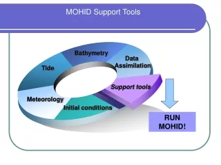
How to Build a MOHID Run • Bathymetry (Ex. 1) • Boundary Conditions (Ex. 2) • Meteorology • Discharge • Tide (automatic since it can be predicted astronomically) • Initial Conditions (Ex. 3)
Ex.1 Create Bathymetry • Bathymetry • Map -> Ascii -> XYZ points - Open the bathymetric data in Digital Terrain\BathymetryData • Create the model Horizontal Grid in Tools -> Grids-> Constant • Pick a origin – select origin close to data origin • Click Auto-Update • Leave number of cells 100x100 • Define the dx (x spacing) as 0.008º (~800m) • Define the dy (y spacing) as 0.006º (~600m) • Save the grid in Digital Terrain\Grids\ and give name (e.g. TagusGrid) • Map -> Ascii -> Polygon - Open the polygon Coast line in Digital Terrain\CoastLine. This is the land and no compute points! • Create the Bathymetry – Tools -> Grid Data Tools -> From Points • Verify the grid selected is the one created • Select Coast line as non compute points • Verify if Point data is selected • Interpolate: Average • Save the bathymetry in Digital Terrain and pick a name (e.g. Tagus_Average) • Click Process • Do the same as previous but now with Interpolate: Triangulation and save with different name (e.g. Tagus_Triang) • See where bathymetry is refered to the model
Ex 2. Define Boundary Conditions • Constant • In the reference simulation (Run 1) check where constant discharge and meteorology properties are defined • Dicharge - DEFAULT_FLOW_VALUE and no file used • Meteorology - FILE_IN_TIME : NONE DEFAULTVALUE : X. REMAIN_CONSTANT : 1
Ex 2. Define Boundary Conditions • Time Serie • Select the project, create a new run (Project -> New Simulation) and name it (e.g. Tide_TagusTimeSerie_MeteoTimeSerie) • Copy the data files from the run 1 (Project -> Copy Simulation) • Edit the discharge and uncomment the DATA_BASE_FILE and FLOW_COLUMN. Check the file that will be used and open it. • Create a meteorology timeseries in Boundary Conditions\Meteorology and edit the Meteorology file to read it • Run the simulation. The model will use now timeseries for flow and for meteotology as real data
Ex 3. Initial Conditions • In the reference simulation (Run 1) check the initial conditions: • Hydrodynamics • INITIALIZATION_ELEVATION : 1 • Define Level with INITIALIZATION_ELEVATION_VALUE • INITIALIZATION_ELEVATION : 0 • Defined by the OpenBoundary - Tide • Water Properties • INITIALIZATION_METHOD : CONSTANT • DEFAULTVALUE : X.
Ex 3. Initial Conditions • Create a new simulation similar as Run1 and create a continuation that will continue after it – Select Run and Project -> New Run and name it • Check that CONTINUOUS : 1 is present in Hydrodynamics • Add OLD : 1 in every property of Water Properties and change it to 1 in Langragian Origin • Change End Date. Verify that Start Date is same and end Date of the previous. • This run will have the initial conditions as the last instant of the previous.
Recall • MOHID formats and keywords • Space Inputs may be constant, time-variant (Timeseries) and time and space variant (HDF) • Discharges may be defined by constant or timeserie • Created Bathymetry from point data • Checked Boundary conditions and changed forcing to timeserie (more realistic) in discharge and meteorology • Checked Initial conditions and created continuous simulation reading initial conditions from previous
Next Lesson • Continue Unfinished examples • Free time to testing and doubts
Links Página principal do sistema MOHID http://www.mohid.com/ MOHID Wikipédia: http://wiki.mohid.com/wiki Fórum de discussão MOHID http://www.mohid.com/forum/