Download
1 / 2
20 likes | 190 Views
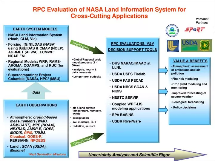
Data. RPC Evaluation of NASA Land Information System for Cross-Cutting Applications. Potential Partners. EARTH SYSTEM MODELS. NASA Land Information System (Noah, CLM, Vic) Forcing: [G|N]LDAS (NASA) using [G|E]DAS & CMAP (NCEP), AGRMET (AFWA), ECMWF; NCAR FNL

E N D
Data RPC Evaluation of NASA Land Information System for Cross-Cutting Applications Potential Partners EARTH SYSTEM MODELS • NASA Land Information System (Noah, CLM, Vic) • Forcing: [G|N]LDAS (NASA) using [G|E]DAS & CMAP (NCEP), AGRMET (AFWA), ECMWF; NCAR FNL • Regional Models: WRF; RAMS-AROMA, COAMPS, and RUC (for evaluations) • Supercomputing: Project Columbia (NASA), HPC2 (MSU) RPC EVALUATIONS, V&V DECISION SUPPORT TOOLS Predictions • DHS NARAC/IMAAC at LLNL • USDA USFS Firelab • USDA FAS PECAD • USDA NRCS SCAN & NIDIS • NSSTC SERVIR • Coupled WRF-LIS modeling applications • EPA BASINS • USBR RiverWare • Global/Regional scale model products (1 – 50km) • analysis, hourly & daily forecasts • Longer-term outlooks VALUE & BENEFITS • Atmospheric assessment of emissions and air pollution • Fire risk modeling • Crop yield modeling and monitoring • Improved forecasting of severe weather • Ecological forecasting • Policy decisions EARTH OBSERVATIONS • air & land surface temperature, humidity, winds • precipitation • soil moisture, SST • radiation, aerosol • Atmosphere: ground-based measurements (WMO, ARM/CART), MPE (NOAA), NEXRAD, AMSR-E, GOES, MODIS, GPM, TRMM, Cloudsat, GOES-R, PERSIANN, NPOESS • Land :SCAN (USDA), Mesonet Observations Uncertainty Analysis and Scientific Rigor *Next Generation Missions
Data RPC Evaluation of NASA Land Information System for Application in USDA-NRCS SCAN DST Partners EARTH SYSTEM MODELS • NASA Land Information System (Noah, Catchment LSM) • Forcing: [G|N]LDAS (NASA) using [G|E]DAS & CMAP (NCEP), AGRMET (AFWA), ECMWF, NCAR FNL, NARR, RUC • Data Assimilation: EKF, EnKF • Supercomputing: Project Columbia (NASA), HPC2 (MSU) RPC EVALUATIONS, V&V USDA-NRCS SCAN DST Predictions • Soil moisture maps from 12x12 km2 to 1x1 km2 • Sensitivity analyses using OSEs • AMSR-E data assimilation • OSSEs to help optimize DST network • NOAA NIDIS • Coupled WRF-LIS modeling applications • Global/Regional scale model products (1 – 50km) • soil moisture maps • Longer-term outlooks VALUE & BENEFITS • Mitigate drought effects • Support flood analysis • Producer decision making – planting, production, disease, pest management • Crop yield modeling and monitoring • Improved forecasting of severe weather and climate outlook • Ecological forecasting • Policy decisions EARTH OBSERVATIONS • air & land surface temperature, humidity, winds • precipitation • soil moisture, SST • radiation, aerosol • Atmosphere: ground-based measurements (WMO, ARM/CART), MPE (NOAA), NEXRAD, AMSR-E, GOES, MODIS, GPM, TRMM, GOES-R, PERSIANN, NPP, NPOESS • Land :SCAN (USDA), Mesonet, Producer-Cooperator Observations Uncertainty Analysis and Scientific Rigor *Next Generation Missions