Download

1 / 14
140 likes | 306 Views
APROVECHAMIENTO DE ACUIFEROS. HIDROGEOLOGÍA. HIDROGEOLOGÍA-AGUAS SUBTERRÁNEAS

E N D
APROVECHAMIENTO DE ACUIFEROS
HIDROGEOLOGÍA HIDROGEOLOGÍA-AGUAS SUBTERRÁNEAS Estudia el almacenamiento, circulación y distribución de las aguas terrestres en las formaciones geológicas. Manifiesta particularidades como: propiedades físicas, químicas, interacciones con el medio físico biológico y reacciones a la acción del hombre
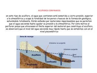
ACUÍFEROS ZONAS DE ACUÍFEROS Alimentación o Recarga: sectores donde el agua (precipitación, riego, cauces superficiales) se infiltra Circulación: comprendida entre la zona de alimentación y la zona de descarga, por donde el agua se desplaza Descarga: sectores donde el agua sale del acuífero, a la superficie como manantial, al mar, lagos, lagunas o ríos
ACUÍFEROS PROPIEDADES DE UN ACUÍFERO Almacenamiento: a través de la Porosidad, describe la capacidad de las rocas para alojar agua. Transmisión: mediante la Permeabilidad, es una cualidad que requiere que la roca porosa pueda transmitir o vincular el agua entre los poros.
ACUÍFEROS TIPOS DE ACUÍFEROS
ACUÍFEROS RELACIÓN ENTRE ACUÍFEROS
CUENCAS HIDROGEOLÓGICAS de MENDOZA • Norte (Ríos Mendoza y Tunuyàn Inferior) • Yalguaraz • Uspallata • Centro (Río Tunuyán Superior) • Sur (Ríos Atuel y Diamante) • Malargüe (Ríos Atuel, Salado y Malargüe)
CUENCA HIDROGRÁFICA PERFILES GEOLÓGICO-GEOFÍSICOS
MONITOREO y CONTROL • REDES MONITORAS • NIVEL ESTÁTICO • CALIDAD (CONDUCTIVIDAD)
FACTIBILIDAD y CONSTRUCCION POZOS de AGUA • POZOS de AGUA FICHAS TÉCNICAS • PERFORACIÓN • PERFILAJE • ANÁLISIS QUÍMICOS • ENSAYOS HIDRÁULICOS
MUCHAS GRACIAS AUTORES ING. ENRIQUE MONTERO - emontero@agua.gob.ar GEÓL. OLGA NELI ZÓTTOLA – ozottola@agua.gob.ar