Download
1 / 13
130 likes | 275 Views
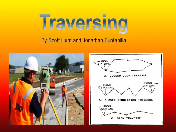
Traversing . By Scott Hunt and Jonathan Funtanilla. Traversing. Definition : A traverse is a series of consecutive lines whose lengths and directions have been measured. Why do we use traverses?

E N D
Traversing By Scott Hunt and Jonathan Funtanilla
Traversing • Definition: • A traverse is a series of consecutive lines whose lengths and directions have been measured. • Why do we use traverses? • The purpose of establishing a traverse is to extend the horizontal control. These surveys usually begin with one given vertical and two horizontal controls. Although you may need more depending on the size of the project.
Closed and Open Traversing • What is a closed traverses? • Closed Traverse: • A closed traverse is one that starts and ends at known points and directions, whether the shape is closed or not. • A closed traverse can be a polygon (closed shape) or link ( closed geometrically but open shape)
Open traversing starts with a known pre-determined point already determined with respect to a horizontal datum, and end at an unknown horizontal position further down the line. Thus open traverses end without closing the loop and are geometrically and mathematically open. • Open traverses are typically used for plotting a strip of land which will be used to plan a route in road construction Open Traverses
Traversing Stations and pins • Traversing stations are chosen in safe and easy to access locations • Lines should be as long as possible to reduce errors. • Bench marks are used to help establish the traverse.
Traversing by Interior Angles • All internal angles and all horizontal distances are measured. • Each angle is measured in direct and reverse mode • A line of known direction should either be given or assumed.
Traversing Calculations
Angular Misclosure • When a closed traverse has been completed the sum of the interior angles for a polygon of points (n) can be determined using the formula • (n-2)x 180 where n =number of sides • Once the misclosure has been calculated it is divided evenly among the readings .
Calculating the area of a closed traverse can be calculated using the formula: • When a closed traverse has been completed the area within can then be calculated. This is done using the methods of calculation. • ABC =1/2 acsin(alfa) when you have three sides a,b,c (referred to as the triangle method) • When the area of the traverse has greater then three sides eg: 6 sides ,you can split the area in half into two triangles and take the sum Traverse Area calculation
Errors in traversing • SYSTEMATIC ERRORS: • A systematic error is an error that always has the same magnitude and sign under the same conditions. These errors are caused by physical and natural conditions that vary depending on the circumstance. Some examples include: • Incorrect prism setting on total station, Curvature and refraction andIncorrect length of a level rod. • RANDOM ERRORS: • A random error is an error that does not follow any fixed relation to the circumstances of the observation. • HUMAN ERRORS: • Human errors are caused by errors the observer makes during surveying process. • INSTRUMENT ERRORS: • Instrument errors are caused by imperfections in the design and construction of the surveying equipment. Some of these errors include: • Calibration of the total station and Laser leveling error. • CALCULATION ERRORS: • Calculation errors occur during the adjustment process of surveying. These errors include:Misclosurecalculation errors (angular and linear)
References • http://www.engr.mun.ca/~sitotaw/Site/Fall2007_files/TP_Manual_CloseTravers-ENGI3703.pdf • http://engineeringtraining.tpub.com/14069/css/14069_463.htm • http://www.firefightermath.org/index.php?option=com_content&view=article&id=58&Itemid=72 • http://www.globalsecurity.org/military/library/policy/army/fm/3-34-331/ch6.htm • http://classof1.com/homework_answers/civil_engineering/traverse_surveying/ • www.globalsecurity.org • http://www.floridageomatics.com/publications/gfl/chapter-three.htm • http://www.oc.nps.edu/oc2902w/geodesy/geolay/gfl84b_a.htm