Download
1 / 1
10 likes | 121 Views
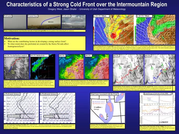
Prefrontal. Frontal Zone. Postfrontal. a) 18 UTC 500mb. b) 18 UTC 700mb. Pictures looking downtown (west) from the University of Utah 15,16 April 2002: Note the gradient of dust delineating the two airmasses. L.

E N D
Prefrontal Frontal Zone Postfrontal a) 18 UTC 500mb b) 18 UTC 700mb Pictures looking downtown (west) from the University of Utah 15,16 April 2002: Note the gradient of dust delineating the two airmasses. L RUC2 Analysis 18 UTC 15 April 2002: (a) 500mb heights(m), absolute vorticity (10^-5 s), and omega(Pa/s). (b) 700mb temperature (ºC), relative humidity (%), and winds (knots) with sfc analysis. Note that the leading edge of 700mb baroclinity is roughly coincident with the surface front. The relative humidity gradient is also roughly coincident with the eastern edge of the 700mb baroclinicity, except downstream of the Sierra Nevada. 18 UTC Reflectivity 18 UTC 20 UTC 18 UTC Vis Sat/Surface analysis 18 UTC 20 UTC L L L Dry Slot WBB 18 UTC Visible Satellite and Radar: Note that the dry slot on the satellite image due partly to downsloping from the Sierra Nevada. Also, the eastern edge of the cloud and precipitation shields are roughly coincident with the leading edge of the 700mb baroclinicity and the position of the surface front. This is evidence that differential sensible heating and evaporative cooling are potential large contributors to frontogenesis. 18 UTC and 20 UTC ADAS Potential Temperature (K), Winds (knots) and Surface Analysis: Note the strength of the 18 UTC potential temperature gradient along the surface front over northern Utah. By 20 UTC, the potential temperature gradient strengthened as the surface low deepened and moved northeastward. Manual Surface Front Analysis over Northern Utah at 18 UTC and 20 UTC: Surface temperature (ºC) and wind (knots). The surface front moved northward as a warm front until 18 UTC, at which point it remained stationary and intensified. Note the strengthening of the temperature gradient and increased confluence across the front. Frontal Passage at University of Utah (WBB) a) Prefrontal Airmass b) Postfrontal Airmass Wind Gusts Associated with the Front $4 million + damage Deep, dry mixed layer ~Moist adiabatic FRONT Maximum Wind Gust Distribution: Note that wind gusts over 25 m/s affected a large area of the Intermountain Region. The strongest winds were mainly prefrontal or immediately behind the front. Pre- and Postfrontal Soundings from Elko, NV:a) 00 UTC/15th , ~1hr before frontal passage. b) 00 UTC/16th . The prefrontal airmass was characterized by a deep, dry, well-mixed layer below 575 mb, whereas the postal frontal airmass closely followed a wet adiabatic profile. Courtesy Univ of Wyoming. Time Series at the University of Utah (WBB): The front was accompanied by a rapid temperature drop (~16ºC in 1 hr), rise in dew point(~11ºC in 5 min), and wind gusts up to 26m/s. Characteristics of a Strong Cold Front over the Intermountain RegionGregory West, Jason Shafer - University of Utah Department of Meteorology • Motivation: • What are the contributing factors in developing a strong surface front? • To what extent does dry prefrontal air created by the Sierra Nevada affect frontogenesis/lysis?