Download
1 / 86
860 likes | 1.05k Views
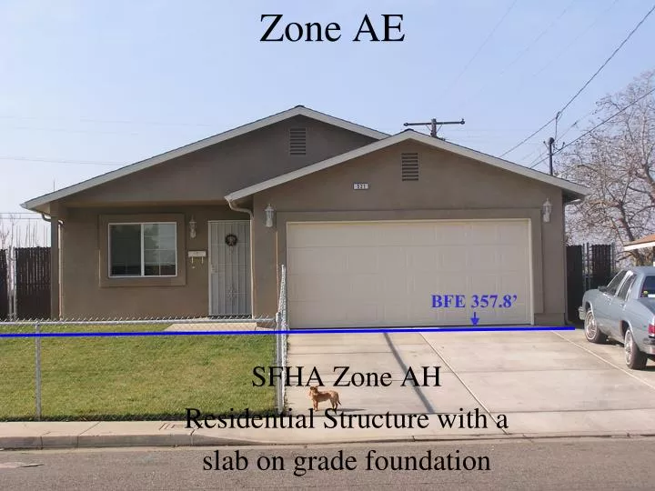
BFE 357.8’. Zone AE. SFHA Zone AH Residential Structure with a slab on grade foundation. John and Gloria Smith. 521 S. Ventura Avenue. Floodville CA 93223. Lot 1 of Tract No. 57, R.M 19-97/APN 130-071-001. Residential. X. 36.2938 N. 119.2120 W. John and Gloria Smith.

E N D
BFE 357.8’ Zone AE SFHA Zone AH Residential Structure with a slab on grade foundation
John and Gloria Smith 521 S. Ventura Avenue Floodville CA 93223 Lot 1 of Tract No. 57, R.M 19-97/APN 130-071-001 Residential X 36.2938 N 119.2120 W
John and Gloria Smith 521 S. Ventura Avenue Floodville CA 93223 Lot 1 of Tract No. 57, R.M 19-97/APN 130-071-001 Residential 36.2938 N 119.2120 W X 1A
1A) Slab on Grade 1B) Raised Slab on Grade or Stem-Wall 2) Basement Foundation 3) Split Level Slab on grade 4) Basement-Split Level Foundation 5) Piers, Post, Pile, Columns, or Shear Wall Foundations With No Obstructions 6) Post, Pile, Piers, Columns, or Shear Wall Foundation With Enclosure 7) Full-Story Foundation Walls 8) Crawl Space Foundation 9) Sub-grade Crawlspace 9 Building Foundation Diagrams
DIAGRAM 1A All slab-on-grade single- and multiple-floor buildings (other than split-level) and high-rise buildings, either detached or row type (e.g., townhouses); with or without attached garage. Distinguishing Feature – The bottom floor is at or above ground level (grade) on at least one side. * C2.b NEXT HIGHER FLOOR C2. a BOTTOM FLOOR GRADE C2. f-g (determined by existing grade)
Diagram 1ASlab-on-grade, 1 story w/attached garage C2.e C2.a C2.d C2.g C2.f
Diagram 1ASlab-on-grade, multiple-floor row type building without attached garage C2.b C2.g C2.a C2.f
Diagram 1BSlab-on-grade, multiple-floor row type building without attached garage C2.b Next higher floor C2.f-g C2.a
DIAGRAM 2 All single- and multiple-floor buildings with basement (other than split-level) and high-rise buildings with basement, either detached or row type (e.g., townhouses); with or without attached garage. Distinguishing Feature – The bottom floor (basement or underground garage) is below ground level (grade) on all sides. Buildings constructed above crawl spaces that are below grade on all sides should also use this diagram.* C2.a NEXT HIGHER FLOOR C2.b GRADE BOTTOM FLOOR (BASEMENT) C2.f-g (determined by existing grade)
Diagram 2Multiple-floor building with basement, without attached garage
C2.a C2.b HIGHER FLOORS NEXT HIGHER FLOOR GRADE BOTTOM FLOOR DIAGRAM 3 All split-level buildings that are slab-on-grade, either detached or row type (e.g., townhouses); with or without attached garage. Distinguishing Feature – The bottom floor (excluding garage) is at or above ground level (grade) on at least one side .* C2.f-g (determined by existing grade)
Diagram 3Slab-on-grade, split-level building without attached garage
C2.a C2.b HIGHER FLOORS GRADE NEXT HIGHER FLOOR Bottom Floor (Basement) BOTTOM FLOOR (BASEMENT) (determined by existing grade) DIAGRAM 4 All split-level buildings (other than slab-on-grade), either detached or row type (e.g., townhouses); with or without attached garage. Distinguishing Feature – The bottom floor (basement or underground garage) is below ground level (grade) on all sides. Buildings constructed above crawl spaces that are below grade on all sides should also use this diagram. * C2.f-g
C2.b NEXT HIGHER FLOOR C2.a ELEVATED FLOOR GRADE (determined by existing grade) C2.f-g (For V zones only) C2.c DIAGRAM 5 All buildings elevated on piers, posts, columns, or parallel shear walls. No obstructions below the elevated floor. Distinguishing Feature – For all zones, the area below the elevated floor is open, with no obstruction to flow of flood waters (open lattice work and/or readily removable insect screening is permissible).
Diagram 5Multi-level building elevated on pilesw/no obstructions below the elevated floor
NEXT HIGHER FLOOR C2.a C2.b ELEVATED FLOOR GRADE ENCLOSURE C2.f-g C2.c DIAGRAM 6 All buildings elevated on piers, posts, columns, or parallel shear walls with full or partial enclosure below the elevated floor. Distinguishing Feature– For all zones, the area below the elevated floor is enclosed, either partially or fully. In A Zones, the partially or fully enclosed area below the elevated floor is with or without openings** present in the walls of the enclosure. Indicate information about enclosure size and openings in Section A – Property Information. A8.a-c Determine enclosure size & openings, if any (determined by existing grade) (For V zones only)
Diagram 6Multi-level building elevated withpartial enclosure
DIAGRAM 7 All buildings elevated on full-story foundation walls with a partially or fully enclosed area below the elevated floor. This includes walkout levels, where at least one side is at or above grade. The principal use of this building is located in the elevated floors of the building. Distinguishing Feature– For all zones, the area below the elevated floor is enclosed, either partially or fully. In A Zones, the partially or fully enclosed area below the elevated floor is with or without openings** present in the walls of the enclosure. Indicate information about enclosure size and openings in Section A – Property Information. C2.b NEXT HIGHER FLOOR C2.a C2.g WALKOUT LEVEL C2.f (Enclosure) GRADE A8.a A8.b-c OPENINGS**
Diagram 7Building elevated on full-story foundation walls with a fully enclosed area below the elevated floor
DIAGRAM NUMBER 8 ALL BUILDINGS ELEVATED ON A CRAWL SPACE WITH THE FLOOR OF THE CRAWL SPACE AT OR ABOVE GRADE ON AT LEAST ONE SIDE, WITH OR WITHOUT AN ATTACHED GARAGE. Distinguishing Feature - For all zones, the area below the first floor is enclosed by solid or partial perimeter walls. In all A zones, the crawl space is with or without openings** present in the walls of the crawl space. Indicate information about crawl space and openings in Section A – Property Information. C2.a C2.b Next Higher Floor C2.g C2.f GRADE CRAWL SPACE A8.b-c A8.a OPENINGS**
Diagram 8One-story building on crawl spacewith attached garage
Diagram 9Sub-grade Crawlspace C2.b C2.g Sub-grade crawl space C2.f A8.a A8 b-c C2.a
Flood Openings ** An “opening” (flood vent) is defined as a permanent opening in a wall that allows for the free passage of water automatically in both directions without human intervention.
Requirements for Flood Openings Under the NFIP, a minimum of two openings is required for enclosures or crawl spaces with a total net area of not less than one square inch for every square foot of area enclosed.
…Requirements Continued Openings must be on at least two differentsides of the enclosed area. If a building has more than one enclosed area, each area must have openings on exterior walls to allow floodwater to directly enter. The bottom of the openings must be no higher than one footabove the grade underneath the flood vents.
Alternative Option Alternatively, you may submit a certification by a registered professional engineer or architect that the design will allow for the automatic equalization of hydrostatic flood forces on exterior walls. A window, a door or a garage door is not an acceptable opening.
John and Gloria Smith 521 S. Ventura Avenue Floodville CA 93223 Lot 1 of Tract No. 57, R.M 19-97/APN 130-071-001 Residential 119.2120 W 36.2938 N X 1A 400 N/A N/A 0 0 N/A X X
BFE 357.8’ Zone AE
SECTION B FLOOD INSURANCE RATE MAP (FIRM) INFORMATION B2. COUNTY NAME B3. STATE B1. NFIP COMMUNITY NAME & COMMUNITY NUMBER Floodville 060001 B6. FIRM INDEX DATE B4. MAP AND PANEL NUMBER B5. SUFFIX B7. FIRM PANEL EFFECTIVE/REVISED DATE B8. FLOOD ZONE(S) B9. BFE(S) (Zone AO, use depth) B10. Indicate the source of the Base Flood Elevation (BFE) data or base flood depth entered in Item B9. |_|FIS Profile |_|FIRM |_|Community Determined |_| Other (Describe): B11. Indicate the elevation datum used for the BFE in Item B9: |_|NGVD 29 |_|NAVD 88 |_| Other (Describe): B12. Is the building located in a Coastal Barrier Resources System (CBRS) area or Otherwise Protected Area (OPA)? |_| Yes |_| NO Designation Date |_| CBRS|_| OPA
COUNTYWIDE FIRM NATIONAL FLOOD INSURANCE PROGRAM FIRM FLOOD INSURANCE RATE MAP RIVER COUNTY, CALIFORNIA AND INCORPORATED AREAS PANEL 10 OF 40 (SEE MAP INDEX FOR PANELS NOT PRINTED) B1. Community Name B1. Community Number CONTAINS COMMUNITYNUMBERPANELSUFFIX FLOODVILLE 060001 0010 C RIVER COUNTY 060002 0010 C UNINCORPORATED AREAS MAP NUMBER 06002C0010 C MAP REVISED: JUNE 16, 2009 Federal Emergency Management Agency
SECTION B FLOOD INSURANCE RATE MAP (FIRM) INFORMATION B2. COUNTY NAME B3. STATE B1. NFIP COMMUNITY NAME & COMMUNITY NUMBER Floodville 060001 River County CA B6. FIRM INDEX DATE B4. MAP AND PANEL NUMBER B5. SUFFIX B7. FIRM PANEL EFFECTIVE/REVISED DATE B8. FLOOD ZONE(S) B9. BFE(S) (Zone AO, use depth) 06002C0010 B10. Indicate the source of the Base Flood Elevation (BFE) data or base flood depth entered in B9. |_|FIS Profile |_|FIRM |_|Community Determined |_| Other (Describe): B11. Indicate the elevation datum used for the BFE in B9: |_|NGVD 29 |_|NAVD 88 |_| Other (Describe): B12. Is the building located in a Coastal Barrier Resources System (CBRS) area or Otherwise Protected Area (OPA)? |_| Yes |_| NO
COUNTYWIDE FIRM NATIONAL FLOOD INSURANCE PROGRAM FIRM FLOOD INSURANCE RATE MAP RIVER COUNTY, CALIFORNIA AND INCORPORATED AREAS PANEL 10 OF 40 (SEE MAP INDEX FOR PANELS NOT PRINTED) CONTAINS COMMUNITYNUMBERPANELSUFFIX FLOODVILLE 060001 0010 C RIVER COUNTY 060002 0010 C UNINCORPORATED AREAS B4. Map Number MAP NUMBER 06002C0010 C MAP REVISED: JUNE 16, 2009 Federal Emergency Management Agency
SECTION B FLOOD INSURANCE RATE MAP (FIRM) INFORMATION B2. COUNTY NAME B3. STATE B1. NFIP COMMUNITY NAME & COMMUNITY NUMBER Floodville 060001 River County CA B6. FIRM INDEX DATE B4. MAP AND PANEL NUMBER B5. SUFFIX B7. FIRM PANEL EFFECTIVE/REVISED DATE B8. FLOOD ZONE(S) B9. BFE(S) (Zone AO, use depth) 06002C0010 C B10. Indicate the source of the Base Flood Elevation (BFE) data or base flood depth entered in B9. |_|FIS Profile |_|FIRM |_|Community Determined |_| Other (Describe): B11. Indicate the elevation datum used for the BFE in B9: |_|NGVD 29 |_|NAVD 88 |_| Other (Describe): B12. Is the building located in a Coastal Barrier Resources System (CBRS) area or Otherwise Protected Area (OPA)? |_| Yes |_| NO Designation Date:
COUNTYWIDE FIRM NATIONAL FLOOD INSURANCE PROGRAM FIRM FLOOD INSURANCE RATE MAP RIVER COUNTY, CALIFORNIA AND INCORPORATED AREAS PANEL 10 OF 40 (SEE MAP INDEX FOR PANELS NOT PRINTED) CONTAINS COMMUNITYNUMBERPANELSUFFIX FLOODVILLE 060001 0010 C RIVER COUNTY 060002 0010 C UNINCORPORATED AREAS B5. Suffix MAP NUMBER 06002C0010 C MAP REVISED: JUNE 16, 2009 Federal Emergency Management Agency
SECTION B FLOOD INSURANCE RATE MAP (FIRM) INFORMATION B2. COUNTY NAME B3. STATE B1. NFIP COMMUNITY NAME & COMMUNITY NUMBER Floodville 060001 River County CA B6. FIRM INDEX DATE B4. MAP AND PANEL NUMBER B5. SUFFIX B7. FIRM PANEL EFFECTIVE/REVISED DATE B8. FLOOD ZONE(S) B9. BFE(S) (Zone AO, use depth) June 16, 2009 06002C0010 C B10. Indicate the source of the Base Flood Elevation (BFE) data or base flood depth entered in B9. |_|FIS Profile |_|FIRM |_|Community Determined |_| Other (Describe): B11. Indicate the elevation datum used for the BFE in B9: |_|NGVD 29 |_|NAVD 88 |_| Other (Describe): B12. Is the building located in a Coastal Barrier Resources System (CBRS) area or Otherwise Protected Area (OPA)? |_| Yes |_| NO Designation Date:
COUNTYWIDE FIRM INDEX NATIONAL FLOOD INSURANCE PROGRAM FIRM FLOOD INSURANCE RATE MAP RIVER COUNTY, CALIFORNIA AND INCORPORATED AREAS (SEE TABLE SHOWN ABOVE FOR LISTING OF COMMUNITIES) MAP INDEX PANELS PRINTED: 10, 20, 25, 30, 35, 40 MAP NUMBER 06002CIND0A MAP REVISED: JUNE 16, 2009 Federal Emergency Management Agency B6. FIRM Index Date
SECTION B FLOOD INSURANCE RATE MAP (FIRM) INFORMATION B2. COUNTY NAME B3. STATE B1. NFIP COMMUNITY NAME & COMMUNITY NUMBER Floodville 060001 River County CA B6. FIRM INDEX DATE B4. MAP AND PANEL NUMBER B5. SUFFIX B7. FIRM PANEL EFFECTIVE/REVISED DATE B8. FLOOD ZONE(S) B9. BFE(S) (Zone AO, use depth) June 16, 2009 June 16, 2009 06002C0010 C B10. Indicate the source of the Base Flood Elevation (BFE) data or base flood depth entered in B9. |_|FIS Profile |_|FIRM |_|Community Determined |_| Other (Describe): B11. Indicate the elevation datum used for the BFE in B9: |_|NGVD 29 |_|NAVD 88 |_| Other (Describe): B12. Is the building located in a Coastal Barrier Resources System (CBRS) area or Otherwise Protected Area (OPA)? |_| Yes |_| NO Designation Date:
COUNTYWIDE FIRM NATIONAL FLOOD INSURANCE PROGRAM FIRM FLOOD INSURANCE RATE MAP RIVER COUNTY, CALIFORNIA AND INCORPORATED AREAS PANEL 10 OF 40 (SEE MAP INDEX FOR PANELS NOT PRINTED) CONTAINS COMMUNITYNUMBERPANELSUFFIX FLOODVILLE 060001 0010 C RIVER COUNTY 060002 0010 C UNINCORPORATED AREAS MAP NUMBER 06002C0010 C MAP REVISED: JUNE 16, 2009 Federal Emergency Management Agency B7. Revised Date
SECTION B FLOOD INSURANCE RATE MAP (FIRM) INFORMATION B2. COUNTY NAME B3. STATE B1. NFIP COMMUNITY NAME & COMMUNITY NUMBER Floodville 060001 River County CA B6. FIRM INDEX DATE B4. MAP AND PANEL NUMBER B5. SUFFIX B7. FIRM PANEL EFFECTIVE/REVISED DATE B8. FLOOD ZONE(S) B9. BFE(S) (Zone AO, use depth) June 16, 2009 357.8’ AH June 16, 2009 06002C0010 C B10. Indicate the source of the Base Flood Elevation (BFE) data or base flood depth entered in B9. |_|FIS Profile |_|FIRM |_|Community Determined |_| Other (Describe): X B11. Indicate the elevation datum used for the BFE in B9: |_|NGVD 29 |_|NAVD 88 |_| Other (Describe): B12. Is the building located in a Coastal Barrier Resources System (CBRS) area or Otherwise Protected Area (OPA)? |_| Yes |_| NO Designation Date:
SECTION B FLOOD INSURANCE RATE MAP (FIRM) INFORMATION B2. COUNTY NAME B3. STATE B1. NFIP COMMUNITY NAME & COMMUNITY NUMBER Floodville 060001 River County CA B6. FIRM INDEX DATE B4. MAP AND PANEL NUMBER B5. SUFFIX B7. FIRM PANEL EFFECTIVE/REVISED DATE B8. FLOOD ZONE(S) B9. BFE(S) (Zone AO, use depth) June 16, 2009 357.8’ AH June 16, 2009 06002C0010 C B10. Indicate the source of the Base Flood Elevation (BFE) data or base flood depth entered in B9. |_|FIS Profile |_|FIRM |_|Community Determined |_| Other (Describe): X B11. Indicate the elevation datum used for the BFE in B9: |_|NGVD 29 |_|NAVD 88 X |_| Other (Describe): B12. Is the building located in a Coastal Barrier Resources System (CBRS) area or Otherwise Protected Area (OPA)? |_| Yes |_| NO X N/A Designation Date:
Finished Construction Select “Finished Construction” only when all machinery and/or equipment such as furnaces, hot water heaters, heat pumps, air conditioners, and elevators and their associated equipment have been installed and the grading around the building is completed.