Download

1 / 18
180 likes | 182 Views
Join us for a comprehensive workshop on exploring and mapping marine habitats. Learn about reefs, seafloor mapping techniques, and GIS analysis. Hands-on activities included.

E N D
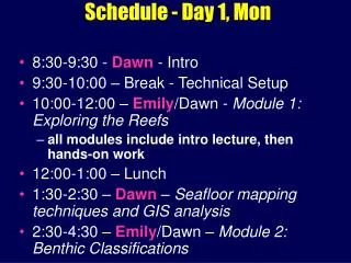
Schedule - Day 1, Mon • 8:30-9:30 - Dawn - Intro • 9:30-10:00 – Break - Technical Setup • 10:00-12:00 – Emily/Dawn - Module 1:Exploring the Reefs • all modules include intro lecture, then hands-on work • 12:00-1:00 – Lunch • 1:30-2:30 – Dawn – Seafloor mapping techniques and GIS analysis • 2:30-4:30 – Emily/Dawn – Module 2:Benthic Classifications
http://dusk.geo.orst.edu/djl/samoahttp://dusk.geo.orst.edu/djl/samoa/ascchttp://dusk.geo.orst.edu/djl/samoahttp://dusk.geo.orst.edu/djl/samoa/ascc
GIS Terrain Analysis Dawn Wright Department of Geosciences Oregon State University Photo by ASCC GIS Workshop, September, 2004
NOAA Biogeography“Benthic Habitat” from Ikonos By OrSt grad student Emily Lundblad
Terrain Analysis:Bathymetric Position Index(from TPI, Jones et al., 2000, Weiss, 2001) Measure of where a point is in the overall land- or “seascape” Compares elevation of cell to mean elevation of neighborhood Hilltop Middle Coarse BPI Bottom Ridge Crest Fine BPI Lava Channel
BPI Zone and Structure Classification Flowchart Emily Lundblad, OrSt M.S. Thesis
From Greene, Bizarro et al., in press, 2004, The benefits and pitfalls of GIS in marine benthic habitat mapping, in Wright, D.J. and Scholz, D.J. (eds.), Place Matters: Geospatial Tools for Marine Science, Conservation, and Management in the Pacific Northwest, Corvallis, OR: Oregon State University Press.
Terrain Analysis:Rugosity • Measure of how rough or bumpy a surface is, how convoluted and complex • Ratio of surface area to planar area Surface area based on elevations of 8 neighbors 3D view of grid on the left Center pts of 9 cells connected To make 8 triangles Portions of 8 triangles overlapping center cell used for surface area Graphics courtesy of Jeff Jenness, Jenness Enterprises, and Pat Iampietro, CSU-MB
http://dusk.geo.orst.edu/djl/samoahttp://dusk.geo.orst.edu/djl/samoa/ascchttp://dusk.geo.orst.edu/djl/samoahttp://dusk.geo.orst.edu/djl/samoa/ascc