Download
1 / 3
30 likes | 132 Views
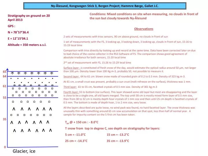
Ny-Ålesund, Kongsvegen Stick 3, Bergen Project; Hammre Børge, Gallet J.C. Conditions: Mixed conditions on site when measuring, no clouds in front of the sun but cloudy towards Ny-Ålesund. Stratigraphy on ground on 20 April 2013 GPS : N = 78˚57’36.4 E = 12˚15’04.1

E N D
Ny-Ålesund, Kongsvegen Stick 3, Bergen Project; Hammre Børge, Gallet J.C. Conditions: Mixed conditions on site when measuring, no clouds in front of the sun but cloudy towards Ny-Ålesund Stratigraphy on ground on 20 April 2013 GPS : N = 78˚57’36.4 E = 12˚15’04.1 Altitude = 350 meters a.s.l. Observations 2 sets of measurements with trios sensors, 90 cm above ground, no clouds in front of sun 1 set of measurements with the FS, 3 looking up, 3 looking down, 3 looking up, clouds in front of sun, 15:16 to 15:19 local time Comparison with trios directly by looking up and record at the same time. Data have been corrected later on due to bad choice of the cosine collector in the RS3 Software of FS. The comparison shows good agreement of absolute irradiance for both sensors, 15:20 local time 2nd set of measurement with FS, 15:26 to 15:29 local time Surface layer : is constituted of fresh snow of the day, would estimate the optical radius around 50 µm, not larger than 100 µm. Density lower than 100 Kg.m-3, probably 50, not possible to measure it. Second layer: 64 to 61 cm: blown snow made of rounded grain of 0.2 to 0.3 mm. Density of 323 kg.m-3. At 61 cm, a small crust was present, probably a sun crust (melt refreeze on the surface), thickness was 1 mm. Third layer: 61 to 55 cm, facetted crystals of 0.5 mm size. Density of 301 kg.m-3 Fourth layer: 55 to bottom (ice surface). This layer showed some old layer but most are disappearing and the layer is close to be a single one, all old layers merged. The top until 38 cm is mostly mixed form layer of 0.5 mm size, then from 38 to 32 cm is mostly depth hoar crystals of 1 mm size and then until 25 cm depth is facetted crystals of 0.5 mm. The bottom is made of depth hoar, 1 to 2 mm size, very loose. All the layers described are quite loose, no wind pack was found, no hard facetted layer. The snow thickness was unusually thin with something around 65 cm sow accumulation on that spot, less than half of normal year. A sample for impurity content on the 5 first cm has been taken. 65 64 61 55 35 Tair@ + 150 cm : - 8.0°C T snow from top in degree C, see depth on stratigraphy for layers: 5 cm = -11.0°C 15 cm = -13.2°C 25 cm = -14.3°C 35 cm = -13.9°C 0 Glacier, ice