Download
1 / 35
360 likes | 548 Views
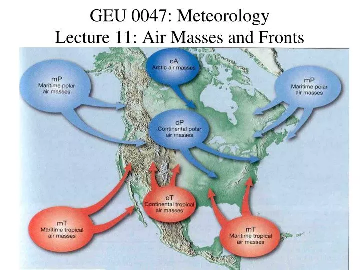
GEU 0047: Meteorology Lecture 11: Air Masses and Fronts. Air Masses. the air with similar properties of temperature and moisture which covers a large area Semi-permanent structures in the atmosphere. Air Mass Classifications. Moisture content Dry Continental (c)

E N D
Air Masses • the air with similar properties of temperature and moisture • which covers a large area • Semi-permanent structures in the atmosphere
Air Mass Classifications • Moisture content • Dry Continental (c) • Moist Marine (m) • Temperature • Cold Polar (P), Arctic (A) • Warm Tropical (T), • Results in 5 basic types • cA Continental Arctic • cP Continental Polar mP Marine Polar • cT Continental Tropical mT Marine Tropical
Arctic Air (cA) • Arctic Air Mass • Bitterly Cold and Usually Very Dry • Develops over the snow or ice covered regions of continents • Similar to polar air masses but usually develops in regions north of 60N where there is little or no insolation during the winter.
Continental Polar (cP) • Continental Polar Air Mass • Cold, Dry • Develops over the interior of • North America -- Central Canada -- Siberia
Marine Polar (mP) • Marine Polar Air Mass • Cold, Moist • Develops over the cold ocean waters of the North Pacific and North Atlantic • Usually associated with conversion of cP siberian air to mP which is moistened and warmed from the Japanese “Gulf Stream Current” • Moves across the N. Pacific to affect N. California and the Pacific NW • Responsible for fueling “Nor-easters”
Tropical (T) • Continental Tropical (cT) • Hot, Dry • Develops over the deserts of Mexico and the Southwestern United States • Very unstable because of heat and convection, but cloudless because of lack of moisture. • Marine Tropical (mT) • Warm, Humid • Develops over the tropical and subtropical oceans and the Gulf of Mexico
Example Air Masses cP mT
Air Mass Modification • Air masses do not always remain over their source regions. • If the air moves over a region that is different from where it originated, the air mass will be modified, or changed, by the land/ocean surface that the air is travelling over. • Changes include: warming, cooling, adding or reducing moisture content
Air Mass Modification cP The cP air mass will be warmed by the warmer land that it passes over. Warmer Land
Changes in Stability Cold air mass moves over a warmer surface. The lower layers are warmed and may become unstable. cP Warm, Moist
Stability Changes Dry Adiabat Moist Adiabat Environment Cold air mass moving over a warmer surface. Altitude (m) Altitude (m) Temperature (C) Temperature (C) Sounding Before Modification: Conditionally Unstable After modification: Absolutely Unstable
Stability Changes Warm air mass moves over a colder surface. The lower layers are cooled and tend to stablize. mT Cold Warm, Moist
Stability Changes Dry Adiabat Moist Adiabat Environment Warm air mass moves over a colder surface. Altitude (m) Altitude (m) Temperature (C) Temperature (C) Sounding Before Modification: Conditionally Unstable After modification: Absolutely stable
Fronts • Front • A narrow transition zone between air masses of differing densities. • The density differences usually arise from temperature differences. • Density differences may be a result of humidity differences (summer). • A front is the boundary or transition zone between different air masses.
Air Mass Invasion • The transition zone is usually narrow (15 to 200 km in width). • Frontal Boundaries may be over 1000 km long. • On maps, we draw the frontal boundary on the warm side of the transition zone.
Idealized Cold Front • Cold Front • A boundary that moves in such a way that the colder (more dense) air advances and displaces the warmer (less dense) air. • The largest temperature differences are normally associated with cold fronts.
Idealized Cold Front Cross-sectional Characteristics Warm Air Cold Air Strong Lifting near the frontal boundary can produce convective clouds.
Idealized Cold Front • Precipitation: • Located on either side of the front. • Convective, showery in nature • If warm air is stable • Nimbostratus, Altostratus • If warm air is unstable • Cumulus, Cumulonimbus, Thunderstorms
Idealized Warm Front • Warm Front • A boundary that moves in such a way that the colder (more dense) air retreats and is replaced by the warmer (less dense) air. • The warm fronts tend to have weaker temperature gradients.
Occluded Front • Cold fronts typically move faster than warm fronts. • Cold fronts can catch up and “overtake” a warm front. • Depending on the different air masses, there are two types of occlusions: • Cold type occlusion • Warm type occlusion
Cold-type Occlusion when the air behind the front is colder than the air ahead of the front. Warm Air Cold Air Cool Air Cold type occlusions are common on the east coast of continents and generally form when the continental polar or arctic air collides with maritime subtropic air.
Warm-type Occlusion When the air behind the front is warmer than the air ahead of the front Warm Air Cold Air Cool Air Warm type occlusions are common on the west coast of continents and generally form when maritime polar air collides with continental polar or arctic air.