Download
1 / 19
190 likes | 304 Views
The inter-comparison of SCIAMACHY and radar cloud top heights Alexander A. Kokhanovsky(1), C. Naud(2), A. Devasthale(3) (1)Institute of Remote Sensing, Bremen University Bremen, Germany (2) NASA GISS, New York, USA (3) Max Planck Institute for Meteorology, Hamburg, Germany

E N D
The inter-comparison of SCIAMACHY and radar cloud top heights Alexander A. Kokhanovsky(1), C. Naud(2), A. Devasthale(3) (1)Institute of Remote Sensing, Bremen University Bremen, Germany (2) NASA GISS, New York, USA (3) Max Planck Institute for Meteorology, Hamburg, Germany alexk@iup.physik.uni-bremen.de
CONTENTS • Rationale • Cloud retrievals using SACURA: the accuracy of the forward model • Inter-comparison study • Conclusions
Rationale: The validation of satellite-derived cloud top heights is needed to establish the accuracy of a given technique for the CTH determination. This can be done either using highly accurate lidar or radar systems in space or on ground.
CLOUD RETRIEVALS USING SACURA: THE ACCURACY OF THE FORWARD MODEL and the physical principles behind retrievals
The cloud optical thickness determination: the physical principle Symbols-SCIATRAN
The cloud top height determination from a satellite The physical principle behind the retrieval
Teh cloud geometrical thickness/bottom height determination from a satellite Preliminary results !
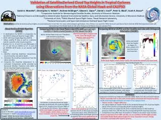
Inter-comparisons ARM SGP site USA 36.6N; 97.5W
Radar: 35-GHz Millimeter wave Cloud Radar 25min 0.5deg ARM (USA): 36.6N; 97.5W
Low clouds scia scia CF CF radar
Low clouds scia scia CF CF radar
The inter-comparisons of CTHs derived using SCIAMACHY, MODIS, and MERIS satellite radar
Table 1. Cloud top heights (in km) of low-level clouds derived from radar and satellite data Table 1. Cloud top heights (in km) of low-level clouds derived from radar and satellite data Table 2. Cloud top heights (in km) of high-level clouds derived from radar and satellite data
Conclusions • The max error of the cloud top height retrievals for low clouds (below 2km) is in the range [-0.5km; 0.5km] • The max error for high clouds(10-12km) is in the range [-3km;+3km].
AcknowledgementsJ. P. BurrowsW. von Hoyningen-HueneV. V. Rozanov, H. Bovensmann, M. Vountas, W. Lotz ESA, DLR