Download
1 / 35
350 likes | 452 Views
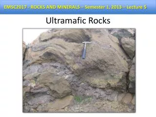
A model for study: Ultramafic ecosystems of Mount Kinabalu. Antony van der Ent and Andrew Fletcher. Introduction. Ultramafic outcrops.

E N D
A model for study: Ultramafic ecosystems of Mount Kinabalu Antony van der Ent and Andrew Fletcher
Ultramafic outcrops • Discrete ultramafic outcrops (‘serpentine ‘) are patchily distributed on every continent with the world’s largest outcrops in Indonesia, the Philippines and Malaysia. • Ultramafic rocks are composed of mafic minerals (high magnesium, iron, nickel, chromium and cobalt) and found in large tectonic masses, which are fragments of the upper mantle obducted in continental margins. • Ultramafics are like ‘geochemical islands’ in a ‘sea of normal soils’.
Ultramafic outcrops • Ultramafic substrates are extreme environments because plants growing in these ecosystems must be able to cope with a number of conditions that are normally adverse to plant growth, such as phytotoxic nickel, very high magnesium and extremely low nutrient concentrations. • Ultramafics are essentially toxic and harsh for plants.
Ultramafic outcrops • Characteristics common among ultramafic ecosystems (Whittaker 1954) : (a) Low stature and biomass production; (b) High levels of endemism; (c) Distinct vegetation composition and structure compared to surrounding non-ultramafic areas. • Plants growing on ultramafics are distinct from the surrounding area
Ultramafic outcrops • As extreme environments, ultramafics make excellent natural laboratories to address topics in evolution, phylogeography, ecology, physiology, including questions of adaptation, biotic response to climate change, etc. • Some ultramafic areas have been well studied through comparative ecological studies involving long-term plot studies (e.g., on Mount Kinabalu, Sabah, Malaysia) accompanied by environmental monitoring sensors that could potentially be networked. • Ultramafics are the ideal ‘model’ ecosystem for a wide range of scientific inquiry.
Ultramafic flora of Sabah • The flora of Sabah is very rich in plant species, with an estimated 8000 higher plants occurring within the boundaries of this state (Wong 1992). • The ultramafic flora of Sabah has a minimum of 2470 plant species, despite covering only 4.6% of the total land area of the State (Proctor et al. 1988). • Plants growing on ultramafics are distinct from the surrounding area
Mount Kinabalu Park • Mount Kinabalu is the most biodiverse place on earth in terms of the number of species-per-area with >5000 species in 200 families and 1000 genera in an area of 1200 km2(Beaman and Beaman, 1990) • Mount Kinabalu contains as much 14% of the total flora of Southeast Asia which has 42.000 species in an area 3.1 million km2 (Roos, 1992) • Mount Kinabalu is the most interesting test case in the world because of its extreme biodiversity and complexity.
Mount Tambuyukon Mount Kinabalu Non-ultramafic Mount Tambuyukon Non-ultramafic
Building a model for Mount Kinabalu • Building a spatial ‘plant distribution model’ for Mount Kinabalu has the potential to help answer some of the most important questions in tropical ecology, such as: • (1) How important are edaphic forces for plant speciation - endemism in the tropical ecosystems? And, ultimately, why are these ecosystems so species-rich? • (2) What factors (temperature, rainfall, soil chemistry, biogeography) govern plant distribution in rainforests? • (3) Is high-endemism vegetation on extreme soils more sensitive or less sensitive to climate change?
Building a model for Mount Kinabalu Spatial plant distribution model
Building a model for Mount Kinabalu • A spatial ‘plant distribution model’ can be derived from spectral and textural analysis of high-resolution imagery, combined with climate, landscape morphological, geological and distribution data. • Multi-species analysis: co-occurrence of species (probability). • Main focus on relationships between climate, soil, and plant distribution. • Potential for wide ranging research on links between distribution, adaptation and evolution.
Data sources & input • Species distribution (70.000+ herbarium vouchers in database) • Satellite imagery (Landsat time-series, IKONOS, acquisition Worldview-2) • Vegetation mapping (existing maps) • Hyperspectral imagery (helicopter-based AISA or UAV) • Spectral and structural attributes of plant species • Elevation models (DSM based on rendering PIX4D + validation) • Geological data (existing maps in ArcGIS) • Geochemistry data (500+ sampling points) • Climate data (15 years of climate monitoring) • Phytochemistry (elemental analysis of 1500+ plants) • Functional data (physiology, gene expression)
What do ground observers see? Aerial-20cm Geoeye-50cm QB2-240cm UAV-2.3cm
Other possible metrics 3D surface point cloud generated to allow effective orthophoto construction (PIX4D)
Elevation measurements Boundary changes, tree growth, tree counts Growth related to aspect, substrate etc
Hyperspectral imagery • Hyperspectral unit (AISA Eaglet) is available in Sabah • 205 spectral bands (400-1000nm) at 25cm resolution on the ground
Broader perspective of Mount Kinabalu case • Mount Kinabalu is the converge point of biogeography in the region and hence scientific questions relating to the evolution and distribution of species has regional relevance. • Large scale lateritic nickel mining threatens ultramafic outcrops in Indonesia and the Philippines. Greater understanding of ultramafic ecosystems might assist in ‘ecosystem restoration’. • Methodologies developed in the Mount Kinabalu case could be used elsewherein the region.
Building a model for Mount Kinabalu Species attributes and field validation Image analysis Spectral + texture: eCognition Spectral data (e.g. 0.25m hyperspectral imagery) Species distribution database 2D imagery PIX4D rendering Geology and geochemistry database Digital Surface Model (DSM) Plant distribution model Climate monitoring data Climate model Species attributes