Download

1 / 15
150 likes | 259 Views
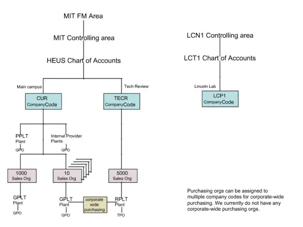
FM Area Diversion International Legislators Forum June 27, 2014. Keith Berndt PE Cass County ND Administrator. Red River Basin. Total Drainage Area: 45,000 square miles. Fargo, ND. Moorhead, MN. Baldhill Dam. Valley City. Maple River Dam. Lisbon. Orwell Dam.

E N D
FM Area DiversionInternational Legislators ForumJune 27, 2014 Keith Berndt PE Cass County ND Administrator
Red River Basin Total Drainage Area: 45,000 square miles Fargo, ND Moorhead, MN Baldhill Dam Valley City Maple River Dam Lisbon Orwell Dam Q 100 year = 34,700 cfs Q 500 year = 61,700 cfs Q max 2009 = 29,500 cfs White Rock Dam North Dakota South Dakota Minnesota
Red River Flooding History • Red River Flood Stage = 18 feet on the Fargo gage at 13th Ave. S. • Exceeded in 50 of the past 111 years • Exceeded 20 of the last 21 years • Catastrophic damages have been prevented by emergency measures • 8 of the 16 “major” floods on record have occurred since 2000 • 2009 was the flood of record • Stage of 40.8 feet • 2-percent chance (50 year) event • Emergency measures cost approximately $70M 2009 Flood Expedited Feasibility Study
Commuting Challenges Interstate 29 Closed April 10. Reopened April 15, 2011. Detour added = 22.8 miles
A willing workforce heeds the call 2009
Volunteers fill the Fargodome Building is 466,000 SF.
FM Area Diversion Project • 1,600 ft wide Diversion Channel in ND with 150,000 acre-feet of Upstream Staging • Outlet near Georgetown, MN • Inlet north of Oxbow, ND • Provides 1-percent (100-year) Risk Reduction • Reduces 1-percent event by >5’ • Extreme Events are Flood- Fightable
FM Diversion Economics 1 in 5 of all North Dakotans will benefit from flood risk reduction $14 Billion = Property Value Receiving Flood Risk Reduction Benefits $4.3 Billion = Wages in the F-M Metro Area $10 Billion = Annual F-M Gross Domestic Product $200 Million = Annual Income & Sales Taxes Generated for North Dakota from F-M Metro $71 Million = Annual Income & Sales Taxes Generated for Minnesota from F-M Metro
Diversion Channel Cross Section (Reach 1) Total Width = 1,600 feet
JUNE 10, 2014 NEWS FLASH! PRESIDENT OMAMA AUTHORIZED FM AREA DIVERSION PROJECT CONSTRUCTION
Overall Funding Approach • $100M • MN • $450M • ND State • $800M* • $1,000M • $450M • ND Local • Federal Cost Share • Non-Federal Cost Share • *WRRDA Authorized $846 Million
Ongoing Efforts Working with upstream interests Additional upstream storage opportunities Cemetery mitigation Oxbow, Hickson, Bakke Levee Construction Fargo Levees Land Acquisition Design
www.fmdiversion.com www.fmdiversion.com