Download
1 / 22
220 likes | 363 Views
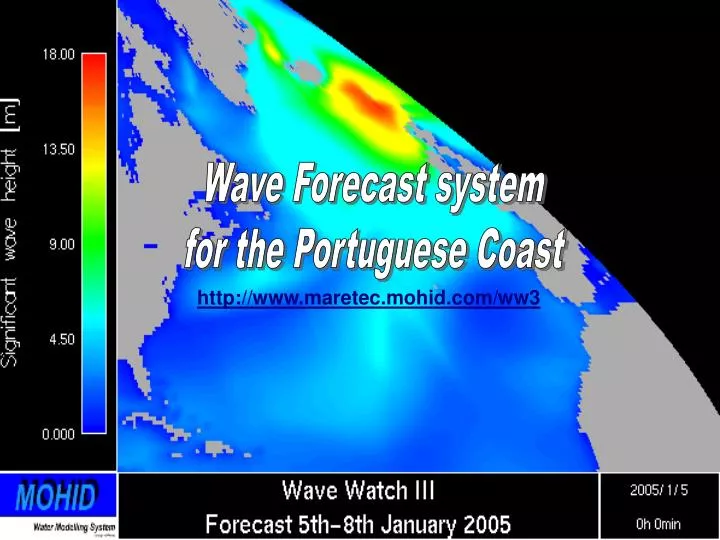
Wave Forecast system for the Portuguese Coast. http://www.maretec.mohid.com/ww3. Who forecasts waves in Portugal?. Project MOCASSIM (IH) Operational wave model for the Portuguese coast (Pinto et al, 2004) WaveWatch III model predictions for the Iberian western coast (Pinto et al, 2003)

E N D
Wave Forecast system for the Portuguese Coast http://www.maretec.mohid.com/ww3
Who forecasts waves in Portugal? • Project MOCASSIM (IH) • Operational wave model for the Portuguese coast (Pinto et al, 2004) • WaveWatch III model predictions for the Iberian western coast (Pinto et al, 2003) • Tests with SWAN coupled with WW3 • Instituto de Meteorologia • 24 hours forecast (no spatial resolution) • Sites de surf • Use coarse resolution U.S. model results • Outras aplicações de modelos de ondas • IST (Naval, Guedes Soares)
Wave Forecast system for the Portuguese Coast – Present state • Wave model – Wave Watch III • Most used model for meso-scale wave modelling • Wind models • GFS (NCAR - resolution = 1ºx1º) • ARPS (MeteoGalicia – resolution = 50x50 km)
Wave Watch III - v2.22 • Wave Watch III (Tolman 1997, 1999a) • Refraction • Source terms (2 packages: WAM model or Tolman and Chalikov (1996)) • Wave growth and decay due to wind • Nonlinear resonant interactions • “Whitecapping” (dissipation) • Bottom friction • Linear wave propagation • Sub-grid representation of unresolved islands (not used by us, but to be) • ANSI FORTRAN90 modular, most computing options performed at compile level, OpenMP, MPI
Wave Forecast system for the Portuguese Coast – Present state • Model setup (Pablo Carracedo – MeteoGalicia) • North Atlantic Ocean (0.5ºx0.5º) • Iberian Peninsula (0.25ºx0.25º) • Portuguese Coast (0.05ºx0.05º) • 72 hours forecast on a daily basis, updated around 7 a.m. GMT (~68 hours) • Operational mode running since May 2004
Operational application • Possibility to easily add new nestings to the North Atlantic Ocean Model • Runs without need for any manual work • Sends a log e-mail in the end of the simulation • Starts everyday at 3 a.m. • Ends normally at 4h45 a.m. • Tries until a determined hour to start • If it fails to launch, starts from best restart possible, which can only be done for 3 days. More than that it must be restarted completely – needs 3 days simulation to get reliable results
Operational application steps • Downloads and stores winds (~5MB/day) • Runs preprocessing tools (wind interpolations, nesting files, restart files, update start/end dates, etc) • Launches model • Store results and copies nesting files(~130 MB/day) • Plots results using GRADS (also possible with Mohid PostProcessor or MohidGIS) • Converts to HDF5 (results can be used by MOHID) • Publishes on the Internet
Model validation and reliability • No validation performed so far • Model results have been followed qualitatively against real-time buoy data (IH, Puertos del Estado) and other model results (MeteoGalicia, IM, Puertos del Estado). Same quality as IM forecasts. • Operational system is reliable. Failures due to: • Internet is down • Failure in wind models
Model Buoy Validation – Leixões buoy
Validation – Sines buoy Model Buoy
Products from WW3 • Navigation warning system • Commercial ships • Recreational boats • Oil spill management system • Forecast for the general public (newspapers, TV, surf websites)
Future work with WW3 - 1 • Validate the Portuguese Coast model (Time series comparison with automatic buoys – ask/buy data from IH?) • Improve parameterizations • Independency in terms of wind forcing using MM5-IST and downloading GFS (Extend to 120 or 144h forecasts – winds are reliable) • Higher resolution models for Azores and Madeira • Improve speed (use a faster computer or use MPI version with several computers – dedicated cluster?)
Future work with WW3 - 2 • Real time validation • Results publication in an operational modelling website including • non-technical version • operational storm warning system for navigation • validation against satellite images • Couple with MOHID? – It’s possible
Steps to be taken - 1 • Get someone to work on this? • 1 person full time • Understand waves • Find knowledge and learn from who knows • Understand wave modelling (North Atlantic swells, wind waves, Portuguese coast) • Time depending on person’s knowledge • Validate the Portuguese coast model (WW3) • Get buoy data and compare with available results (1 month) • Improve parameterization (2-3 months)
Steps to be taken - 2 • Independency from MeteoGalicia winds • 1 week • Higher resolution models for Azores and Madeira • 1 week • Improve speed (MPI) • 3 days
Steps to be taken - 3 • Choose a model for near shore simulations • SWAN – Simulating WAves Nearshore (open source, Pablo from MeteoGalicia has experience in implementation, used and accepted in scientific community, parallel processing) • GKSS – Wave model faster than SWAN, similar results but not very disseminated in the scientific community, possibility of cooperation • Others – STWAVE, REFDIF,… • Import knowledge and implementation technology • Pablo Carracedo (MeteoGalicia) – 2 weeks
Steps to be taken - 4 • Implement SWAN (or chosen model) in strategic places • Tagus (SIMTEJO), Costa do Estoril (SANEST), Zambujeira do Mar (ICREW), Óbidos (Águas do Oeste), Ericeira (SIMTEJO), Aveiro (SIMRIA), Algarve (Águas do Algarve) • Start with most urgent site (implementation – 2 months)
Steps to be taken - 5 • Technology - Couple with MOHID (Convert to HDF5) • Sediment transport (Done) • Done (Final Course Thesis) • Near shore currents (Done) • Mohid-STWave coupling iterative software (done) • Influence on turbulence and mixing • MSc/PhD (include/apply revised turbulence models) • Oil dispersion (Done)
Steps to be taken - 6 • Create an application to easily implement a high resolution near shore model operationally (emergency plans) • Setup forecast system in 24 hours or less with full coupling with Wave Watch III, wind models and Mohid (EROCIPS) – 1 year • Data base • Coupling tools • Emergency plans • Useful in oil accidents – wave action on dispersion (EROCIPS) • Navigation warning system in the Tagus estuary (TRANSTEJO) or in other commercial ports in which circulation can be affected by waves (Aveiro, Leixões, Viana do Castelo, Sines, etc) • Needs high resolution wind model? • Is it profitable?