Download
1 / 23
350 likes | 1.24k Views
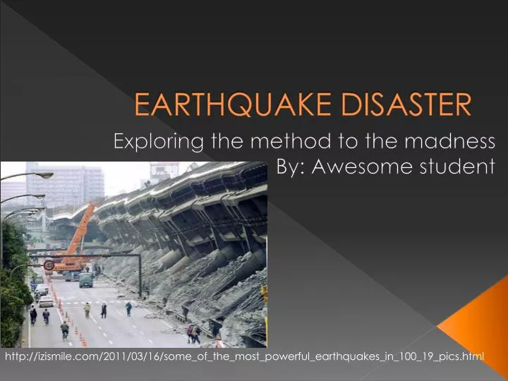
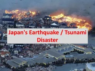
EARTHQUAKE DISASTER. Exploring the method to the madness By: Awesome student. http://izismile.com/2011/03/16/some_of_the_most_powerful_earthquakes_in_100_19_pics.html. EARTHQUAKE!.

E N D
EARTHQUAKE DISASTER Exploring the method to the madness By: Awesome student http://izismile.com/2011/03/16/some_of_the_most_powerful_earthquakes_in_100_19_pics.html
EARTHQUAKE! • Throughout this slideshow, we will be exploring earthquakes, how they occur, and how can we be more prepared for their coming. An earthquake is properly defined as: The result of a sudden release of energy in the Earth’s crust that creates seismic waves. http://pinoytutorial.com/lifebytes/wp-content/uploads/2010/03/chile-earthquake.jpg
The Causes of Earthquakes • There are four major parts of Earth: the inner core, the outer core, the mantle, and the crust. • The plates of Earth are always being moved around by the motion of the mantle, causing them to bump into, pull away, or slide past each other. • Earthquakes typically occur when two plate boundaries are moving towards each other, or sliding past each other. These are known as convergent and transform faults.
Where and Why? • 90% of the world’s earthquakes and 80% of the world’s most powerful earthquakes occur along the Pacific Ring of Fire. • The Ring of Fire is a zone in which earthquakes and volcanic eruptions occur frequently. It is shaped like a horseshoe and encircles the basin of the Pacific. It is associated with a nearly perpetual series of oceanic trenches, island arcs, and volcanic mountain ranges and/or plate movements. • The Pacific Ring of Fire exists because of its location directly above many of Earth’s plate boundaries. When these plate boundaries move past each other in different directions, at different speeds in the same direction, pull apart, or converge, earthquakes, volcanoes, and oceanic trenches can be direct results.
Earthquakes Specifically • Now that we’ve learned geographically where an earthquake is the most prevalent, how about the earthquake itself? • The earthquake’s point of initial rupture and most powerful point is known as its focus. • The epicenter of an earthquake is directly above the focus. http://earthguide.ucsd.edu/mystery_detectives/teach/epicenter/images/epicenter_focus.gif
Earthquake Terminology • Seismology: The study of earthquakes and seismic waves that move through and around the Earth. • The two main types of seismic waves are body waves, and surface waves. Body waves move through Earth’s inner layers, while surface waves move along the surface of the planet; similar to ripples on a lake. • The first kind of body wave is the P-Wave, or primary wave. These waves are the fastest kind, and are also known as compressional waves, because of how they push and pull the rock they move through. Click here for P-wave diagram. http://www.daviddarling.info/images/seismic_waves_inside_Earth.jpg
Earthquake Terminology • The second type of body wave is the S-Wave, or secondary wave. An S-Wave is the second wave felt in an earthquake; it travels slower than a primary wave. S-Waves cannot move through any liquid, only solid rock. S-Waves move rock particles perpendicular to the wave propagation. Click here for an S-wave diagram. http://pubs.usgs.gov/gip/earthq1/corel.gif http://www.cyberphysics.pwp.blueyonder.co.uk/graphics/diagrams/Earth/shadow_p_s.gif
Earthquake Terminology • Surface waves travel only through the crust of Earth. They are at a lower frequency than body waves, and arrive after them. However, it is these waves that are accountable for the ruin that earthquakes cause. In deeper earthquakes, the strength of these waves and damage they cause are reduced. • The two different surface waves are called love waves, and rayleigh waves. Love waves are named after a British mathematician, A.E.H. Love, who built a representation for this kind of wave in 1911. They are the fastest kind of surface wave and move the ground from side to side. They produce entirely horizontal movement because of their confinement to only the surface of the crust. http://www.dnr.mo.gov/geology/images/LoveWv.jpg
Earthquake Terminology • The second kind of surface wave, the rayleigh wave, is named for John William Strutt, Lord Rayleigh; who predicted this wave’s existence in 1885. • A rayleigh wave rolls along the crust of Earth, similar to the way a wave rolls along an ocean. Consequently, the ground moves up and down, or side to side, in the same direction that the wave is moving. This wave can be much larger than other waves. Most of the tremor, or shake in an earthquake is due to this kind of wave. http://www.exploratorium.edu/faultline/basics/images/rayleighlove_lrg.gif
Seismometers and Seismograms • A seismometer is a ground motion detection sensor. It is sensitive to movements of Earth, and can be understood by visualizing a weight hanging on a string. A frame that moves with the Earth’s surface suspends the spring and weight. As the earth moves, the movement between the weight and the earth provides a measure of the vertical ground motion. If a recording structure is installed, such as a revolving drum connected to the frame, and a pen attached to the weight, the motion between the weight and the Earth can be recorded, producing a seismogram. • Modern seismometers are electronic. The motion amid the weight and the frame generates an electrical energy that’s recorded by a computer. http://sydney.edu.au/science/uniserve_science/school/Seismograph/seismogram.jpg http://www.usarray.org/files/images/seismometer_tn.jpg
The Richter Scale • The Richter Scale was created by Charles F. Richter in 1935 to compare the size of earthquakes. The magnitude of an earthquake is determined by the measure of energy that is released. • “The Richter Scale is a numerical rating system that measures the energy of the largest seismic waves that are produced during an earthquake. The numbers are determined by the height (amplitude) of the wave as it travels through Earth.” -Laurie Haines http://www.lewistonpublicschools.org/~lhaines/FOV1-0003C686/FOV1-0003E815/FOV1-0003E817/FOV1-0003E81A/FOV1-0003D65D/S01900FE5.0/52409_2445228_0.gif?src=.PNG
The Modified Mercalli Scale • The Modified Mercalli Scale, or, MM Scale is intended to measure the intensity of earthquakes. It consists of specific key responses, like people awakening, and movement of furniture, to total demolition. There have been many intensity scales developed in the past several hundred years, the MM Scale is the one used in the United States. In 1931, seismologists Harry Wood and Frank Neumann developed this scale, which contains 12 different levels of intensity. These range from undetectable shaking, to cataclysmic ruin. This scale doesn’t have a mathematical basis, but is based on observed effects. http://scearthquakes.cofc.edu/images/MercalRichtscale.gif
Seismic Belts & Global Earthquake Epicenters • A seismic belt is a geographic region on Earth’s surface along which most earthquake activity occurs. The lithosphere (crust) is made up of several tectonic plates. Along the boundaries of these plates is where earthquakes often occur, and produce seismic belts. • As you can see from the information in the global earthquake epicenter location map, the locations nearly outline the plate boundaries of Earth, thus, giving significant evidence that our understanding of earthquakes is accurate. http://en.wikipedia.org/wiki/File:Quake_epicenters_1963-98.png http://www.learner.org/interactives/dynamicearth/images/new_map.jpg
Along what plate boundaries are earthquakes the most active? • Earthquakes are extremely active along faults. Faults are cracks in plates (or two plates) that are moving in different directions. Faults are most common near the edges of plates. • A normal fault (divergent fault) is when two plates of earth are moving away from each other, or when one plate is sliding downward and pulling away from another. • A reverse fault (convergent fault) is when two plates are moving towards each other. The plate of more mass will eventually be subducted under the plate of less density. • A transform fault (strike slip fault) occurs when two plates slide past one another in different directions, or in the same direction at different speeds. • When any two plates are moving toward, away from, or past each other, they initially stick together. As the pressure builds up in the plates, eventually the rock breaks and the release of energy causes seismic waves that make the ground shake. This is why earthquakes are most common along faults, and these faults specifically.
Earthquake Resistant/Resilient Buildings • Earthquakes are an extremely common occurrence in Japan. It’s for this reason that engineers have taken into special consideration, the building of structures that are earthquake resistant. These buildings are designed with flexibility and rather than sitting directly on the ground, sit atop a system of ball bearings, springs, and padded cylinders, that can reduce the impact earthquakes have on buildings. and can be compared to a paperclip; "you can bend it, and at some point it gives way but it doesn't break. And you can bend it over and it will stay in that misplaced shape.“ – Stephen Mahin, the director of Pacific Earthquake Engineering Research Center. • The most sophisticated building systems utilize fluid-filled shock absorbers that slosh a thick oil in the opposite direction of swaying. The Roppongi Hills, Mori Tower in Tokyo, Japan is constructed with such a design, and is the most resilient to damage. The Roppongi Hills, Mori Tower http://www.japan-i.jp/explorejapan/kanto/tokyo/roppongi-akasaka/4oa00l00000049zw-img/4oa00l0000004a0e.jpg http://jen.co/blog/wp-content/uploads/2011/03/Japan-Earthquake-March-11-2011.jpeg
Vibrations and Resonance • Every building has a natural vibration frequency. When an earthquake releases energy in the form of seismic waves, and these waves are of the same frequency and amplitude as the building’s natural vibration frequency, resonance can happen. This is the actual source of structural damage. http://sar.informatik.hu-berlin.de/research/projects/2006-EWS/Chi6.jpg http://www.thorlabs.com/tutorials/Table20.gif
Earthquake Preparedness and Warning Systems • Although we cannot predict exactly when an earthquake is going to occur, earthquake preparedness is designed to aid individuals in case of an earthquake event. Steps that you can take to assist you in an earthquake crisis are: always have a disaster supplies kit that is easily accessible, keep heavy objects in your home on the ground, and replace halogen and incandescent bulbs with fluorescent ones to reduce fire hazards. • An earthquake early warning system consists of many seismic motion sensors arranged in a region. High speed computers and communications systems collect the sensor readings and detect the magnitude and progression of the earthquake. When it is detected the system can transmit alarms throughout the region. • In California, an earthquake early warning system not only sounds alarms throughout the area, but turns off the gas in homes, starts back-up generators in local hospitals, and automatically rolls up the doors of fire stations! It operates based on the initial P-Wave that an earthquake sends out. Sensing it, the system can give forewarning before the S-Wave, or actual shaking, occurs. It allots about a one second warning for every five miles of the Earth’s crust that a location is from the epicenter, which in some areas is enough time to save lives. • The Japan EEW is very similar to that of California in that it too analyzes the P-Wave and roughly how far away the epicenter is located. It sends warnings out via radio and television if strong shaking is expected.
Answering Questions • Can we predict where and when an earthquake will occur? Due to earthquakes’ annihilating potential, many people have sought a way to predict where and when an earthquake event will occur. It is true that with the knowledge we have of plate tectonics and faults, we can predict where earthquakes are most likely to ensue; however, we cannot predict a date and a time. Though we can’t foresee specific earthquakes, the world’s largest ones have a clear pattern, therefore predictions of the locations and magnitudes of some future earthquakes can be made.
Answering Questions • Can we create an earthquake early warning system? Yes, in fact, the U.S. currently has a sophisticated earthquake early warning system in California. The system detects the P-Waves that arrive seconds before the S-Waves (the cause of the actual shaking) and sounds alarms, turns of the gas in homes, activates hospital back-up generators, and opens fire house doors! The system cost roughly $80 billion to run for five years says Richard Allen, associate director of the UC Berkeley Seismological Laboratory.
Answering Questions What might an earthquake early warning system look like? An earthquake early warning system would probably have accelerometers (device that measures acceleration), communication systems, computers, and alarms. The accelerometers would measure the rate of acceleration of the quake, then transfer that information on to a computer, when the computer received the information, it could set alarms and warnings off throughout the area that is predicted to be affected by it. Of course, these systems don’t give hours notice, but a couple seconds could be enough to protect yourself.
Answering Questions How can we better protect ourselves in the event of an earthquake? In the event of an earthquake, you should try to move heavy objects flat on the floor (refrigerators, mirrors, etc.) If there is not time to do these things, get under cover to protect yourself from any falling objects. If you are driving, slow down gradually, pull over and put your parking brake on, but do not exit the car! You should also take provisions such as, keeping an emergency kit that’s easily accessible.
In Conclusion • Earthquakes are an unavoidable natural force of destruction. Earthquakes mainly occur along plate boundaries and we can make generalizations, or “forecasts” of where they will occur, but not when. Engineers are constantly working to design earthquake resilient structures, and to retrofit older buildings. We’re a privileged people to have the knowledge to protect ourselves against this mass-murderer, and to have people who care enough to put their efforts into saving lives.
Works Cited "Early Quake Warning Possible Thanks to NorCal Company | NBC Bay Area." NBC Bay Area - Local News, Weather, Traffic, Entertainment, Events, Breaking News | NBC Bay Area. Web. 08 June 2011. "Earthquake Early Warning (Japan)." Wikipedia, the Free Encyclopedia. Web. 08 June 2011 "Earthquake Preparedness." Wikipedia, the Free Encyclopedia. Web. 08 June 2011. Ludwin, Ruth. "Earthquake Prediction Information." PNSN - Pacific Northwest Seismic Network. Web. 08 June 2011. "The Modified Mercalli Intensity Scale." U.S. Geological Survey Earthquake Hazards Program. Web. 08 June 2011. "Safety and Disaster Preparedness: Earthquakes - Kyoto Prefecture Multilingual Site." 京都府ホームページ Kyoto Prefecture Web Site. Web. 08 June 2011. "The Science of Earthquakes." U.S. Geological Survey Earthquake Hazards Program. Web. 08 June 2011. "Seismic Belt -- Britannica Online Encyclopedia." Encyclopedia - Britannica Online Encyclopedia. Web. 08 June 2011. Vastag, Brian. "Ongo | Japan a Leader in Engineering Earthquake-proof Structures, Helping to Limit Damage." Ongo | Welcome to Ongo. Your News like Never Before. Web. 08 June 2011. "What Is Seismology and What Are Seismic Waves?" Geological Engineering and Sciences at Michigan Tech. Web. 08 June 2011. "Where Do Earthquakes Happen?" Geological Engineering and Sciences at Michigan Tech. Web. 08 June 2011.

![Earthquake Prediction Research [EPR] & Disaster Management Strategy - M.V.Ramanamurthy .](https://cdn0.slideserve.com/1445558/slide1-dt.jpg)