Download
1 / 11
110 likes | 229 Views
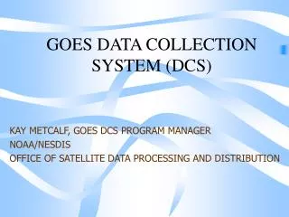
GOES Data Collection System. Kay Metcalf NOAA GOES DCS Program Manager 10 March, 2011. What is GOES DCS?. Near real time relay for the collection of environmental data from > 30,000 remote sites located throughout the Western Hemisphere Started as an experimental system in the 1970’s

E N D
GOES Data Collection System Kay Metcalf NOAA GOES DCS Program Manager 10 March, 2011
What is GOES DCS? • Near real time relay for the collection of environmental data from > 30,000 remote sites located throughout the Western Hemisphere • Started as an experimental system in the 1970’s • Evolved into a critical operational system used by many Federal, State ,Local and international agencies • Many Emergency warning systems in the U.S. and other countries rely on GOES DCS NOAA GOES DCS
How Does it Work? • Frequency Share/Time Share System • 400 khz of Bandwidth Assigned to GOES DCS • Divided into Approximately 200 channels of 1.5 khz • Each Transmitter Assigned a Channel/Time Slot • Standard Assignment is Hourly, for 10 seconds • Some report more frequently (NOS Tide Stations, Tsunami Warning Networks) • Some older stations still report every 3 or 4 hours • Random Reporting Mode Available • Event Driven • Emergency Use more frequent observations • Flooding event, fire breakout, earthquake, volcano eruption NOAA GOES DCS
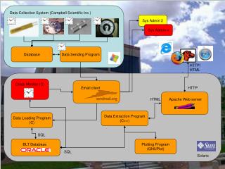
GOES DCS System Diagram NOAA GOES DCS
GOES DCS COVERAGE AREA NOAA GOES DCS
GOES DCS Users • Bureau of Reclamation • National Park Service • Department of State • (International Boundary & Water Commission) • Multiple State Agencies • Canadian Environmental Agencies • South and Central American Environmental Agencies • International Tsunami Warning Networks • > 400 Agencies • > 700 Programs • National Weather Service • largest single data user • National Ocean Service • Declared DCS critical infrastructure • National Climatic Data Center • National Data Buoy Center • Pacific Tsunami Warning Center • US Army Corps of Engineers • US Air Force • US Navy • Department of Interior • National Interagency Fire Center • National Forest Service • Bureau of Land Management • US Geological Survey • largest single platform operator NOAA GOES DCS
Applications • Flood Warning • Levy Management • Water Resource Management • Fire Warning and Monitoring • Tsunami Warning • Earthquake Monitoring • Volcano Monitoring • Weather Observations • Climate Monitoring • Water Level Monitoring NOAA GOES DCS
Hazard Monitoring Uses • U.S. Flood Data • USGS Stream Gauge Program • Approximately 10,000 stations • US Army Corps of Engineers Flood Monitoring • Approximately 3,000 stations • International Meteorological Services • Approximately 4,000 stations • Canada/Mexico (North America) • Central and South America • Atlantic/Caribbean • Pacific • Distributed Through the NWS HADS • http://www.nws.noaa.gov/oh/hads/ NOAA GOES DCS
Hazard Monitoring Uses • U.S. Fire Weather • Remote Automated Weather Station (RAWS) • Operated by USFS, BLM, state and local fire agencies • Estimated 4000 stations • National Standard for Fire Weather Data • Available through AWIPS • Available on the Internet • http://fire.boi.noaa.gov • http://raws.wrh.noaa.gov/rawsobs.html • http://www.fs.fed.us/raws NOAA GOES DCS
Who Can use the System? • Government User (federal, state, local, international) • Non-Profit User • Non-government User with Government Sponsor • Collectors of Environmental Data • Usage outlined by regulation NOAA GOES DCS
GOES DCS Contact Information • Kay Metcalf • GOES DCS Program Manager • kay.metcalf@noaa.gov • 301-817-4558 • Letecia Reeves • GOES DCS Customer Service Representative • letecia.reeves@noaa.gov • 301-817-4563 • Email • goes.dcs@noaa.gov • URL • http://noaasis.noaa.gov/DCS NOAA GOES DCS