Download
1 / 71
760 likes | 1.05k Views
Cities and Civilizations. World History Ch. 2 Early River Civilizations. GEOGRAPHY influenced the development of river valley civilizations. Advanced Cities. Advanced Technology. CIVILIZATION. Specialized Workers. Record- Keeping. Complex Institutions.

E N D
Cities and Civilizations World History Ch. 2 Early River Civilizations
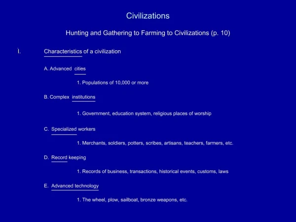
GEOGRAPHY influenced the development of river valley civilizations.
Advanced Cities Advanced Technology CIVILIZATION Specialized Workers Record- Keeping Complex Institutions
Mesopotamia – Fertile Crescent • Sumer – The Earliest of the River Valley Civilizations • Sumerian Civilization grew up along the Tigris and Euphrates Rivers in what is now Kuwait.
Look at the map in the textbook on page 30. “Fertile Crescent.”
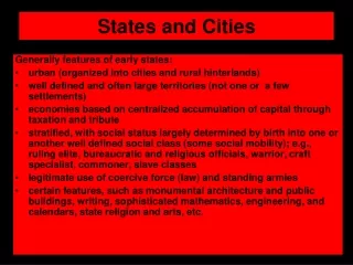
Geography Promotes Civilization • Fertile area between the Tigris and Euphrates rivers became site of world’s first civilization • Fertile Crescent well suited for agriculture • Farming in Mesopotamia posed challenges: • If water levels too high, crops washed away • If water levels too low, crops died • People developed methods to control water: • Basins, canals, and dikes • Organization: assigning jobs, allocating resources
Religion and Government • Shaped life in city-states • Polytheism: worship of many gods • Priests had high status and were the first rulers • War chiefs began to rule as kings • Dynasty: series of rulers from one family • Sumer
Sumerian Culture • Writing • Cuneiform: Sumerian writing • Business accounts and records • Law, grammar, literature • Scribes • Math and Sciences • System based on number 60 • Geometry • May have been the first to use the wheel • Invented the plow • Basic surgery • The Arts • Arches, ramps, columns • Sculpture • Cylinder seals • Trade and Society • Traded for wood and metals • Social hierarchy • Distinct male/female roles
Sargon’s Empire • The Babylonian Empire • Sargon I: • Around 2350 BC, created first permanent army • Conquered Sumer and northern Mesopotamia • Established world’s first empire, which lasted about 100 years • Sumerian culture spread far beyond Tigris and Euphrates valleys • Hammurabi became king in 1792 BC • United all of Mesopotamia • Able ruler and administrator • Hammurabi’s Code: • 282 laws covering everything from trade to murder • Written for all to see • Babylon became Mesopotamia’s greatest city • Empires in Mesopotamia • Each conquering invader adapted aspects of Sumerian culture. • Thus Sumerian civilization continued to influence life in Mesopotamia.
Sumer - Sumerians (Kuwait)ca. 3500 to 3000 BC.(ca. = circa) Sumer gave us the city-state. Define: city-state Political unit made up of a city and the surrounding lands. Each city state has its own government, even when it shares a culture with neighboring city states.
Sumerian Writing: cuneiform . Cuneiform is created by pressing a pointed stylus into a clay tablet.
Sumerians invented: • Brick technology • Wheel • Base 60 – using the circle . . . 360 degrees • Time – 60 minutes in an hour, 60 seconds in a minute • 12 month lunar calendar • arch • ramp • ziggurat
“If a man stole the property of church or state, that man shall be put to death;also the one who received the stolen goods from his hand shall be put todeath.” The laws governed such things as lying, stealing, assault, debt, business partnerships, marriage, and divorce. In seeking protection for all members of Babylonian society, Hammurabi relied on the philosophy of equal retaliation, otherwise known as “an eye for an eye.”
Ch. 2 Sect. 2 What did Herodotus mean when he said that Egypt is the “gift of the Nile?” Nile River Because of the geography of the area. Sahara Desert
The Geography of Egypt • Environmental Challenges • • Light floods reduce crops, cause starvation • • Heavy floods destroy property; deserts isolate and protect Egyptians • Upper Egypt and Lower Egypt • • River area south of First Cataract is elevated, becomes Upper Egypt • • Cataract—where boulders turn Nile River into • churning rapids • • River area north, including Nile delta, becomes Lower Egypt • • Delta—land formed by silt deposits at mouth of river; triangular • NEXT
Click the icon to play Listen to History audio. • Click the icon below to connect to the Interactive Maps.
Geography and Early Egypt • The Nile • Most important physical feature in Egypt • 4,000 miles long; flows through the Sahara Desert • Without the Nile’s waters, no one could live there. • Geography of Egypt • The Nile flooded every year • Predictable floodwaters with spring rains • Left rich, black silt • Narrow band of fertile soil • Became home of Egyptian civilization
Cataracts • Delta • Nile afforded protection itself • Flowed through cataracts to the south • Currents and waterfalls made sailing impossible • Not an easy invasion route • Egypt’s most fertile soil in Nile Delta • Silt deposits at mouth of river • Black Land of rich arable soil • Red Land unlivable but afforded protection • Geographical Features
Draw Conclusions • How did geography affect where the early Egyptians lived? • Answer(s): They lived in a narrow strip of fertile land where they could raise crops. It was surrounded by inhospitable desert, which would not easily support life.
Egypt Unites into a Kingdom King Narmer Creates Egyptian Dynasty • • Villages of Egypt ruled by two kingdoms—Lower Egypt, Upper Egypt • • King Narmer unites them around 3000 B.C.; makes Memphis capital • • Establishes first Egyptian dynasty Pharaohs Rule as Gods • • To the Egyptians, kings are gods; Egyptian god kings called pharaohs • • Pharaohs control religion, government, army, well-being of kingdom • • Government based on religious authority— theocracy • Continued . . . • NEXT
Egyptians invented: • Hieroglyphics • Pyramids • Geometry • Advances in medicine and surgery
Religion and Life • •Egyptians believe in 2,000 gods and • goddesses—polytheistic • •Reis sun god, Osiris, god of the dead; goddess • Isis is ideal woman • • Believe in life after death; person judged by deeds at death
Papyrus is one of the first examples of paper. It is created from reeds growing along the Nile River. • Egyptian Writing In hieroglyphics writing system, pictures • represent ideas • Paperlike sheets made from papyrus reeds used for writing
Hieroglyphics Early Egyptian writing found on tombs was indecipherable. Hieroglyphics Sacred Carving No one could read these sacred carvings until Napoleon invaded Egypt and his archaeologists found the Rosetta Stone.
In ancient Egypt, scribes used hieroglyphs to record state documents and important historical events. Hieroglyphs with religious purposes also were painted on tomb walls and wooden coffins, such as these hieroglyphs from the tomb of Queen Amonherkhepsef, located in the Valley of the Queens.
Ancient Egyptian Mummy
Ch. 2 Sect. III Review • 1. Which direction does the Nile flow? North • 2. What do we call a government based on religion? Theocracy 3. What is the Egyptian god king called? Pharoah 4. What is the belief in many gods? Polytheism 5. What do we call the Egyptian writing? Hieroglyphics
Indus River Valley (page 53)2500 BC – 1500 BC Ch. 2 Sect. III Around 2600 B.C. the various regional cultures were united in what is called the Indus Valley Civilization. It is also commonly referred to as the Harappan culture after the town of Harappa (where it was first discovered.) What made the Indus Valley a good place for a civilization?
Planned Cities on the Indus The Geography of the Indian Subcontinent Indian Subcontinent • • Subcontinent—landmass that includes India, Pakistan, and Bangladesh • • World’s tallest mountain ranges separate it from rest of Asia Rivers, Mountains, and Plains • • Mountains to north, desert to east, protect Indus Valley from invasion • • Indus and Ganges rivers from flat, fertile plain—the Indo-Gangetic • • Southern India, a dry plateau flanked by mountains • • Narrow strip of tropical land along coast • Continued . . . • NEXT
The Geography of the Indian Subcontinent Monsoons • • Seasonal winds—monsoons—dominate India’s climate • • Winter winds are dry; summer winds bring rain can cause flooding Environmental Challenges • • Floods along the Indus unpredictable; river can change course • • Rainfall unpredictable; could have droughts or floods • NEXT
Civilization Emerges on the Indus Indus Valley Civilization • • Influenced an area larger than Mesopotamia or Egypt • Earliest Arrivals • • About 7000 B.C., evidence of agriculture and domesticated animals • • By about 3200 B.C., people farming in villages along Indus River Planned Cities • • By 2500 B.C., people build cities of brick laid out on grid system • • Engineers create plumbing and sewage systems • • Indus Valley called Harappan civilization after Harappa, a city • NEXT
What do the planned cities of the Indus Valley people tell us about their culture? High level of cooperation, strong central government What skills were needed to build these planned cities? Central gov. building materials, engineering and architectural skills
Harappan Culture Language • • Had writing systems of 400 symbols; but scientists can’t decipher it Culture • • Harappan cities appear uniform in culture; no great social divisions • • Animals important to the culture; toys suggest prosperity • NEXT
Role of Religion • • Priests closely linked to rulers • • Some religious artifacts reveals links to modern Hindu culture Trade • • Had thriving trade with other peoples, including Mesopotamia Harappan Decline • • Signs of decline begin around 1750 B.C. • • Earthquakes, floods, soil depletion may have caused decline • • Around 1500 B.C., Aryans enter area and become dominant • NEXT
Excavations at the ancient Harappan and Mohenjo Daro mounds revealed well planned cities and towns built on massive mud brick platforms that protected the inhabitants against seasonal floods. In the larger cities the houses were built of baked brick while at smaller towns most houses were built of sun-dried mud brick. Each city is laid out in a grid pattern and shows signs of stunningly modern plumbing systems. Much writing has been found at these sites, but it has not yet been translated.
Sect. III Review • 1.What environmental challenges do the people of the Indus face? • Yearly floods, rivers change course, monsoons unpredictable too much rain or not enough. • 2. Was the geography of Mesopotamia or Egypt more like that of the Indus Valley? • Mesopotamia b/c the floods were unpredicable. • 3. What environmental challenges did the people of the Indus face that the first 2 didn’t? • The Monsoons
Shang China1600 BC – 1122 BC Ch. 2 Sect. IV Lack of contact with foreigners helped give the Chinese a strong sense of identity and superiority. They regarded their land as the only civilized land and called it Zhongguo or the Middle Kingdom. This Chinese isolation contributed to the Chinese belief that China was at the center of the earth and the sole source of civilization.
Mongolian Plateau • Taklimakan Desert • Gobi Desert • Plateau of Tibet • Pacific Ocean • Himalaya Mountains North, South , East, West Natural barriers isolated China from all other civilizations.
Click Red Stars to find more information. • United States • China • In an effort to balance the relationship between land and people, China adopted a “one-couple, one-child” policy in the 1980’s. • US Agricultural Production China: Size and Population • 9,596,960 Square area • 9,629,091 Square area • 1,284,303,705 Population • 280,562,489 Population • The population of China is more that one billion people, the largest national group in the world. Two-thirds of the Chinese people are farmers, but only 4% of China’s land can be cultivated.