Download
1 / 64
710 likes | 1.07k Views
Current and Future Remote Sensing Systems Lecture 2. Prof. Dr. Scott Madry Research Associate Professor, University of North Carolina, USA. Current and Future Remote Sensing Systems. Resolution. Four kinds of resolution define user needs:

E N D
Current and Future Remote Sensing SystemsLecture 2 Prof. Dr. Scott Madry Research Associate Professor, University of North Carolina, USA
Resolution Four kinds of resolution define user needs: Spatial Resolution: How small an object do you need to see (pixel size) and how large an area do you need to cover (swath width) Spectral Resolution: What part of the spectrum do you want to measure Radiometric Resolution: How finely do you need to quantify the data (6 bit=0~63, 8 bit=0~255, 10 bit=0-1023) Temporal Resolution: How often do you need to look
How good can we get? • A 2 meter mirror in orbit gives a theoretical limit of about 2 inches (degraded by wind, smog, etc.) • SALT-II treaty said existing ICBMs could not be altered more than 5% in diameter • Smallest Soviet ICBM then was SS-11, 6 feet (~2 m) in diameter, 5% is 3.6 inches (10 cm) • US would not sign a treaty that it could not routinely verify by National Technical Means…
MSS bands 6 and 7 Water absorbs IR energy-no return=black INFRARED 1 INFRARED 2
Swath width Landsat-185 km (100 mi) 80 m = 40 MB-4 bands (MSS) 30 m = 320 MB-6 bands (TM) 10 m = 342.25 MB-1 band 5 m = 1.369 GB -1 band 1 m = 34.225 TB – 1 band How small do we need? How much data can we store And process?
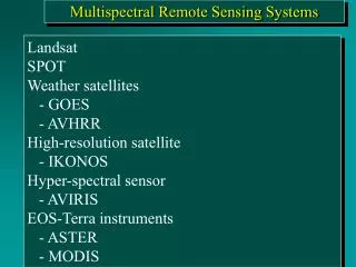
Remote Sensing Systems There are many ways remote sensing is used: Geostationary weather monitoring Polar remote sensing National security, cartography and mapping Natural resource management Disaster management-fire, earthquakes, etc. Data for Geographic Information Systems (GIS) Atmospheric and Marine science and applications Earth systems science, and many, many others New hi-resolution systems are equal to aerial photos
Polar orbiting remote sensing Polar orbit is 700-900 km constant sun angle 1,000-1m resolution NOAA Polar Orbiters and Russian Meteors are Public environmental satellites-data in the clear Many other new national and commercial systems encrypt their data
Applications-Change Detection The ability to monitor change is one of the benefits of remote sensing We can monitor human and natural changes in the landscape
Thermal imagery-temperature Water analysis-nuclear power cooling ponds Real time fire management
New RS Many new systems are in development New gov’t and Commercial systems as well
NOAA POES Polar Orbiting Environmental Satellite Two satellites in orbit One satellite crosses the equator at 7:30am local time, the other at 1:40pm local time. Advanced Very High Resolution Radiometer (AVHRR) sensor
Global vegetation productivity AVHRR-land CZCS phytoplancton-water Remote sensing provides global information about the health of spaceship Earth
SeaWiFS Aug ‘97 launch Swath Width 2,801 km LAC/HRPT (58.3 degrees) Swath Width 1,502 Km GAC (45 degrees) Spatial Resolution 1.1 km LAC, 4.5 km GAC Real-Time Data Rate 665 kbps Revisit Time 1 day Digitization 10 bits
Defense Meteorological Program Satellite (DMSP) The Defense Meteorological Satellite Program (DMSP) is a DOD program. OLS- Operational Linescan System Similar to AVHRR but with unique low light night imager 4 satellites (3 day/night, 1 dawn/dusk)
The Landsat Program-First Civil RS The Landsat program was the first civil RS program 1965: NASA initiates an Earth Resources Survey (ERS) Program to develop methods for remote sensing of earth resources from space. Dept. of Agriculture joins in the program with studies of remote sensing applications in geology, hydrology, geography and cartography. ‘72 launch of ERTS-1 (Earth Resource Technology Satellite) Multi-Spectral Scanner-80 m Landsat 2 and 3 were similar Landsat 4 and 5 had new Thematic Mapper (TM) 30m Landsat 6 went swimming Landsat 7 has 15 m by NASA for Mission to Planet Earth. Data is provided at cost (about US$ 250 per scene). Landsat 8? Will follow 7 for continuity? Data buy? NPOESS?
ERTS-1 Earth Resources Technology Satellite-1 NASA Renamed Landsat (Seasat) First images in late 1972 Was the first civil remote sensing satellite Based on the Nimbus bus