Download
1 / 16
170 likes | 302 Views
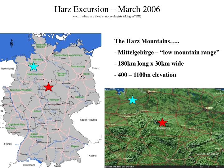
Harz Excursion – March 2006 ( or …. where are these crazy geologists taking us??!!!). The Harz Mountains….. Mittelgebirge – “low mountain range” 180km long x 30km wide 400 – 1100m elevation. Geology of the Harz.

E N D
Harz Excursion– March 2006(or…. where are these crazy geologists taking us??!!!) • The Harz Mountains….. • Mittelgebirge – “low mountain range” • 180km long x 30km wide • 400 – 1100m elevation
Geology of the Harz - formed by tectonic uplift 140Ma – 70Ma- consists of rather old rocks surrounded by younger rocks- all major rock types present (igneous, sed., and meta.)- “klassische oder goldene Quadratmeile der Geologie" Goethe, 1784 • Mining in the Harz • sulfidic lead (Pb) and zinc (Zn) ores • gold and silver coined in Goslar
408 – 360 Ma – Devonian Period • sharks, bony fishes appeared • oceans dominated by reef builders • - first amphibians • - first seed plants (earliest trees) • late Devonian extinction had little effect on land • 22% marine families, 57% marine genera
350 - 285 Ma – Carboniferous Period • early climate is warm, lush plant growth • hydrocarbons • O2 levels highest in history of earth (35%?) • amphibians colonize land, dominate • amniote egg allows certain tetrapod amphibians to • give rise to synapsids and reptiles • Gondwana moves south and climate cools
285 – 245 Ma – Permian Period • - Formation of supercontinent Pangea • - first time continental area > oceanic area • therapsids and gymnosperms dominate land, drier • largest extinction with two pulses • 1st coincides with glacial pulse • 2nd larger, fast, >80% species die • causes – flood basalts, anoxic pulse, impact?
Middle Devonian, 385 Ma b.p. clastic sediments in basin mafic extrusives at rifts carbonate reefs on highs Upper Carboniferous, 305 Ma b.p. Intense deformation (folding) during Variscan Orogeny
End of Upper Carboniferous, 300 Ma b.p. Intrusion of felsic magmas of Brocken and Ramberg plutons, contact metamorphism turns sedimentary country rocks into hornfels, first vein mineralization Permian (Rotliegendes), 280 Ma b.p. weathering and erosion, deposition of sediment in intramountaneous basins and in the foreland
Upper Permian / Triassic, 250 Ma b.y. erosion to peneplain below sea-level, formation of evaporites (carbonates and salts) under arid climate Upper Cretaceous, 80 Ma b.p. renewed uplift! younger sequences surrounding the Hars Mts. are folded, tilted and dragged upwards, contineous erosion removes post-Carboniferous rocks and exposes granite plutons
Re-newed uplift in the Upper Cretaceous exposes pre-Permian rocks of the Hars Mts. and drags post-Carboniferous rocks upwards