Download
1 / 14
140 likes | 262 Views
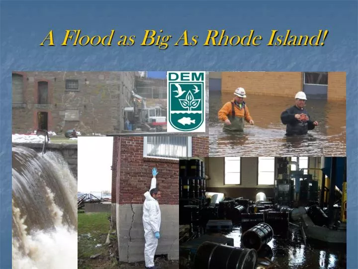
A Flood as Big As Rhode Island!. Background-Flood Timeline. Flood was a two-stage event March 12-15, 2010 First event- 4-6” of rain/hurricane force winds Pawtuxet River crests at 14.98 feet, 5 feet above flood stage and a historic record March 28-April 1, 2010 Second event-8”-12” of rain

E N D
Background-Flood Timeline • Flood was a two-stage event • March 12-15, 2010 • First event- 4-6” of rain/hurricane force winds • Pawtuxet River crests at 14.98 feet, 5 feet above flood stage and a historic record • March 28-April 1, 2010 • Second event-8”-12” of rain • Pawtuxet River crests at 20.79 feet
Scope of DEM Involvement • Overall Unified Command/ICS • Dam Safety • Wastewater Treatment Plant Inundation • Oil and Petroleum Releases • Debris Management • Sediment Characterization & Management • TSDF Impacts • UST Impacts
Overall Unified Command/ICS • Emergency Operations Center activated at State Emergency Management Agency • Web EOC activated for needs/assignments • Emergency Support Functions: • Oil and Haz Mat Response • Public Works- Dam Safety • Debris Management • DEM Agency Desk • Wastewater Recovery TF under Operations
Dam Safety • 42 Inspections at 33 dams • 4 dam breaches • Laurel Avenue-”Signature Site of Crisis” • Staff supplemented by Army Corps of Engineers
Wastewaster Treatment • 2 major plants inundated • Several pump stations impacted • Major downstream risk- water contaminated with sewage • Electronics destroyed • Recovery linked to energy efficiency
Oil and Haz Mat Releases • 170 locations • Lots of loose containers and tanks • Gas cylinders • Many releases inside structures
Debris Management • Extended Landfill and Transfer Station Hours • Household Hazardous Waste Advisories • Segregation of “Green” vegetative wastes • Marine debris
Sediment • Downstream outlet of Pawtuxet River- 18,000 cubic yards of sediment deposited in cove • Concerns about entrainment/deposition of historical contamination • Advisory on treatment with lime- sewage contamination • Strategies for response • Check all known sites for releases/impacts • Respond to all releases discovered • 29 recreation fields underwater- 111 acres • Municipal sampling • Providence-Dioxin (upstream NPL site) • PCB, TPH, Metals, PAH • Street sweepings advisory
Impacted TSDF • Safety Kleen • Activated contingency plan • Relocated drums/wastes • Submerged: • Lab • Records • No releases
USTs • 55 impacted facilities • All inspected post-flood • No major issues • No critical damage • No releases
Lessons Learned • Communications-Getting the word out • Supplemental staffing- back ups for programs expected for response • Planning- Hurricane exercises were very valuable • Working with federal agencies- regular partnerships vs. Stafford Act protocols • Issues with FEMA pre-approvals • Community Expectations of FEMA- can impact all operations.