Download
1 / 20
200 likes | 344 Views
Satellite-based overshooting top detection methods: comparison and validation. Petra Mikuš, Nataša Strelec Mahović Meteorological and Hydrological Service, Croatia. 1/1 5. Outline. On Overshooting tops (OT) Satellite based detection methods Weather conditions in the vicinity of the OTs

E N D
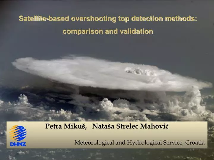
Satellite-based overshooting top detection methods: comparison and validation Petra Mikuš, Nataša Strelec Mahović Meteorological and Hydrological Service, Croatia
1/15 Outline • On Overshooting tops (OT) • Satellite based detection methods • Weather conditions in the vicinity of the OTs • Conclusions Croatian–USA Workshop on Mesometeorology 18 - 20 June 2012, Croatia
2/15 On Overshooting Tops • domelike protrusions above thunderstorm’s anvil • often penetrating into lower stratosphere • manifestation of very strong updraft • existing for less than 30 min • diameter ~ 15 km • vertical extant: up to about 2-3 km Croatian–USA Workshop on Mesometeorology 18 - 20 June 2012, Croatia
3/15 Croatian–USA Workshop on Mesometeorology 18 - 20 June 2012, Croatia
4/15 OT appearance in satellite images: Sandwich product: HRV + color-enhanced IRW 10.8 μm HRV Storm top plume OT Croatian–USA Workshop on Mesometeorology 18 - 20 June 2012, Croatia
THERMAL FEATURES: color-enhanced IR 10.8 μm 5/15 COLD RING COLD U/V Cold U shape Cold ring Close-in warm area Central warm area Distant warm area All the other storm top features result from the activity of OTs: cold ring, cold U/V, storm top plumes, storm top gravity waves…!!! Croatian–USA Workshop on Mesometeorology 18 - 20 June 2012, Croatia
6/15 Sendwich product: HRV + color-enhanced IRW Croatian–USA Workshop on Mesometeorology 18 - 20 June 2012, Croatia
7/15 Satellite-based detection methods • Channel differences: • 6.2 – 10.8 µm (WV-IRW) • 9.7 – 10.8 µm (O3-IRW) • 13.4 – 10.8 µm (CO2 – IRW) • COMB– combination of the WV-IRW and O3-IRW methods Croatian–USA Workshop on Mesometeorology 18 - 20 June 2012, Croatia
8/15 • COMB: WV-IRW & O3-IRW: • - combination of two BTD criteria • the smallest number of false alarms CO2 - IRW BTD WV – IRW BTD : False OT detections occur in the plume region O3 - IRWBTD: This method is depending on the annual ozone cycle – in May BTD thresholds should be higher Croatian–USA Workshop on Mesometeorology 18 - 20 June 2012, Croatia
9/15 • Locations of the OTs defined by mentiond BTD methods were compared with visually observed OTs on HRV images • July 2009, between 15 and 16 UTC (five SEVIRI scans) Table: Percentage of the OT pixels detected using three different BTD methods corresponding to OTs visible on HRV images. Croatian–USA Workshop on Mesometeorology 18 - 20 June 2012, Croatia
10/15 • OTs were detected using COMB BTD method • number of OTs was calculated over 0.2° x 0.2° grid boxes • warm seasons 2009 and 2010 (May-September) Croatian–USA Workshop on Mesometeorology 18 - 20 June 2012, Croatia
11/15 Comparison with automatic station data • parallax correction → applied to automatic station location Croatian–USA Workshop on Mesometeorology 18 - 20 June 2012, Croatia
12/15 automatic station Weiz, Austria temperature humidity max. wind precipitation Croatian–USA Workshop on Mesometeorology 18 - 20 June 2012, Croatia
13/15 • Wind gust • Precipitation (10-min amount) • Temperature drop Croatian–USA Workshop on Mesometeorology 18 - 20 June 2012, Croatia
14/15 Conclusions • COMB BTD method has been found to be the most appropriate BTD method for detecting the OTs, showing the smallest number of false alarms • gale wind gusts and significant 10-min precipitation amount are observed in the vicinity of the OTs • OT is only one of many possible indicators for severe weather conditions that can be seen in the satellite images (cold ring or cold U/V, right-moving storm, above anvil plume…) Croatian–USA Workshop on Mesometeorology 18 - 20 June 2012, Croatia
15/15 Thank youforyour attention! petra.mikus@cirus.dhz.hr natasa.strelec.mahovic@cirus.dhz.hr Croatian–USA Workshop on Mesometeorology 18 - 20 June 2012, Croatia
Figure: Map of the study domain with locations of the automatic stations used for this study (black square).
Table: Total number of the OTs detected using COMB BTD method within 0,1° radius from the automatic stations measuring mentioned parameters, compared to the number of OTs matching the measured extremes. Correlation between the OTs and each measured parameter is given in the last column.
Table: Number of OT detection using COMB method from May to September 2009 and 2010. Figure: Relative frequency of OTs, detected using COMB method, within given hour.