Download
1 / 21
210 likes | 352 Views
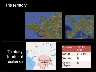
The territory. To study territorial resilience. Arrondissement de Nantes. The project. Find a «resilience index» for a territory face to major natural and industrial hazards in the future : other risks and threats... A qualitative «index»

E N D
The territory To study territorial resilience Arrondissement de Nantes
The project • Find a «resilience index» for a territory face to major natural and industrial hazards • in the future : other risks and threats... • A qualitative «index» • Mixing prevention, planning, preparedness, risk education, emergency management, economical and social resilience and recovery • Based on «global view» on a territory • Objectives : optimize a costly system of “reparation” 2
Feb 2010 Xynthia Storm : 53 Deaths Bad prevention “implementation” Good emergency response Poor resilience response Population unhappy Law suits ….. – big losses
Stakes Intensity Vulnerability How to implement Societal Resilience ? Frequency Anticipation Governance Preparedness Consciousness
Searching for an Index : How do weproceed ? • Defining a « gravity » mark for the territoryincluding : • natural and technologicalhazards (occurency&intensity) • stakesatrisk (importance &vulnerability)
Searching for an Index : Defining an “ability to react” mark for the territory :Studying all kind of prevention process – emergency planning & preparedness - education –assurance – communication – relationship between stake-holders… How do weproceed ?
Searching for an Index : How do weproceed ? Resilience index : “Ability to react” mark “Gravity” mark If > 1 Resilience positive If < 1 territory still at risk. But an index >1 does not mean all the work is done !
Beyond the Index : Increasing territorial resilience Beside rating the resilience, wealso focus on highlighting the ways to reinforceresiliencewith the best economic efficiency. So the territorial resilience index must be a qualitative index !
STAKES The gravity mark 5 People Economy Environment Heritage 4 3 2 GRAVITY Level expected Level reached 1 INTENSITY 1 2 3 4 5 0 5 4 3 2 1 FREQUENCY 1 Number of disasters that occured 2 3 Perception of one-self exposition Known by studies 4 VULNERABILITY 5
The ability to react mark CONSCIOUSNESS 5 Risk education Risk information 4 3 ABILITY TO REACT 2 Intervention planning Exercises Training / Formation 1 PREPAREDNESS 1 2 3 4 5 0 5 4 3 2 1 ANTICIPATION 1 Prevention planning Vigilance Warning 2 Politician commitment Budgets Inter-actor relationship Skills Financial cover Social cohesion 3 4 GOVERNANCE 5
Beyond the Index : 5 5 4 4 3 3 Reactivity = 24 ABILITY TO REACT 2 2 GRAVITY 1 1 1 1 2 2 3 3 4 4 5 5 0 0 5 5 4 4 3 3 2 2 1 1 Resilience Index would be 1.5 1 1 Gravity = 16 2 2 3 3 4 4 5 5
STAKES Beyond the Index : 5 5 CONSCIOUSNESS 4 4 3 3 over reactive ABILITY TO REACT 2 2 GRAVITY INTENSITY 1 1 PREPAREDNESS 1 1 2 2 3 3 4 4 5 5 0 0 5 5 4 4 3 3 2 2 1 1 FREQUENCY 1 1 ANTICIPATION Under reactive 2 2 3 3 Less and more We need to be less vulnerable and more reactive 4 4 VULNERABILITY GOVERNANCE 5 5
How do wecollect data : The inquiries • Interview with the persons in charge of major natural and technologicalhazards in : • Of course, besideourownresearch.
First study (2010-2011) : The area
First study (2010-2011) : The results • Unequal level of prepardnessbetweenstakeholders. Low for cities, higher for local administration • Low level of communication on natural and technologicalhazardsmatters • Weakgovernance. Not enough intercourse betweenactors. Low budgets dedicated.
Second study (2011) : The area
Second study (2011) : Course of action • Upgrading the methodology. • Collecting information by questionnaire and inquiries • Information processing (november-december 2011) • Final report redaction (december 2011) Study is on going !
Second Study Delivery : January 2012 • Second approach to see « validity » of the concept facing field reality • Supported by the Ministry of Ecology and Sustainable Development
Thankyou for your attention Léo Muller With the support Jacques FAYE responsable du bureau de l’information préventive, de la coordination et de la prospective Service des risques naturels et hydrauliques Direction générale de la prévention des risques Ministère de l’écologie, de l’énergie, du développement durable et de la mer
10 key points to achieve Resilience Reduce Gravity 1. Risk and vulnerability assessment 2. Taking care of risks in economic development 3. Insurances policy 4. Prevention & Preparedness 5. Risk education Reinforcing Response 6. Warning People may be affected 7. Safety of people and goods 8. Business continuity 9. Manage Emergency/Crisis Management (and post) 10. Planning economic resilience
Risque, aléas (p+i) , Enjeux (I+V) • Risque mesuré (=qualifié) de 0 à 100 soit (5+5)*(5+5) • Le risque est classifié (selon une échelle de 1 à 6) qui donne des appréciations sur la gravité • La gravité se mesure par le produit (p+i)*(I+V) • Pour réduire la gravité : renforcer la réactivité • Réactivité = « anticipation » (= vigilance et préparation) & « culture du risque » (= conscience et confiance) • On a donc réactivité = (v+p) * (c+c), à savoir 5+5 * 5+5 • On a donc 2 indicateurs : GRAVITE et REACTIVITE, données chiffrables. • Indice de résilience : REACTIVITE/ GRAVITE • Si indice > 1 alors résilience positive pour le territoire • Si indice < 1 risque pour le territoire • Rôle de « ERIS » ?