Download
1 / 2
30 likes | 176 Views
Road Impact Assessment in Land-use Change using Remote Sensing T rans-Chaco H ighway in P araguay. Karolina Argote 1 ,Louis Reymondin 1 , Andy Jarvis 1 . 1 International Center for Tropical Agriculture, Cali-Colombia. Abstract. Methodology.

E N D
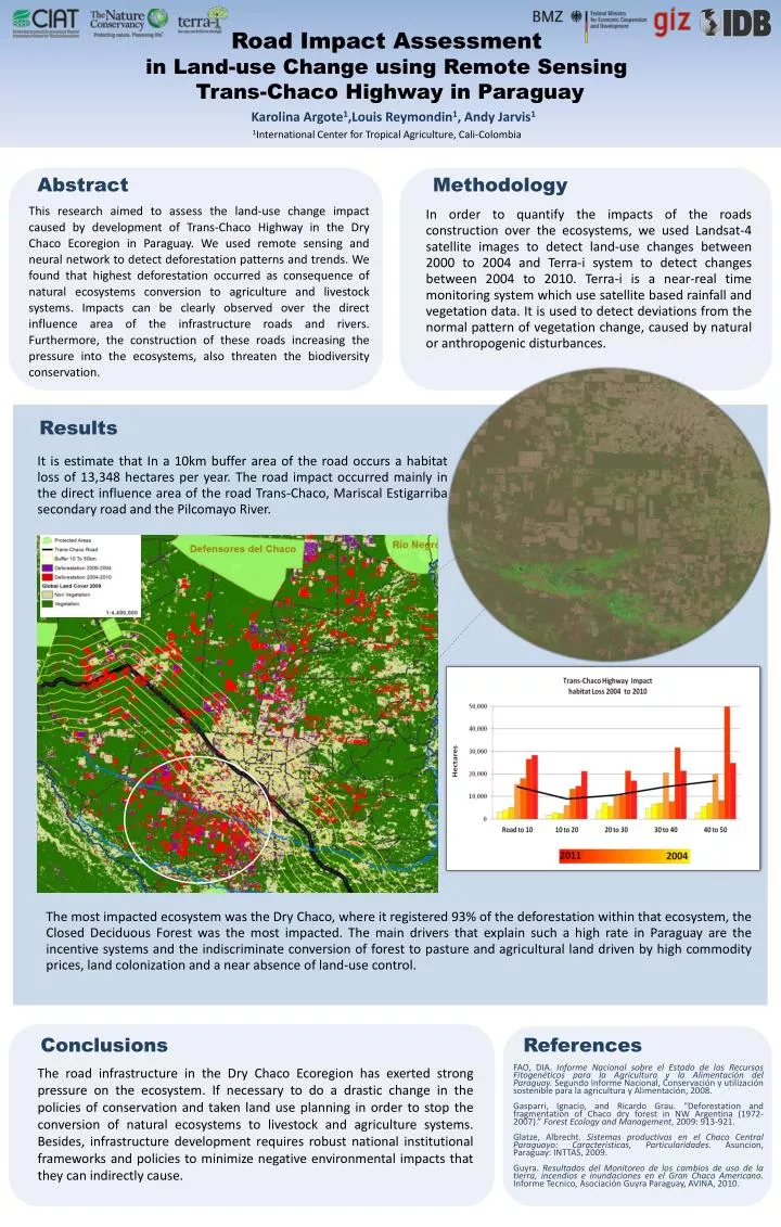
Road Impact Assessment in Land-use Change using Remote Sensing Trans-Chaco Highway in Paraguay Karolina Argote1,Louis Reymondin1, Andy Jarvis1 1International Center for Tropical Agriculture, Cali-Colombia Abstract Methodology This research aimed to assess the land-use change impact caused by development of Trans-Chaco Highway in the Dry Chaco Ecoregion in Paraguay. We used remote sensing and neural network to detect deforestation patterns and trends. We found that highest deforestation occurred as consequence of natural ecosystems conversion to agriculture and livestock systems. Impacts can be clearly observed over the direct influence area of the infrastructure roads and rivers. Furthermore, the construction of these roads increasing the pressure into the ecosystems, also threaten the biodiversity conservation. In order to quantify the impacts of the roads construction over the ecosystems, we used Landsat-4 satellite images to detect land-use changes between 2000 to 2004 and Terra-i system to detect changes between 2004 to 2010. Terra-i is a near-real time monitoring system which use satellite based rainfall and vegetation data. It is used to detect deviations from the normal pattern of vegetation change, caused by natural or anthropogenic disturbances. Results It is estimate that In a 10km buffer area of the road occurs a habitat loss of 13,348 hectares per year. The road impact occurred mainly in the direct influence area of the road Trans-Chaco, MariscalEstigarriba secondary road and the Pilcomayo River. The most impacted ecosystem was the Dry Chaco, where it registered 93% of the deforestation within that ecosystem, the Closed Deciduous Forest was the most impacted. The main drivers that explain such a high rate in Paraguay are the incentive systems and the indiscriminate conversion of forest to pasture and agricultural land driven by high commodity prices, land colonization and a near absence of land-use control. Conclusions References The road infrastructure in the Dry Chaco Ecoregion has exerted strong pressure on the ecosystem. If necessary to do a drastic change in the policies of conservation and taken land use planning in order to stop the conversion of natural ecosystems to livestock and agriculture systems. Besides, infrastructure development requires robust national institutional frameworks and policies to minimize negative environmental impacts that they can indirectly cause. FAO, DIA. Informe Nacional sobre el Estado de los Recursos Fitogenéticos para la Agricultura y la Alimentación del Paraguay. Segundo Informe Nacional, Conservación y utilización sostenible para la agricultura y Alimentación, 2008. Gasparri, Ignacio, and Ricardo Grau. “Deforestation and fragmentation of Chaco dry forest in NW Argentina (1972-2007).” ForestEcology and Management, 2009: 913-921. Glatze, Albrecht. Sistemas productivos en el Chaco Central Paraguayo: Caracteristicas, Particularidades.Asuncion, Paraguay: INTTAS, 2009. Guyra. Resultados del Monitoreo de los cambios de uso de la tierra, incendios e inundaciones en el Gran Chaco Americano.InformeTecnico, AsociaciónGuyra Paraguay, AVINA, 2010.
Road Impact Assessment in Land-use Change using Remote Sensing in Latin America Karolina Argote1,Louis Reymondin1, Andy Jarvis1 1International Center for Tropical Agriculture, Cali-Colombia Abstract Methodology The goal of this research was to assess the land-use change impact of highways development in five LA countries: Brazil, Peru, Panama, Bolivia and Paraguay. We used remote sensing and neural network techniques to detect deforestation patterns and trends. We found that highest impact inside the buffer area between 0 to 10km in each road. Furthermore, the construction of these roads near or into protected natural areas are increasing the pressure into the ecosystem and threaten the biodiversity conservation. In order to quantify the impacts of the roads construction over the ecosystems, we used Landsat satellite images to detect land-use changes before 2004 and Terra-i system between 2004 and 2011. Terra-i is a near-real time monitoring system which use satellite based rainfall and vegetation data. It is used to detect deviations from the normal pattern of vegetation change, caused by natural or anthropogenic disturbances. Results BR-364 Highway, Brazil Pan-American Highway, Panama In a 10km buffer area of the road occurs a deforestation rate of 6,656 ha/year in Cruzeiro do Sul -Rio Branco Segment in Acre and 15,771 ha/year around the Rio Branco-Porto Velho Segment in Rondonia. The impact of the BR-364 Highway is less in Acre, due to the conservation policies implemented in Acre state seems to be much more effective. The main drivers of change in these two states are the extension of livestock areas, and the implementation of large monoculture farms, particularly soybeans. In a 10km buffer area of the road occurs a habitat loss rate of 5,800ha/year. This deforestation is localized mostly in the provinces of Panama and Darien. The impact occurs mainly in the direct influence area of the road and shows that the impact is greater the closest it’s to the road. The Darien province lost 24% of its forests, and Panama 23%. Most of this deforestation occurred in Mixed Cative forest in order to create new cropland areas. Trans-Chaco Highway, Paraguay IIRSA Roads, Peru In a 10km buffer area of the road occurs a habitat loss rate of 13,348ha/year. The road impact occurs mainly in the direct influence area of the road Trans-Chaco, MariscalEstigarriba secondary road and the Pilcomayo River. The most impacted ecosystem was the Dry Chaco, where it registered 93% of the deforestation within this ecosystem, the Closed Deciduous Forest was the most impacted. The main drivers are the incentive systems and the indiscriminate conversion of forest to pasture and agricultural land driven by high commodity prices, land colonization and a near absence of land-use control. In a 10km buffer area of the road occurs a deforestation rate of 2,464ha/year in Patia-Tarapoto Segment, 1,148 ha/year in Tarapoto-Tingo Maria and 1,523ha/year in Tingo Maria-Cruzeiro do Sul. In the Peruvian Amazon, deforestation increases in the medium and long term while roads or pathways are built, or on the edge of rivers due to human settlement and shifting to cultivation. Santa Cruz-Puerto Suarez Road, Bolivia In a 10km buffer area of the road occurs a habitat loss rate of 3,079ha/year. This is mainly due to forest fires that occurred during this year, according with the official data. The road causes an indirect impact in the habitat due to the ease of access to markets and increased mobility that allowed other drivers to affect habitat change. The most important driver is an unsustainable agricultural practice called “slash and burn.” Conclusions Acknowledgements This Consultancy Project was conducted by the International Center for Tropical Agriculture (CIAT), the Nature Conservancy (TNC), and the Conservation Biology Institute (CBI) for the Environmental and Social Safeguards Unit of the Inter-American Development Bank. This project was supported with funds from the German Federal BundesministeriumfuerwirtschaftlicheZusammenarbeit und Entwicklung (BMZ) in the framework of a cooperation program between the Inter-American Development Bank (IDB) and the Deutsche GesellschaftfuerInternationaleZusammenarbeit (GIZ). It is clear that the development of road infrastructure have a positive impact on economic growth, but if does not take into account proper environmental management and establishing appropriate mitigation and conservation strategies before and after the construction can be generated negatives impacts on ecosystems such as the alteration of vegetation cover, habitat modification, hydrologic alteration and loss of biodiversity, among others.