Download
1 / 24
240 likes | 424 Views
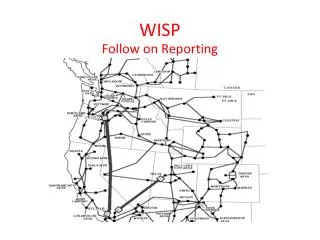
WISP Water Information Sharing Platform. Chris Seremet Technical Advisor – Water Supply and Sanitation March 30, 2011 ICT4 Development Conference Lusaka, Zambia. Introduction. Chris Seremet Technical Advisor – Water Supply and Sanitation Based in PQSD at HQ. Project Background.

E N D
WISP Water Information Sharing Platform Chris Seremet Technical Advisor – Water Supply and Sanitation March 30, 2011 ICT4 Development Conference Lusaka, Zambia
Introduction • Chris Seremet • Technical Advisor – Water Supply and Sanitation • Based in PQSD at HQ
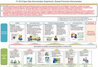
Project Background • WISP will link together the field data collection tools, with local and regional GIS databases, and expose the database content through reports and map viewers to any authorized agencies and donors, over the world wide web • Systems to be used for project planning and M&E purposes
Project Background • Ease of populating a database and generating reports and maps from data • Pilot in Kenya and possibly Ethiopia
WATERInformation Sharing Platform • Coordination Improvement Areas • ICT4D Investments by WVI and CRS • Millennium Water Alliance • Hydrologic Relationships (Topology)
WaterINFORMATIONSharing Platform • System Design • Ease of Use • Operational Constraints • Database Design • Data Collection • Data Management
Water Information SHARINGPlatform • Information Sharing • Geographic Integration • Federated Information Sharing / Replication • Transparency • Collaboration • Hydrographic Basemap
Water Information Sharing PLATFORM • Enterprise GIS • Organizational Scaling • User Community • Platform Scaling • Open Architectures • Interoperability • Developer Support • Technical Support
ICT Solution • NetHope, ESRI, World Vision, and the Millennium Water Alliance • PDAs, ArcGIS, FormBuilder • IT and staff support provided by NetHope and ESRI
Project Background Custom Web Dashboards Connected or Disconnected Field Data Collection ArcGIS OnlineGroups and Web Mapping OfflineField Solution ArcGIS Mobile Connected Mobile Clients ArcGIS .com ArcGIS APIs for Silverlight(Flex, Javascript, SharePoint) Full Desktop GIS Windows 7 Amazon EC2 Android ArcGIS Desktop EnterpriseGeodatabase ArcGISServer ArcGIS for iOS Enterprise Data Management Web Services Publishing
Project Background PHASE II PHASE I WISP Phase & Project Vision Scaled Deployment Requirements & Prototype • Proof of Concept Prototype developed and hosted • Integration of Millennium Water Alliance M&E template • Mobile Data Application • Basic training webcasts & start up documentation • Completion est. April 2011 • Funded Initiative • Scaled for Implementation • Expansion of Stakeholder Group to a broad base of participation Proposal NetHope Members Primarily Involved TBD
Phase I • Currently, WISP in is Phase I • ESRI is supporting Nethope members CRS and World Vision in the definition of requirements for the WISP system capabilities
Phase I • A WISP prototype will be developed and hosted, including a mobile data collection application for M&E • Using a series of webcasts to members to demonstrate the solution and explore the software architecture • Documentation of the solution will facilitate member implementation of the system • Plan for scaling deployment to Phase 2
Phase I (cont) • GIS technical leaders are collaborating with CRS and WVI currently working on water projects in East Africa to document their needs for water information and data sharing. CRS and WVI will provide input and validation concerning the needs of donors and participants for project reporting, mapping, and data provision.
Phase I (cont) • Defining WISP requirements • Recommending an information system architecture • Demonstrating prototype of a hydrologic web-based data viewer • Discussed during weekly conference calls
Phase II • In addition, a pilot project will be proposed at the conclusion of Phase I. The pilot project, for Phase II, will initiate the implementation of the WISP system, and serve as a proof-of-concept for the WISP system design.
Phase II Benefits • Cost Savings and New Capacity to NGO’s thru GIS Data Made Available from Other Sources • Ongoing View Of Current Projects In East Africa • Visibility of Data to National Governments and Donors • Cost Savings to National Governments and Donors
Phase II Benefits (cont) • Intersectoral awareness of water • e.g. health, forestry, rural development
Phase II Benefits (cont) • Extend data sharing architecture, best practices, workflows, etc. beyond water (to other sectors) • Extend Reach and Impact of Projects • Multiplier Effect of Capacity Building for All Participants • Benefits to East African citizens and agencies
Sustainability • Training • Capacity building / train the trainer engagements • Technical documentation
Key Challenges • We are still in the development stage • Deciding on which WASH indicators to collect data • CRS Global M&E System? • vs. Regional? vs. Country-level? • Millennium Water Alliance – Kenya • Howard G Buffett Foundation Global Water Initiative • ICT and GIS are not the issue
Lessons Learned • Still a work in progress • WISP Phase I demo in April/May 2011
Next Steps • Review Data Model • Application Design / Testing • Mobile Editing Activity • Cloud Editing Activity • Final Phase I Demonstrations • ESRI Washington DC Briefings (April) • A full proposal to Donors following Phase I to develop & broadly implement the Water Information Sharing Platform