Download
1 / 19
200 likes | 353 Views
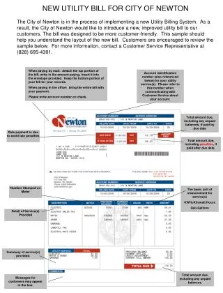
Development Of A Stormwater Utility For The City Of Brunswick, Ohio. John R. Woodard, MS GIS Specialist Chagrin Valley Engineering, Ltd. 2012 Ohio GIS Conference September 19 - 21, 2012 | Hyatt Regency Hotel | Columbus, Ohio. Why A Stormwater Utility?.

E N D
DevelopmentOf A StormwaterUtilityForTheCity Of Brunswick, Ohio John R. Woodard, MS GIS Specialist Chagrin Valley Engineering, Ltd. 2012 Ohio GIS Conference September 19 - 21, 2012 | Hyatt Regency Hotel | Columbus, Ohio
Why A Stormwater Utility? • Increased environmental mandates & aging stormwater infrastructure systems have placed significant financial burdens on local municipalities. • A stormwater utility provides a consistent stream of revenue that is dedicated to addressing stormwater systems regulatory compliance, maintenance and improvements.
GIS Tasks For The Stormwater Utility Implementation • Digitize and quantify impervious surface areas. • Determine an Equivalent Residential Unit (ERU) standard value. • Create a map showing the ERU values. • Create a customer list based on parcel database and ERU calculations. • Create a map viewer of the ERU map.
Impervious Surface Digitizing • Examples of Impervious Surfaces • Driveways & Parking Lots • Sidewalks • Buildings • As – Built plans were used for sites constructed after the date of aerial photo. • Digitized polygons were then used to calculate the square footage of impervious surface.
Digitizing: Use of As-Built Plans • Site plan showing impervious surfaces converted to jpeg. • Adobe Photoshop is used to crop desired area to parcel lines. • Jpeg imported into ArcGIS and then geo-referenced to the parcel lines in the Parcel feature dataset. • Impervious surfaces polygons are then digitized with the ArcGIS editing tools.
Digitizing Challenges 1. Accuracy of information 2. Multiple parcels with same owner. 3. Determining ownership of parcels. • Condominium Associations • Homeowner Associations • Cluster Home Associations
Accuracy • Aerial photographs • 2006 State of Ohio imagery program • Impervious surfaces were digitized at the ratio of 1:720 • When available, Impervious Surfaces where digitized directly from the As-Built plans. • A sampling of digitized areas were field measured to check GIS accuracy.
Multiple Parcels: Situation #1 A building or parking lot with common ownership spans one or more parcels.
Multiple Parcels: Situation #2 Original Lot Lines Creates Duplicates The map on the left shows the original lot line in red, cutting through several parcels. Below the attribute table reveals how this can create duplicate parcels.
Who Owns What?.... • Open Space Parcels • Not developed, odd shaped, easements, etc. • Not considered taxable by the county • Homeowner, Condominiums & Cluster Homes Associations • Responsible for public areas, streets, sidewalks • Open space parcels were combined into one polygon. • Combined polygons allowed a single ERU value to be calculated for all of an Association's open space.
Determination Of The Equivalent Residential Unit (ERU) • A sampling of residential parcels were digitized and the amount of impervious surfaces were averaged to create a Equivalent Residential Unit (ERU). • It was determined in the City of Brunswick that 1 ERU = 3,500 sq ft of impervious area.
The final product of the ERU determinations and digitizing efforts was a city wide map of ERU values.
A Customer List • Parcel ownership information from the Medina County Auditor was added to the ERU attribute table. • The combination of county data and ERU values enables the generation of a customer list. • This list was provided to city leaders for the purpose of establishing the billing process.
The Map Viewer • A map viewer was created for ArcReader with ArcPublisher. • This ArcReader viewer was distributed to city departments (Service, Building, and Finance). • City employees can quickly access the ERU map information to answer questions from the public.
Project Accomplishments • Determined that the City of Brunswick has a total of 19,382 ERUs. • Digitizing achieved an average accuracy level of +/- .4 to .09%. • A Map of ERU values was created. • A list of customers by ERU value was created and delivered to the city. • A map viewer was completed and distributed among city departments.
ARE THERE ANY QUESTIONS? THANK YOU FOR ATTENDING THIS PRESENTATION. John R. Woodard, MS GIS Specialist Chagrin Valley Engineering, Ltd. Phone: 440-399-0841 Email: woodard@cvelimited.com