Download
1 / 13
150 likes | 494 Views
The NASA/JPL Airborne Synthetic Aperture Radar System (AIRSAR). Yunling Lou Jet Propulsion Laboratory 4800 Oak Grove Drive Pasadena, CA 91109. AIRSAR System Characteristics. Simultaneous three-frequency and quad-polarization system P-band (0.68 m), L-band (0.25 m), and C-band (0.057 m)

E N D
The NASA/JPL Airborne Synthetic Aperture Radar System (AIRSAR) Yunling Lou Jet Propulsion Laboratory 4800 Oak Grove Drive Pasadena, CA 91109
AIRSAR System Characteristics • Simultaneous three-frequency and quad-polarization system • P-band (0.68 m), L-band (0.25 m), and C-band (0.057 m) • Along-track (ATI) and cross-track (XTI) interferometry capabilities in L & C-band • Bandwidth: 20 MHz, 40 MHz, or 80 MHz (L-band only) • Look angle: typically 25o ~ 62o • Range swath: ~ 10 km (40 MHz bandwidth) or 15 km (20 MHz bandwidth), 5 km (80 MHz bandwidth) • Noise equivalent sigma0: -45 dB (P/L-band), -30 dB (C-band) • Platform: DC-8 at 8 km altitude
CLPX Data Collection Plan The objectives of the AIRSAR data collection for CLPX were: • Obtain complete coverage of the three MSAs at Rabbit Ears, North Park, and Fraser in POLSAR mode to validate SWE algorithm • Generate DEM mosaics of the Rabbit Ears, North Park, and Fraser MSAs at 5 m posting • Collect AIRSAR data in different seasons in 2002 • Collect AIRSAR data in different snow conditions in March 2003
CLPX Data Collection Summary • AIRSAR collected data at all three CLPX sites in February, March, and September of 2002 and in March of 2003 • Total number of flight lines: 187 • Total raw data volume: about 1.8 TB (935 minutes) • Total processed data volume is estimated to be about 280 GB
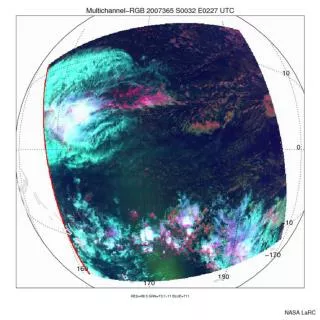
Example POLSAR Imagery over Fraser, Colorado P/L/C-band overlay of Fraser270-1, collected on 27 Feb, 2002
Example TOPSAR DEM over Rabbit Ears, Colorado C-band DEM of Rabbit Ears 270-1 collected on 13 Feb, 2002
CLPX Data Processing Status • We have processed about 40 flight lines’ of data to date • We are requesting additional processing funding to speed up the processor throughput • We are requesting additional funding to develop software to generate geo-referenced radar data products in a standard GIS format and to generate mosaics of all three MSA sites.
AIRSAR Data Access • Survey imagery of all the CLPX flight lines are available on AIRSAR’s website • JPEG files of all processed imagery are available on AIRSAR’s website • Request for duplicates of precision data products may be submitted to AIRSAR’s website after the one-year embargo period expires • AIRSAR’s website: http://airsar.jpl.nasa.gov/
Summary AIRSAR data can contribute to the cold land processes experiment in the following area: • Soil moisture measurement (POLSAR) • Surface roughness in sparsely vegetated area (POLSAR) • Biomass measurement of forested area (POLSAR) • Snow cover and snow wetness classification (frequency diversity and TOPSAR data) • Canopy (type and freezing) classification • Topography measurement (TOPSAR) • Canopy height measurement (TOPSAR) Note: TOPSAR data are used to remove terrain dependence in the POLSAR data
POLSAR Mode The characteristics of POLSAR mode are: • Simultaneous P, L, C-band quad-polarizations (HH, HV, VH, VV) • Selectable chirp bandwidth (range resolution): 20 MHz, 40 MHz, 80 MHz (L-band only) • Co-registered output imagery in slant range projection (typically 3.3 m x 4.5 m pixel spacing) • Output data in compressed Stokes matrix format (10 bytes/pixel) • Cross-polarization isolation: better than -20 dB • Noise-equivalent sigma0: < -45 dB in P & L-band, < -30 dB in C- band • Absolute calibration: 3 dB for P-band and 2 dB for L & C-band • Relative calibration: 0.5 dB between polarization channels and 1.5 dB between frequencies
POLSAR Mode (cont.) • “sigma0c” program to extract arbitrary polarization combination from compressed Stokes matrix file. • Commercial software available to read AIRSAR data format: ENVI. • Polarimetric data are used to estimate soil moisture, surface roughness, forest biomass, and land cover classification. • Radars at longer wavelengths (P-band and L-band) are able to penetrate forest canopy and wet snow.
TOPSAR Mode The characteristics of TOPSAR mode are: • Simultaneous C-band cross-track interferometry (V-pol), L-band cross-track interferometry or polarimetry, and P-band polarimetry • Selectable chirp bandwidth (range resolution): 20 MHz, 40 MHz • Co-registered output imagery in ground range projection • Output DEM file in 5 m posting (40 MHz bandwidth) or 10 m posting (20 MHz bandwidth) • RMS height error: 1 - 3 m for C-band and 5 - 10 m for L-band • C and L-band DEMs provide information on differential penetration into tree canopy
TOPSAR Mode (cont.) Standard output data products include: • DEM file in 5 m or 10 m posting • VV magnitude imagery (calibrated radar backscattering cross- section) • Local incidence angle map • Correlation map • L-band (if available) and P-band compressed Stokes matrix files • All output files are co-registered in ground range projection • DEM is used for terrain correction on POLSAR data