Download
1 / 41
420 likes | 555 Views
Update of the CERSER TeraScan Cataloguing System and the TeraScan Image Processing Scripts. Jefferson Ridgeway, Derek Morris Jr., Tori Wilbon 2014 Multimedia Team. Abstract.

E N D
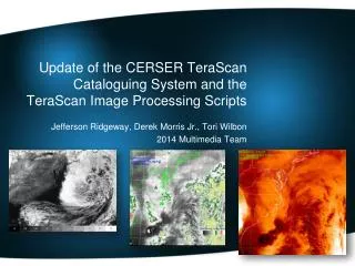
Update of the CERSER TeraScan Cataloguing System and the TeraScan Image Processing Scripts Jefferson Ridgeway, Derek Morris Jr., Tori Wilbon 2014 Multimedia Team
Abstract The Center of Excellence in Remote Sensing Education and Research (CERSER) on the campus of Elizabeth City State University is currently tasked with the responsibility of receiving remotely sensed data from orbiting National Oceanic and Atmospheric Administration (NOAA) Polar Operational Environmental Satellites (POES) and the Geostationary Operational Environmental Satellites (GOES). This data is collected by SeaSpace TeraScan systems installed in the CERSER labs in Dixon-Patterson Hall. In 2005, the processing system underwent a major update due to a migration to a new operating system. A minor update was needed at this time to deal with a second operating system migration and display of the processed images on the CERSER web site. Since then, a second transfer to a new server was made in 2013. The cataloguing system went down at this time and was not repaired due to technical issues with the TeraScan system. The 2014 team corrected issues within the current server directory system and updated the data script to process images from the GOES-13 satellite received by the TeraScan system. Software and languages utilized for this task included ImageMagick, PHP, HTML, Dreamweaver, phpMyAdmin, and MySQL. Along with this operating system update, a major script development was needed on the TeraScan processing equipment due to an upgrade in hardware. The ground station upgrades included a 3.7m X/L band, a 3.6m C band, and a 5.0m L band dishes, along with accompanying computing hardware. This new script processes both infrared and visible light images received from the GOES-13 satellite into the Tagged Image File (TIFF) Format.
Goals • CERSER Script Failures • Modify/Develop TeraScan Script • Rewrite CERSER Processing Script
What is TeraScan? • Purpose • Satellite Data Reception • Satellite Frequency • L-Band • Wavelength Range (1 -2 GHz)
TeraScan • 6 Different Channels/Bandwidths: • Channel 1 (visible) - Cloud cover and surface features during the day • Channel 2 (Infrared) - Low cloud/fog and fire detection • Channel 3 (Infrared) - Upper-level water Vapor • Channel 4 (Thermal Infrared) - Surface or cloud top temperature • Channel 5 (Thermal Infrared) - Surface or cloud top temperature and low-level water vapor • Channel 6 (Thermal Infrared) - Carbon dioxide band: Cloud detection
TeraScan • Software platform on TeraScan: RedHat Linux • Graphical User Interface (GUI’s) • TeraVision • TeraMaster
Data Processing in TeraScan • Configuration Directory • batch.ingest • gvarin • gvar.local • GOES VARiable Format (GVAR) data
Area Of Interest • Terminal • login to TeraScan Server • launchpad • TeraMaster • create an area of interest (AOI) or Master • save AOI
Modifying Configuration File • Script • configproc • function • parameters • TeraVision
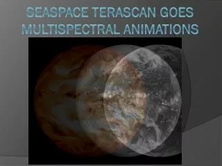
TeraVision Images Naked Channel 1 April 13 2014 18:15:49
TeraVision Images Channel 1 April 14 2014 18:15:49
CERSER Server Script Failures • Update of the database • GOES data • Directory Permissions • Picture Archives Directory
Server Side Script • Languages used: • PHP • MySQL • HTML • First used Active Server Page (ASP) • Was rewritten when switched from Windows to Macintosh
PHP • Introduction • Project Use
MySQL • Introduction • Project Use
HTML • Introduction • Project Use
Dreamweaver • Introduction • Project Use
phpMyAdmin • Introduction • Project Use
ImageMagick • Introduction • Project Use
ICal • Introduction • Project Use
Parse Title to Database • Title being used for database • 36 characters2014.0302.2001.goes-13.gvar_ch3.tiff • “substr” a PHP function
Parse Title to Database 2014.0305.1531.goes-13.gvar_ch1.tiff Characters Data 1-4 Year 6-7 Month 8-9 Day 11-14 Time(Z) 16-22 Satellite Name 24-31 Product (band) 32-36 File Extension (.tiff)
Checking for GOES Image ”IF” statement looks for “goes” starting at position 15. 2014.0305.1531.goes-13.gvar_ch1.tiff
Storing Satellite Name Parsing the satellite name 2014.0305.1531.goes-13.gvar_ch1.tiff
Storing Reformatted Date Parse and reformat the date into month/day/year 2014.0305.1531.goes-13.gvar_ch1.tiff
Storing Time Parsing the Greenwich Mean Time (GMT) 2014.0305.1531.goes-13.gvar_ch1.tiff
Storing the Product Parsing the product from the image title
Parse Product to Database Products Option Text String “1” Channel 1 Visible 0.52-0.72 m • “2” Channel 2 Infrared 3.78-4.03 m • “3” Channel 3 Vapor 6.47-7.02 m • “4” Channel 4 Upper Vapor 10.2-11.2 m • “5” Channel 5 Thermal IR 11.5-12.5 m • “6” Channel 6 Thermal IR 12.9-13.7 m “S” Sea Surface Temperature
Inserting Record into Database MySQL Query
Resize/Rename/Copy IMG • ImageMagick • Converted TIFF files to JPEG format • Resized images • Copy images into four directories: • Actual • Medium • Low • Thumbnail
Resize/Rename/Copy IMG • Renaming image: • $lastID as variable • “mysql_insert_id()” PHP function • Use $lastID to rename the new file
Results • Images are able to process • Permissions were changed: • Images can be modified for database • Parsing of title is successful • Resizing, Renaming, and Copying of images is still successful.
Conclusion • Able to use GUI’s to modify/develop script in TeraScan • Production of images, even though they are low in resolution • Daily Automated Process was not completed • To process and finalize images to send from TeraScan server to CERSER server • Images from TeraScan are reduced in size • PHP is still a functioning language to process TeraScan produced images.
Future Work • To accomplish a daily automated process of images from the TeraScan server to the CERSER server • To increase the image size of the pictures in the script and have a script that will connect from the TeraScan server to the CERSER server. • Add channels to TeraScan software • Rewrite script to add the NOAA satellite information. • When other channels are added to the GOES.
Acknowledgements • Dr. Linda Hayden • Andrew Brumfield • Seaspace
Demonstration http://cerser.ecsu.edu/