Download
1 / 19
190 likes | 271 Views
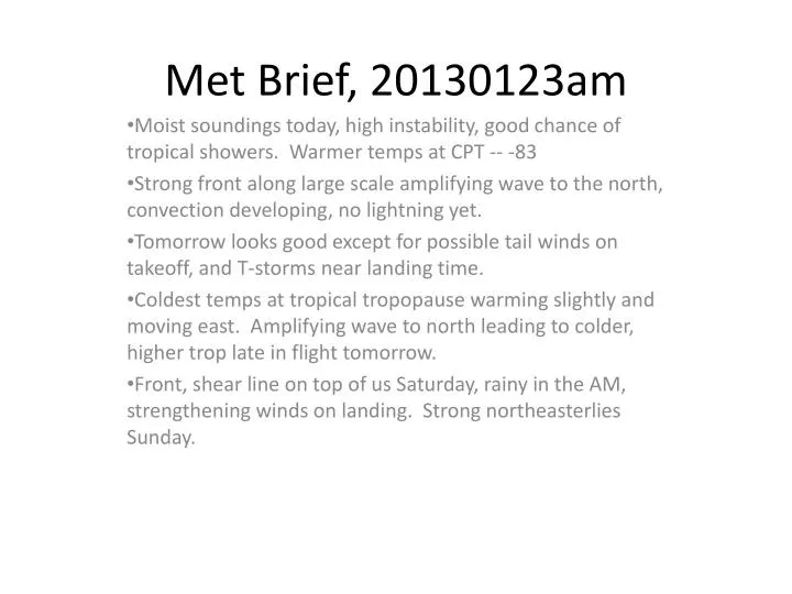
Met Brief, 20130123am. Moist soundings today, high instability, good chance of tropical showers. Warmer temps at CPT -- -83 Strong front along large scale amplifying wave to the north, convection developing, no lightning yet.

E N D
Met Brief, 20130123am Moist soundings today, high instability, good chance of tropical showers. Warmer temps at CPT -- -83 Strong front along large scale amplifying wave to the north, convection developing, no lightning yet. Tomorrow looks good except for possible tail winds on takeoff, and T-storms near landing time. Coldest temps at tropical tropopause warming slightly and moving east. Amplifying wave to north leading to colder, higher trop late in flight tomorrow. Front, shear line on top of us Saturday, rainy in the AM, strengthening winds on landing. Strong northeasterlies Sunday.
Moist sounding last night, more unstable than typical this time of year. Tropical showers today in unstable air. Minimum temperatures are -84 last night, significantly warmer than in past few days. This morning even more unstable, though not quite as moist at midlevels. CPT temperatures continue some warming.
Can see small showers to the SE moving north. Tropical system is now near 20N and interacting with developing wave and associated front to the northwest. Can see convection developing along front, but no lightning as yet.
Near TO. As front/shear line moves closer (and the low), winds shift to SW. Tail winds Near the 10 knot limit. Showers possible
Front advances, putting us closer to low center and reducing mean winds from the SW somewhat. NWS calling for slight chance of thunder. This needs to be watched, call GH back early maybe.
Both GFS and NCAR WRF show low developing west of Guam, and line of showers propagating eastward. If this develops, it will hold off on frontal movement, but give us a band of showers just to the west. Need to watch this.
Frontal passage Saturday, significant rain and gusty winds. We are at the edge of the strong northeasterlies at 4 PM on Saturday. Looks like rain on TO, and strong northeasterlies on landing.
Sunday may be another day of high winds from the northeast. Rain chances go down.
Coldest temperatures at 53kft have retreated to the SE, but developing trough is producing colder temperatures to the NW (below). This is a dynamic situation developing during the flight. Best viewed with Leslie’s animation.
Trajectory based cloud forecast. Not surprisingly, clouds forming in coldest temperatures
Input includes forecast and satellite/rain based convection coupled with forward trajectories. Expect to see convectively lofted air near tropopause that is fairly recent and has gone around the anticyclone.
Air we are sampling along northward trek is from convection near the equator. Air from yesterday’s system wil be over HI.
Note eastward propagtion of temperatures since Jan 20. At least at the equator, no warming seen, but warming at our longitudes is apparent.
Longer range convective forecast CPC MJO forecast – based on EOF analyses of 200mb zonal wind, 850mb zonal wind, and outgoing longwave radiation (satellite imagery). Inside circle indicates weak MJO pattern. Typical strong MJO is a large scale convective pattern propagating westward from the Indian Ocean into the Central Pacific at around 2-3 m/s. We have had a weak MJO most of the season. MJO is strengthening, but not propagating
Longer range convective forecast Curious behavior
Met Brief, 20130123am Moist soundings today, high instability, good chance of tropical showers. Warmer temps at CPT -- -83 Strong front along large scale amplifying wave to the north, convection developing, no lightning yet. CPT structure will be dynamic during the flight, with cold temps at 57kft developing at our location during the flight. Showers possible tomorrow, not as moist at upper levels, winds SW close to limits. Saturday front is on top of us, rain in the morning, possible strong Neasterlies by landing Sunday will have strong northeasterlies, but less rain Expect TTL clouds, most strongly in SE section of flight Expect recently lofted air (a few days) on northern trek. Warming at our longitudes at CPT expected in next few days. Convection in next few weeks expected to be anomalously strong in Western Pac/Maritime continent.