Download
1 / 15
150 likes | 236 Views
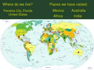
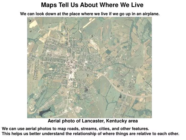
Maps Tell Us About Where We Live. We can look down at the place where we live if we go up in an airplane. Aerial photo of Lancaster, Kentucky area. We can use aerial photos to map roads, streams, cities, and other features.

E N D
Maps Tell Us About Where We Live We can look down at the place where we live if we go up in an airplane. Aerial photo of Lancaster, Kentucky area We can use aerial photos to map roads, streams, cities, and other features. This helps us better understand the relationship of where things are relative to each other.
Topographic Maps Aerial photos and ground surveys can be used to map the topography—the elevation of the land surface. Topographic maps illustrate the shape of the land. Contour lines on the map tell you the elevation of the land above sea level. Along a contour line the elevation remains the same. When contour lines are far apart, the land is relatively level. When contour lines are close together, the land is steeper. Topographic map of Lancaster, Kentucky area
20 foot contour lines in Mercer County In the picture above the land is relatively level on the hilltop where the roads are, but along the creek it is steep. Roads are often built along the ridgeline where the slopes are not steep. Find your home on your county map. What is the elevation near your home? Is the land steep or level?
Geology Maps Geologic map of the Lancaster, Kentucky area Geology maps show the different kind of rocks in an area. Geologists use topographic maps and field studies to map the rocks. Different colors are used to represent the different rocks. In Kentucky the rocks are called sedimentary rocks because they were formed from sediment eroded from the land and deposited in shallow seas. As the sediments were covered deeper and deeper, they became compressed into rock. The process of sedimentary rock formation took millions of years. Sedimentary rocks in Kentucky are limestone, dolomite, shale, siltstone, sandstone, conglomerate, and coal. Some are over 400 million years old. Geology maps also show geologic faults, mines, and mineral deposits. What kinds of rocks are in your county? There may be a photo on your map that shows what the rocks look like.
Direction and Scale Most maps have north at the top, indicated by a north arrow pointing straight up, west-left, east-right, and south-down. A map is a scaled-down representation of the real world. The scale above tells you that one inch on the map = 63,360 inches in the real world. Since 63,360 inches = 5,280 feet = 1 mile, then one inch on the map equals one mile in the real world. If the scale is 1:48,000, then 1 inch on the map = 48,000 inches in the real world = 4,000 feet = .76 miles, or about ¾ of a mile.
Map Features In addition to roads, streams, cities, and towns, there are many features on a map. The legend tells you what the map symbols mean. What features are on your map? Your map has many pictures that were taken in the county. If there is a number on the picture, you can look on the map for the number and see where the picture was taken.
Water Kentucky gets about 45 inches of rain every year. When there is a heavy rain and water flows along the ground, it erodes the soil and the rocks below. The creeks on the right have eroded channels down the side of the hill. The dashed blue line is the watershed divide along the ridge of the hill. Water on the left side of the hill flows north and west; water on the right side of the hill flows south and east. Rainfall percolating into the ground may emerge from a spring. Springs may feed small ponds like those seen above. The map symbol for a spring looks like a little fish. Look in the legend of your map and see if there is a symbol for springs. Can you find a spring on the map? Kentucky has more miles of streams, almost 90,000, than any other state but Alaska. The branches of a stream at the beginning are called first order streams. When two first order streams come together, they form a second order stream. When two second order streams come together, they form a third order stream, and so forth. Do you live near a stream? What is the order of the stream near your house? Flooding of streams can be a problem in Kentucky. On the map above, the slanted blue lines indicate the area where this stream may flood. Some of the smaller streams have no name. If you find an unnamed stream, you may be able to give it a name that will be on new maps. Contact the Kentucky Geological Survey to get help with this. Many people get water from underground wells. The blue circles on the map above represent water wells at a home. Are there any wells on your map? Monitoring wells are used to make sure that groundwater is not polluted.
Karst Karst areas are underlain by limestone containing sinkholes and caves. Water dissolves the limestone and flows underground so there are fewer streams on the surface. About half of Kentucky is karst. Do you live in a karst area?
More about Karst If you live in a karst area, your map will show sinkholes like those below. Karst in Warren County There are many sinkholes in Warren County, shown above. Do you see any streams? The water flows through the limestone beneath the ground.
Below the Ground in Karst Country In karst areas, water flows through the limestone beneath the ground.
Environmental Protection Someone has thrown trash in the sinkhole above. If you throw trash in a sinkhole it can pollute water in streams far away.
Finding a place to live If you build your house on the side of a hill, the rocks may not be strong enough to hold it, or there may be a landslide. You need to know what kind of rocks will be below your house. What kind of rock is beneath your house? What kind of rock is your school built on?
Geologic Faults Most geologic faults in Kentucky are inactive, but you need to know where the faults are when you build. The underlying rocks may change quickly on either side of a fault, as seen above in Scott County. Are there faults on your map?
Flooding If you build your house too close to a stream, it might get flooded. Alluvium—yellow on the map— lies along streams and indicates possible areas of flooding, like those shown below in Floyd County. Also, some of the flood zones have been mapped. Can you find any flood zones on your map? Parks and athletic fields are a good use for floodplains.
Sinkholes If you are on limestone in a karst area, you have to know where the sinkholes are before you build your house. Sinkholes and cave ceilings can also collapse suddenly. Like streams, sinkholes can flood after a heavy rain. Sinkhole flooding in Jessamine County Sinkhole collapse in Warren County There are many things to consider when you are looking for a place to live. Maps can help you decide. What is the biggest town or city in your county? Why do you think they built it where they did?