Download
1 / 3
30 likes | 148 Views
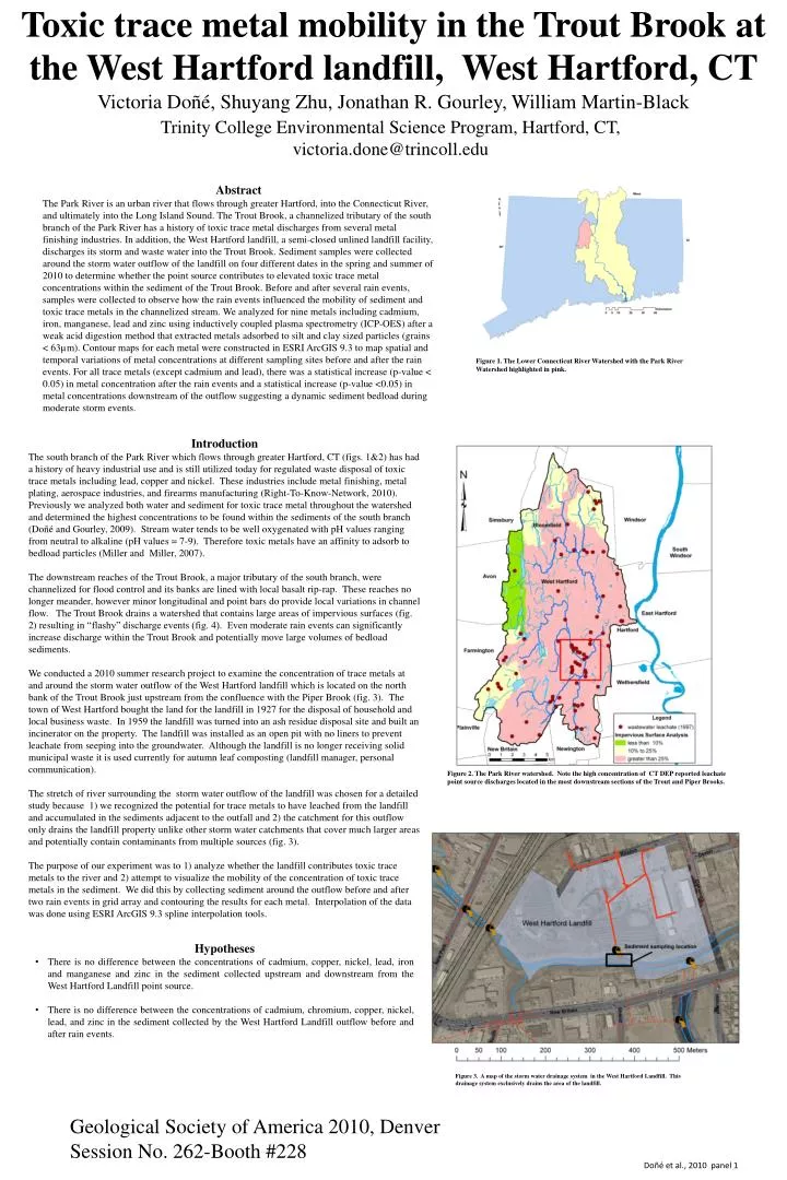
Toxic trace metal mobility in the Trout Brook at the West Hartford landfill, West Hartford, CT. Victoria Doñé , Shuyang Zhu, Jonathan R. Gourley , William Martin-Black. Trinity College Environmental Science Program, Hartford, CT, victoria.done@trincoll.edu. Abstract

E N D
Toxic trace metal mobility in the Trout Brook at the West Hartford landfill, West Hartford, CT Victoria Doñé, Shuyang Zhu, Jonathan R. Gourley, William Martin-Black Trinity College Environmental Science Program, Hartford, CT, victoria.done@trincoll.edu Abstract The Park River is an urban river that flows through greater Hartford, into the Connecticut River, and ultimately into the Long Island Sound. The Trout Brook, a channelized tributary of the south branch of the Park River has a history of toxic trace metal discharges from several metal finishing industries. In addition, the West Hartford landfill, a semi-closed unlined landfill facility, discharges its storm and waste water into the Trout Brook. Sediment samples were collected around the storm water outflow of the landfill on four different dates in the spring and summer of 2010 to determine whether the point source contributes to elevated toxic trace metal concentrations within the sediment of the Trout Brook. Before and after several rain events, samples were collected to observe how the rain events influenced the mobility of sediment and toxic trace metals in the channelized stream. We analyzed for nine metals including cadmium, iron, manganese, lead and zinc using inductively coupled plasma spectrometry (ICP-OES) after a weak acid digestion method that extracted metals adsorbed to silt and clay sized particles (grains < 63µm). Contour maps for each metal were constructed in ESRI ArcGIS 9.3 to map spatial and temporal variations of metal concentrations at different sampling sites before and after the rain events. For all trace metals (except cadmium and lead), there was a statistical increase (p-value < 0.05) in metal concentration after the rain events and a statistical increase (p-value <0.05) in metal concentrations downstream of the outflow suggesting a dynamic sediment bedloadduring moderate storm events. Introduction The south branch of the Park River which flows through greater Hartford, CT (figs. 1&2) has had a history of heavy industrial use and is still utilized today for regulated waste disposal of toxic trace metals including lead, copper and nickel. These industries include metal finishing, metal plating, aerospace industries, and firearms manufacturing (Right-To-Know-Network, 2010). Previously we analyzed both water and sediment for toxic trace metal throughout the watershed and determined the highest concentrations to be found within the sediments of the south branch (Doñé and Gourley, 2009). Stream water tends to be well oxygenated with pH values ranging from neutral to alkaline (pH values = 7-9). Therefore toxic metals have an affinity to adsorb to bedload particles (Miller and Miller, 2007). The downstream reaches of the Trout Brook, a major tributary of the south branch, were channelized for flood control and its banks are lined with local basalt rip-rap. These reaches no longer meander, however minor longitudinal and point bars do provide local variations in channel flow. The Trout Brook drains a watershed that contains large areas of impervious surfaces (fig. 2) resulting in “flashy” discharge events (fig. 4). Even moderate rain events can significantly increase discharge within the Trout Brook and potentially move large volumes of bedload sediments. We conducted a 2010 summer research project to examine the concentration of trace metals at and around the storm water outflow of the West Hartford landfill which is located on the north bank of the Trout Brook just upstream from the confluence with the Piper Brook (fig. 3). The town of West Hartford bought the land for the landfill in 1927 for the disposal of household and local business waste. In 1959 the landfill was turned into an ash residue disposal site and built an incinerator on the property. The landfill was installed as an open pit with no liners to prevent leachate from seeping into the groundwater. Although the landfill is no longer receiving solid municipal waste it is used currently for autumn leaf composting (landfill manager, personal communication). The stretch of river surrounding the storm water outflow of the landfill was chosen for a detailed study because 1) we recognized the potential for trace metals to have leached from the landfill and accumulated in the sediments adjacent to the outfall and 2) the catchment for this outflow only drains the landfill property unlike other storm water catchments that cover much larger areas and potentially contain contaminants from multiple sources (fig. 3). The purpose of our experiment was to 1) analyze whether the landfill contributes toxic trace metals to the river and 2) attempt to visualize the mobility of the concentration of toxic trace metals in the sediment. We did this by collecting sediment around the outflow before and after two rain events in grid array and contouring the results for each metal. Interpolation of the data was done using ESRI ArcGIS 9.3 spline interpolation tools. Figure 2. The Park River watershed. Note the high concentration of CT DEP reported leachate point source discharges located in the most downstream sections of the Trout and Piper Brooks. • Hypotheses • There is no difference between the concentrations of cadmium, copper, nickel, lead, iron and manganese and zinc in the sediment collected upstream and downstream from the West Hartford Landfill point source. • There is no difference between the concentrations of cadmium, chromium, copper, nickel, lead, and zinc in the sediment collected by the West Hartford Landfill outflow before and after rain events. Figure 3. A map of the storm water drainage system in the West Hartford Landfill. This drainage system exclusively drains the area of the landfill. Geological Society of America 2010, Denver Session No. 262-Booth #228 Doñé et al., 2010 panel 1 Figure 1.The Lower Connecticut River Watershed with the Park River Watershed highlighted in pink.
Methods Sample Collection: Using acid-washed plastic scoopers, sediment was collected at each site by wet-sieving through a 63 µm nylon filter into a #2 HDPE bottle rinsed with 5% hydrochloric acid. The samples were collected before and after two separate rain events: 1) between 5/18/10 – 5/20/10 and 2) between 6/15/10 – 6/25/10. The sampling that occurred before and after the May rain only included 12 sampling points. These locations (spaced at 5m intervals upstream to downstream; 2.5m intervals cross-stream) were all marked with small rock cairns in attempt to sample at the same locations before and after the rain events. For the June sampling period we increased our sampling area to include 42 more points (54 points total) so that we could observe how the metals concentrations might change throughout the entire stream channel. These points were also marked with small rock cairns. In all cases we collected sediment from the upstream side of the cairns. Sample Analysis: We followed a weak-acid digestion method presented in Giddings et al. (2000). The sediment was dried out in an oven at a constant temperature of 65ºC.Afterwards, the sediment was weighed into 0.5g aliquots and digested in 5% hydrochloric acid. An oscillator was then used to vibrate the samples for two hours. The sediment and acid mixture was then filtered ( 45µm) and the remaining liquid was analyzed using an Inductively Coupled Plasma – optical emission spectrometer (ICP-OES). May 18 – 20 event Figure5. Differences in lead concentration and plume size found by the landfill outflow before and after May rain event. Before the rain event, the highest concentrations of lead were found along the north bank, downstream of the outflow. After the rain event, levels of high concentration appeared to move further downstream from the outflow and spread further into the middle of the river. The second map shows the broadening lead plume as it moves downstream and spreads away from the bank after the rain event. Figure 6. Copper concentrations found both upstream and downstream of the landfill outflow. The highest concentrations of copper before the May rain event were found to be directly under the outflow and along the north bank. After the May rain event concentrations of copper well above the consensus based PEC were found directly downstream the outflow, along the north bank and exposed sandbar. This suggests that the outflow is a point source of copper and that the rain event is a factor in the movement of copper concentrations away from the point source. . Figure 7. Cadmium concentrations at the landfill outflow before and after the May rain event. The concentrations of cadmium moved from upstream to downstream. The north bank, on which the outflow is located, had relatively higher cadmium concentrations. Figure 8. Zinc concentrations in the sediment by the landfill outflow before and after the May rain event. Before the rain event the highest concentrations were found directly under the outflow opening. After the rain event, levels of high concentration move further downstream and collect along the northern bank and sandbar where concentrations rise well above the consensus based PEC. Sampling Locations June 15-25, 2010 Sampling Locations May 18-20, 2010 Figure 4. Hydrograph of the data derived from an Onset HOBO pressure data logger placed at the landfill outflow. The pink regions highlight the two rain events that occurred between 5/18/10 – 5/20/10 and 6/15/10 – 6/25/10. Pressure data was adjusted for atmospheric barometric changes. June 15 – 25 event Figure 10. High concentrations of lead throughout our sampling area are shown, before and after the rain events that occurred between 6/15/10 and 6/25/10. The highest concentrations of lead were found directly downstream from the West Hartford Landfill outflow on the north bank. Figure 11. Concentrations of copper found both upstream and downstream of the landfill outflow. The highest concentrations of copper before the June rain events were found to be directly downstream of the outflow, around the exposed sandbar. After the rain event, high concentrations of copper were found throughout the sample area downstream of the outflow, with the largest plume located directly downstream of the outflow along the north bank. Figure 12. Cadmium concentrations around the landfill outflow on 6/15/10 and 6/25/10. Several rain events took place between these two time periods. The highest concentrations of cadmium were not located near the landfill outflow, so that the outflow may not be the only point source that caused cadmium contamination in the sediment. Accumulation of cadmium may have been influence by the construction of our cairns. Figure 13. High concentrations of zinc directly downstream of the landfill outflow before and after the rain events that occurred between 6/15/10 and 6/25/10. On both sampling dates, the highest concentrations of zinc were found directly downstream of the landfill outflow along the north bank. Doñé et al., 2010 panel 2
Results The concentrations of toxic trace metals in the finest fraction of sediment (< 63 μm) were mapped using ESRI ArcGIS 9.3. Contours were derived using the spline interpolation tool. Each pair of figures presents a comparison before and after their corresponding rain event. The concentrations of metals from the May rain event are represented in Figs. 5-9 while Figs. 10-14 represent the June event. The different colors represent the different metals for easy comparison. The gradients of metal concentrations are presented in a color ramp with the darkest colors being the areas of the highest concentrations. Regions with metal concentrations that exceed consensus-based probable effect concentrations (PEC) are colored in red. These values represent the concentrations of metals that are potentially harmful to the biota (MacDonald et al. 2000). For the first hypothesis, the t-tests for cadmium and lead show that there was no significant difference (p>0.05) between the concentrations downstream and upstream from the outflow while for chromium, copper, iron, manganese, nickel, and zinc, there was a significant difference (p<0.05). For the second hypothesis, the t-test showed that there was no significant between the metal concentrations before and after the first rain event (p>0.05). However, every metal except for nickel and lead presented a significant difference between the metal concentrations before and after the second rain event (p<0.05). Note that iron, manganese and chromium are not shown. Table 1: The metal concentrations of the water coming out of the West Hartford Landfill storm water outflow in ppm. This data was collected in the summer of 2009. Discussion We can neither completely reject nor completely accept either of our two hypotheses. For the first hypothesis, most trace metals showed a statistically significant difference between downstream and upstream locations relative to the outflow suggesting it is possible that the landfill outflow may be contributing to trace metal contamination of the sediment. Another factor that may contribute to this contamination is the high rate of colloid formation at waste plume fronts (Wan et al., 2001). The water from the landfill may be contaminated with trace metals (table 1), so these metals, through the colloids, are readily adhering to the sediment grains. However, several maps show that there are “hotspots” of metals in certain places throughout the river channel. These are especially noticeable in the maps of the second sampling period, after the rain event. We interpret that these hotspots may be due to our construction of the small cairns (Photo 1). The cairns may have changed the hydrological conditions- creating low-velocity zones in the channel and effectively trapping trace metal laden bedload sediment from upstream sources. Another possible interpretation for the high concentration of trace metals below the outflow is the presence of a low profile sandbar a couple of meters downstream from the outflow. Table 1 shows that there are metals in the water coming out of the landfill but these concentrations are well below those found in the sediment. This suggests that metals precipitate rapidly when the outfall effluent mixes with river water and accumulates first within sediments of a small deep pool below the outfall and then can be flushed downstream to the sand bar. This is observed for metals during the May rain event. The sandbar also has the potential to accumulate metals from other upstream sources and thus may overestimate the contribution from the landfill. For the second hypothesis, the negligible difference between the metal concentrations before and after the May rain event may be due to the fact that the water level did not rise enough for there to be significant movement of the bedload particles. Comparably, most metals in the second rain event showed a significant difference because we had placed 54 cairns throughout the stream channel thus changing the hydrology of the channel. Maps of lead (Pb) from the June event show that the entire channel is contaminated with lead. All of this lead could not have been discharged from the outflow suggesting that this lead came from sources upstream and were trapped by the cairns. Thus the cairns, while they were useful in marking where we were collecting our samples from, may have compromised the experiment. However we were able to conclude that trace metal contaminants may also be flowing downstream from industries upstream from the outflow. • Conclusions • We interpret the high concentrations of copper and zinc in the sediments below the landfill outfall to be from the landfill storm water point source discharge. However the position of a low profile sand bar at this same location may also accumulate metals from other upstream sources. • Lead appears to be in high concentration throughout the river sediments and the landfill does not appear to be a significant source. • Minor hydrological changes in channel velocity can significantly affect the accumulation of metal laden sediment. Our construction of small rock cairns to mark sampling locations created local velocity decreases resulting in metal “hotspots” where trace metals accumulated. • References • Doñé, V., and Gourley J., 2009, Trace metal dispersal in the south branch of the Park River watershed and its possible impact on the Connecticut River sediments, Hartford, CT in: Geological Society of America Abstracts with Programs, vol. 41 no. 7 p. 330 • Giddings, M. I. (2001). Trace-Metal Concentrations in Sediment and Water • Hou, A., DeLaune, R. D., Tan, M., Reams, M., & Laws, E. (2009). Toxic Elements in Aquatic Sediments: Distinguishing Natural Variability from Anthropogenic Effects. Water, Air & Soil Pollution , 179-191. • Kauffman, G. J., & Belden, A. C. (2009). Water Quality Trends (1970 to 2005) Along Delaware Streams in the Delaware and Chesapeake Bay Watersheds, USA. Water, Air & Soil Pollution. • MacDonald, D. D., Ingersoll, C. G., & Berger, T. (2000). Development and Evaluation of Consensus-Based Sediment Quality Guidelines for Freshwater Systems. Environmental Contamination and Toxicology, 20-31. • Miller, J. R., & Miller, S. M. (2007). Contaminated Rivers. Dordrecht: Springer. • Right-to-Know Network. (2008, September 22). TRI Facilities for West Hartford, CT. Retrieved October 2, 2009, from Right-to-Know Network: http://www.rtknet.org/db/tri/tri.php?city=west+hartford&state=ct&dbtype=C&rsei=y&sortp=D&detail=-1&datype=T&reptype=f&reporting_year=&submit=G • Wan, J., Nokunaga, T. K., Saiz, E., Larsen, J. T., Zheng, Z., & Couture, R. A. (2004). Colloid Formation at Waste Plume Fronts. Environmental Science & Technology , 6066-6073. Photo 1: Cairns laid out in the stream channel. There were 54 cairns total that were arranged in 9 vertical transects with 6 cairns in each transect. Figure 14. Nickel concentrations in the sediment by the West Hartford Landfill before and after the June rain events. Before the rain events, the highest concentrations were found directly downstream of the outflow, after the rain events high levels of nickel moved further away from the outflow and accumulate near the middle of the channel where the concentrations rise well above the consensus based PEC. These “hotspots” are most likely due to the rock cairns placed in the river to mark locations. Figure 9. Concentrations of nickel found both upstream and downstream of the landfill outflow. The highest concentrations of nickel before the rain event on 5/18/10 were found to be directly under the outflow. After the rain event, high concentrations of nickel were found directly downstream of the outflow, along the north bank and exposed sandbar. This suggests that the outflow may be the source of nickel and that the rain event is a factor in the migration of the nickel concentrations away from the point source. Acknowledgments We would like to thank the Trinity Faculty Research Committee for the grants to facilitate our research. Doñé et al., 2010 panel 3