Download
1 / 37
400 likes | 574 Views
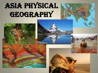
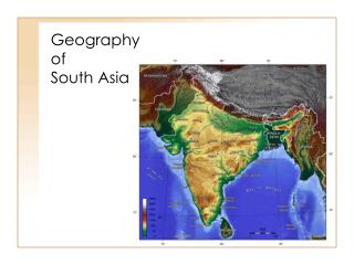
Geography of Asia. Essential Question. How does the geography impact the population distribution of Southern and Eastern Asia?. Standards. SS7G9 The student will locate selected features in Southern and Eastern Asia.

E N D
Essential Question • How does the geography impact the population distribution of Southern and Eastern Asia?
Standards SS7G9 The student will locate selected features in Southern and Eastern Asia. • a. Locate on a world and regional political-physical map: Ganges River, Huang He (Yellow River), Indus River, Mekong River, Yangtze (Chang Jiang) River, Bay of Bengal, Indian Ocean, Sea of Japan, South China Sea, Yellow Sea, Gobi Desert , Taklimakan Desert, Himalayan Mountains, and Korean Peninsula. • b. Locate on a world and regional political-physical map the countries of China, India, Indonesia, Japan, North Korea, South Korea, and Vietnam.
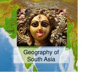
North Korea Japan South Korea China India Vietnam Indonesia
Geography of Southern &Eastern Asia • Mekong River is one of the longest rivers in Southern & Eastern Asia. • It stretches almost 2,700 miles long, runs through western China, Cambodia, Laos, Thailand and Vietnam, before emptying in the South China Sea.
Geography of Southern &Eastern Asia • Ganges River: Begins in the Himalayas, runs for 1560 miles. • Provides water to help support agriculture in this region. • Hindus sacred/ holy river.
Question #1 • The Mekong river delta is located in what country? A. VIETNAM
Geography of Southern &Eastern Asia • Indus River: longest river in Pakistan, is more than 1,900 miles long. • Empties into the Arabian Sea. Key water supply for Pakistan, making it the nation’s most important body of water.
Geography of Southern &Eastern Asia • Huang He: China’s second longest river, “Yellow River,” because of the color of the silt. • Causes deadly and destructive flooding, and is therefore referred to as “China’s Sorrow.”
Geography of Southern &Eastern Asia • Yangtze River: is China’s longest river, stretches almost 3,500 miles in length. Provides important resources to the country (i.e. oil, natural gas, copper, and iron ore).
Geography of Southern &Eastern Asia • Indian Ocean: • Makes up 1/5th of all ocean water in the world. • Stretches nearly 6,200 miles from the Southern tip of Africa to Australia. • Touches Iran, Pakistan, India and Bangladesh in the north. • Indonesia, and Australia to the east • Antarctica to the south • African and the Arabian peninsula to west • Indian Ocean CONNECTS Southern & East Asia to Europe and Africa
Question #2 • What is the longest river in Pakistan? A. Indus River
Geography of Southern &Eastern Asia • Bay of Bengal: lies to the northeast of the Indian Ocean. • Serves as a major fishery for the people in this region. • Also provides ports for shipping and has been an important body of water for international trade.
Geography of Southern &Eastern Asia • Yellow Sea: lies between China and Korean Peninsula. • Its name comes from the color of the silt-laden water that runs into it from some of the major rivers of China. • Serves as an important trade route and is home to important seaports.
Question #3 • Where would you find the bay of Bengal? A. Off the East coast of India
Geography of Southern &Eastern Asia • South China Sea: bordered by the Taiwan Strait, Taiwan, the Philippines, Borneo, the Gulf of Thailand, the Malay Peninsula, and the Asian mainland. • Provides seafood for many of the people of East Asia. • Monsoons blow across the sea , greatly affecting, life in this region. • Also plays a crucial role in travel and trade.
Geography of Southern &Eastern Asia • Sea of Japan: borders Japan, Russia and the Koreas.
Geography of Southern &Eastern Asia • Land and Land Masses: • Himalayan Mountains: • Located in Southern and Eastern Asia, they are the highest mountains in the world.
Geography of Southern &Eastern Asia • Land and Land Masses: • Home to Mount Everest • which is more than (29,035 feet) 5 miles high and is the tallest mountain on earth.
Geography of Southern &Eastern Asia • Land and Land Masses: Himalayas stretch approximately 1,550 miles across parts of Pakistan, India, Nepal, Bhutan, China, and Myanmar.
Geography of Southern &Eastern Asia • Land and Land Masses: • Pamir Mountains: Asian mountain range in which many other ranges branch out of, they are located where, Afghanistan, China, and Tajikistan meet. Pamir Mtns. are referred to as the “Roof Top of the World” because many of the peaks in this region reach almost four miles above sea level.
Geography of Southern &Eastern Asia • Deserts: • Taklimakan Desert: • The Taklimakan Desert in northwest China is a vast region of sand desert sitting in a depression between two high, rugged mountain ranges. • the Taklimakan's rolling sand dunes stretch out over about 125,000 square miles in the Xinjiang region of China. • The desert is hemmed in to the north by the snow-covered Tien Shan Mountain range and to the south by the rugged Kunlun Mountains. • Desertification and shifting sand dunes are a major concern for the farmers and grazers who live at the desert's edge.
Geography of Southern &Eastern Asia • Gobi Desert: • Is a vast stretch of land roughly 1,000 miles long between 300 to 600 miles wide. • The desert lies between the Altai and Hangayn mountains and stretches across parts of Mongolia and China. • Much of the desert is made up of bare rock, rather than sand. • Winters are harsh, January average low -40 degrees Fahrenheit & July average high 113 degrees Fahrenheit. • Severe dryness limits vegetation; few plants and shrubs that grow. • Few people live in the desert, those that do, tend to live as nomadic herders.
Geography of Southern &Eastern Asia • Korean Peninsula: bordering China. • A peninsula is a body of land surrounded on three sides by water. • The peninsula is home to the nation of Korea. 684 miles long. • For most of its history Korea was a nation united by language and culture. • WWII, Korea was divided into North and South Korea. • South Korea usually has a warm and wet climate. • North Korea tends to be colder and has less than half of the average rainfall in South Korea.
India— • India is a subcontinent- which is a large landmass that is smaller than a continent • India has a population of more than 1 billion people. • Most of the population is located in cities, where they live in shacks and struggle to make a living. Most of the major cities face overpopulation • The other parts of the population live in rural areas where they work as farmers and live with their extended family in simple houses
China- • The majority of the population in China lives on the eastern coast. • Most of the people live in small, rural villages and work as farmers. • China’s Urban, or city, population is also on the rise because of the growing number of industries and trading taking place. Most of these Urban cities are located along the coast or major rivers.
JAPAN- Has one of the world’s strongest fishing economies It is a densely populated country (smaller than California with almost four times the population) Most of these people live in crowded cities! For example: Space is so limited in Tokyo that they have started building underground. Others live in rural villages where they work on farms. Problem with this is that most of the land in Japan is not arable.– this is why the cities are so crowded!!!!! Most of Japan’s food is imported
Koreas- • North Korea has large deposits of coal, iron, and other minerals– making it very rich in resources • South Korea and Japan are not so lucky • Both Koreas use their land to generate electricity • Most of the people in South and North Korea tend to live in cities • South Korea most of those cities are located along the coast. Very few people live in the rugged interior. • Life for people in the cities of North Korea is very different from that of people in South Korea. (NK= No cars, no rights, electricity shortages)
Vietnam- • Vietnam occupies the eastern and southern part of the Indochinese peninsula in Southeast Asia, with the South China Sea along its entire coast. • Vietnam is about twice the size of Arizona. The Mekong River delta lies in the south. • Besides rice, key exports are coffee, tea, rubber, and fisheries products.